
Central Valley (California) facts for kids
Quick facts for kids Central Valley |
|
|---|---|
| Great Central Valley, Great Valley, Golden Empire | |

Typical flat farmland of the Central Valley as seen from the air
|
|

United States Geological Survey map of their defined four major regions of the Central Valley
|
|
| Length | 450 mi (720 km) |
| Width | 40 to 60 mi (64 to 97 km) |
| Area | 18,000 sq mi (47,000 km2) |
| Depth | 2,000 to 6,000 ft (610 to 1,830 m) |
| Geology | |
| Type | Alluvial |
| Age | 2–3 million years |
| Geography | |
| Location | California, United States |
| Population centers | Sacramento, Fresno, Bakersfield, Stockton and Modesto |
| Borders on | Sierra Nevada (east), Cascade Range, Klamath Mountains (north), Coast Range, San Francisco Bay (west) and Tehachapi Mountains (south) |
| Traversed by | Interstate 5, Interstate 80 and State Route 99 |
| Rivers | Sacramento River, San Joaquin River and Kings River |
The Central Valley is a huge, flat valley in the middle of California, United States. It's about 40 to 60 miles (64 to 97 km) wide and stretches for about 450 miles (720 km) from north to south. This valley runs parallel to the Pacific coast. It covers about 18,000 square miles (47,000 km2), which is about 11% of California's total land. The Coast Ranges are to its west, and the Sierra Nevada mountains are to its east.
The Central Valley is famous for its farming. It grows a huge amount of the food produced in California. California itself provides more than half of the fruits, vegetables, and nuts grown in the United States! Over 7 million acres (28,000 km2) of the valley's land are watered using reservoirs and canals. Many cities are located here, including the state capital, Sacramento, along with Redding, Chico, Stockton, Modesto, Merced, Fresno, Visalia, Porterville, and Bakersfield.
The Central Valley's watershed (the area where all the water drains) is huge, covering over a third of California. It has three main water systems: the Sacramento Valley in the north, which gets a lot of rain; the drier San Joaquin Valley in the south; and the Tulare Basin at the very southern end, which has a dry, desert-like climate. The Sacramento and San Joaquin rivers drain their areas and meet to form the Sacramento–San Joaquin River Delta. This delta is a large area of connected canals, streams, marshes, and islands. The delta's water flows into the San Francisco Bay and then out to the Pacific Ocean. The water in the Tulare Basin usually doesn't reach the ocean, except for some Kings River water that is moved north for farming.
The valley includes all or parts of 18 California counties. Because it's far from most big commercial markets and faces some challenges, the valley has mostly focused on its role as a major farming area.
What's in a Name?
The Central Valley has been called other names, like "the Great Valley," which you might still see in science books. Another old name is "Golden Empire."
Some people living in the Central Valley think it only includes the San Joaquin Valley. This is because the northern Sacramento Valley and the San Joaquin Valley are quite different. The San Joaquin Valley is often drier and has more fertile soil, while the Sacramento Valley is wetter and has different soil. The large Sacramento River and its many branches in the north also make the two areas feel distinct.
People of the Central Valley

The Central Valley is home to many people. The main population centers, from south to north, are Bakersfield, Fresno, Sacramento, and Redding. These cities are important centers for business and transportation in their areas.
As of 2020, about 7.2 million people lived in the Central Valley, making it the fastest-growing region in California. The largest city is Fresno, followed by the state capital, Sacramento.
Languages and Cultures
After English and Spanish, Punjabi is the third most common language spoken in the Central Valley. The valley has the largest Sikh population in the United States.
How the Valley Was Formed (Geology)

The valley floor is very flat, which is different from most of California's rugged hills and mountains. Scientists believe the valley started as an area below sea level, pushed down by the movement of Earth's plates. The valley itself doesn't have many earthquake faults, but it's surrounded by them.

Over millions of years, the Coast Ranges rose up, enclosing the valley. The valley then filled with mud and sand from these mountains and the rising Sierra Nevada to the east. This filling made the valley incredibly flat and just barely above sea level. Before dams and canals were built, melting snow each year would turn much of the valley into a huge inland sea.
One unique feature in the flat valley is Sutter Buttes. These are the remains of an old volcano located northwest of Yuba City.
Sometimes, too much water is pumped from underground in the Central Valley. This can cause the land to slowly sink, a process called land subsidence.
Nature and Environment

Plants (Flora)
The Central Valley used to be a diverse area of grasslands, with different types of prairies, oak forests, and large lakes like the now-dry Tulare Lake. However, much of this natural environment has been changed by human activities, especially farming.
The main grass in the valley used to be Nassella pulchra, but today, only a small part of the original grasslands remains. You can still see beautiful flowers like the California poppy (Eschscholzia californica) and lupins, especially in Antelope Valley. Along the rivers, you'll find trees like willows, sycamores, and the special valley oak (Quercus lobata).
Animals (Fauna)

The Central Valley was once home to many animals, including pronghorn antelope, elk (like the unique tule elk), and mule deer. Smaller animals like squirrels, gophers, mice, and rabbits also lived here, along with predators like the San Joaquin kit fox. The valley's wetlands were very important for waterbirds and migrating birds. The Central Valley also has special fish species that live only there, such as the Sacramento pikeminnow.
Protected Areas
Some areas are protected to save parts of the valley's natural habitat. For example, the Great Valley Grasslands State Park protects native grasses. Other areas protect wetlands and riverside forests, like the Nature Conservancy's Cosumnes River Preserve. These protected areas are important because farming and development have changed most of the valley's original habitats.
Health and Air Quality
The Central Valley is known for a lung illness called Valley fever. It's caused by a fungus that lives in the soil. When the soil is disturbed by wind, construction, or farming, the tiny fungal spores can get into the air and be breathed in.
Air pollution is also a concern in the Central Valley. Farming activities release gases into the air, and the mountains surrounding the valley can trap this pollution. This means the air can sometimes be unhealthy for people living there.
Climate

The northern Central Valley has a hot Mediterranean climate, meaning it has hot, dry summers and cool, wet winters. The southern parts are even drier, almost like a desert. Summer days are often over 100°F (38°C), and sometimes even hotter, above 115°F (46°C). The rainy season is from mid-autumn to mid-spring. Snow is very rare.
Tule Fog

Tule fog is a very thick ground fog that forms in the valley during late fall and winter. It's named after the tule grass wetlands in the valley. This fog can make it very hard to see, and it's a leading cause of car accidents in California during the winter months.
Rivers and Water (Hydrography)


Two main river systems drain the Central Valley. The Sacramento River flows south through the Sacramento Valley, joined by rivers like the Feather River and American River. In the San Joaquin Valley, the San Joaquin River flows northwest, picking up water from rivers like the Merced River and Tuolumne River. These rivers eventually meet in the Sacramento-San Joaquin Delta.
In the southern San Joaquin Valley, rivers like the Kings, Kaweah, Tule, and Kern used to flow into a large seasonal lake called Tulare Lake. This lake would fill up with snowmelt each spring. Today, the lake is usually dry because its water is used for farming.
The Sacramento and San Joaquin rivers meet in the delta, a maze of channels and marshes. From there, the water flows through San Francisco Bay and out to the Pacific Ocean. Many delta islands are below sea level because of farming, which means they could flood if not protected.
The Sacramento River carries much more water than the San Joaquin River. Over 25 million people in California rely on the water from these rivers for their homes and farms.
Managing the Rivers
The Sierra Nevada mountains provide a huge amount of water for California. This water, combined with the fertile land of the Central Valley, makes it perfect for farming. To manage this water, many dams have been built on the rivers, like Shasta Dam and Oroville Dam. These dams help prevent floods and store water for dry seasons. However, they also changed the natural flow of rivers, which affected fish like the Chinook salmon.
Because cities like San Francisco Bay Area and Los Angeles need a lot of water, large projects like the California State Water Project were built. These projects move water from the northern Central Valley to the drier southern parts and to cities further south.
Flooding and Landslides
Many low-lying areas in the valley can flood, especially where old lakes like Tulare Lake used to be. Farmers and towns in these areas are protected by levees (walls built to hold back water). The Great Flood of 1862 was the worst flood in the valley's recorded history, covering most of it with water.
Heavy rainfall can also cause landslides in Northern California, including the Central Valley. When there's a lot of rain, the ground gets very wet, which can make the land slide. These landslides can cause damage to land and buildings.
Droughts
California often experiences droughts, which are long periods of very little rainfall. Droughts can harm forests and lead to wildfires because trees become very dry. Droughts also affect farming, causing losses for farmers and sometimes leading to job losses.
Economy of the Central Valley
Farming is the main industry in most of the Central Valley. However, the Sacramento area also has many government jobs. Sacramento's economy has grown and become more diverse, similar to the San Francisco Bay Area. Many people move to the Central Valley from the Bay Area looking for more affordable homes.
Farming (Agriculture)
The Central Valley is one of the most productive farming regions in the world. More than 230 different crops are grown here! Even though it's less than 1% of the total farmland in the United States, the Central Valley produces 8% of the nation's farm products by value. In 2013, this was worth $43.5 billion.
Almost all non-tropical crops grow well in the Central Valley. It's the main source for many foods across the United States, including tomatoes, grapes, cotton, apricots, and asparagus. For example, in 2000, almond growers produced over 600 million pounds (270 million kg) of almonds, which was about 70% of the world's supply!
The top four counties in the U.S. for agricultural sales are all in the Central Valley.
| County | Sales (2007) |
|---|---|
| Fresno County | $3.731 Billion |
| Tulare County | $3.335 Billion |
| Kern County | $3.204 Billion |
| Merced County | $2.330 Billion |
Early farming in the valley was near the Sacramento-San Joaquin Delta because water was easy to get there. Later, big irrigation projects helped bring water to many more parts of the valley, making them productive for farming.
Farmworkers' Rights
In the 1960s, leaders like Cesar Chavez and Dolores Huerta helped Mexican American grape pickers form a union called the National Farmworkers Association (NFWA). They worked to improve the difficult working conditions for farmworkers, especially in the Central Valley around Delano.
Utilities
The Oroville Dam in the Sacramento Valley provides water and power for the California Aqueduct in the San Joaquin Valley. The Central Valley Project also includes many facilities from north to south. Companies like Pacific Gas and Electric connect the northern and southern parts of the Central Valley with an electric grid to provide power.
Images for kids
-
United States Geological Survey map of their defined four major regions of the Central Valley
-
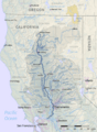
Sacramento River watershed
-
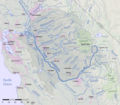
San Joaquin River watershed
-
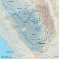
Tulare Basin watershed
See also
- List of regions of California
- Central Valley groundwater pollution
- Lake Corcoran
- Orland Buttes
- In Spanish: Valle Central de California para niños
