Tule River facts for kids
Quick facts for kids Tule River |
|
|---|---|

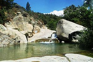
Waterfall on the Tule River
|
|

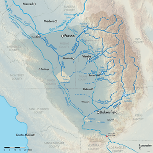
Map of streams and rivers in the Tulare Lake basin including the Tule River
|
|
| Other name(s) | Rio San Pedro |
| Country | United States |
| State | California |
| Cities | Springville, Porterville, Tipton, Corcoran |
| Physical characteristics | |
| Main source | Confluence of North and Middle Forks Springville, Tulare County 1,037 ft (316 m) 36°08′17″N 118°48′23″W / 36.13806°N 118.80639°W |
| River mouth | Tulare Lakebed Kings County 184 ft (56 m) 36°02′59″N 119°49′27″W / 36.04972°N 119.82417°W |
| Length | 71.4 mi (114.9 km) |
| Basin features | |
| River system | Tulare Lake basin |
| Basin size | 400 sq mi (1,000 km2) |
| Tributaries |
|
The Tule River is a river in Tulare County, California. It is about 71.4-mile (114.9 km) long. Sometimes, it is also called Rio de San Pedro or Rio San Pedro.
The river starts in the Sierra Nevada mountains, east of Porterville. It is made up of three main parts: the North, Middle, and South Forks. The North Fork and Middle Fork join together near Springville. The South Fork then meets them at Lake Success.
After flowing out of Success Dam, the river goes west through Porterville. In the past, the Tule River flowed into Tulare Lake. However, much of its water is now used for irrigation, which means watering crops. Even so, the river can still reach Tulare Lake when there are big floods. Tulare Lake is a "terminal sink," meaning water flows into it but does not flow out to the ocean.
Contents
History of the Tule River
Long ago, the Yaudanchi people lived along the Tule River. They were part of the larger Yokuts group. They lived in the foothills, especially near the North and Middle Forks of the river.
The name "Tule River" comes from a plant called "tule." These are tall, grass-like plants that grow in wet areas, similar to cattails. In 1806, an expedition led by Moraga named the river "Rio de San Pedro." Later, on a map from 1850, it was shown as both Tule River and Rio San Pedro.
The River's Journey
The Tule River is formed by several smaller streams, called forks. Each fork has its own path before joining the main river.
North Fork Tule River
The North Fork is about 18.9 miles (30.4 km) long. It starts high on a ridge and flows southwest through a canyon. This area is part of the Giant Sequoia National Monument.
As it flows, it is joined by Kramer Creek and Backbone Creek. Near Milo, the river turns southeast. Sycamore Creek and Whitney Creek also add their waters. Finally, the North Fork meets the Middle Fork at Springville.
Middle Fork Tule River
The Middle Fork is about 6.9-mile-long (11.1 km). It begins where two smaller streams meet: the South Fork Middle Fork Tule River and the North Fork Middle Fork Tule River.
The South Fork flows northwest from near Camp Nelson. The larger North Fork comes from inside Sequoia National Park. It flows over a waterfall before joining the South Fork. After they meet, the Middle Fork flows south and southwest. It then joins the North Fork to form the main Tule River.
South Fork Tule River
The South Fork Tule River is about 27.8-mile-long (44.7 km). It joins the main Tule River at Lake Success. This fork is formed by Blue Creek, Rocky Creek, Pigeon Creek, and Bond Creek near Soda Springs.
It flows west-southwest through a narrow canyon. Then, it turns northwest and receives water from Long Branch Creek and Crew Creek. The South Fork then forms an arm of Lake Success. There's a special place called "Painted Rock" along this fork. It's a cavern with ancient drawings, located on the Tule Indian Reservation.
Mainstem of the Tule River
From where the North and Middle Forks join, the Tule River flows about 10 miles (16 km) south and west. It continues towards Lake Success. Before reaching the lake, Campbell Creek and Graham Creek join it. The South Fork of the Tule River also flows into Lake Success.
After leaving Success Dam, the river flows west into Porterville. It then winds west towards where Tulare Lake used to be. It passes through cities like Tipton and Corcoran. The river then splits into many smaller channels. These channels are mostly used for watering farms. The river ends about 9 miles (14 km) east-northeast of Kettleman City in Kings County. Here, it connects with a canal that carries water from the Kings River.
 | James Van Der Zee |
 | Alma Thomas |
 | Ellis Wilson |
 | Margaret Taylor-Burroughs |

