
Kings River (California) facts for kids
Quick facts for kids Kings River |
|
|---|---|

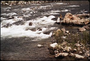
The Kings River in the San Joaquin Valley about 10 miles (16 km) below Pine Flat Dam
|
|

Map showing the Kings River and its tributaries. The canal system fed by Kings River is shown in light blue.
|
|
| Native name | Wimmelche |
| Country | United States |
| State | California |
| Region | Kings Canyon National Park, Fresno County, California, Kings County, California |
| Physical characteristics | |
| Main source | Confluence of Middle and South Forks Sierra Nevada 2,257 ft (688 m) 36°50′17″N 118°52′29″W / 36.83806°N 118.87472°W |
| River mouth | Tulare Lakebed San Joaquin Valley 184 ft (56 m) 36°03′00″N 119°49′28″W / 36.05000°N 119.82444°W |
| Length | 132.9 mi (213.9 km) |
| Basin features | |
| Basin size | 1,544 sq mi (4,000 km2) |
| Tributaries |
|
| Type: | Wild |
| Designated: | November 3, 1987 |
The Kings River is a 132.9-mile (213.9 km) long river in central California, United States. It starts high in the Sierra Nevada mountains. Its source is in Kings Canyon National Park, where it carves out Kings Canyon. This is one of the deepest river gorges in North America.
The river flows into Pine Flat Lake, a large reservoir. Then, it goes into the San Joaquin Valley near Fresno. In Kings County, the Kings River splits into many smaller streams. Some water flows south to the old Tulare Lake area. Other parts flow north towards the San Joaquin River. Most of the river's water is used for irrigation (watering crops) before it reaches these points.
For thousands of years, the Yokuts people and other native groups lived here. The Kings River basin once fed a huge system of wetlands around Tulare Lake. These wetlands supported millions of waterfowl, fish, and game animals. This provided food for the native people. Tulare Lake used to be the largest freshwater lake in the western U.S.
In 1806, a Spanish explorer named Gabriel Moraga named the river. By 1850, many Europeans settled along the Kings River. This changed the way of life for the native people. Logging and livestock grazing caused damage to the river system. Later, the government created national parks to protect these areas.
The Kings River has a long history of water use. Farmers began using its water for irrigation in the mid-1800s. In the early 1900s, Tulare Lake was drained for farming. The Pine Flat Dam, built in the 1950s, helped control the river's floods. Today, the river waters about 1.1 million acres (4,500 km2) of farmland. This land is some of the most productive in the country. The river is also used to create electricity and for fun outdoor activities.
Contents
Where the Kings River Flows
All three main branches of the Kings River start from melting snow in the high Sierra Nevada mountains. The Middle and South Forks begin in Kings Canyon National Park. They join together in the Monarch Wilderness to form the main Kings River. The North Fork joins the Kings River further downstream near Pine Flat Lake. Pine Flat Lake is the only large reservoir on the river.
Much of the upper Kings River is remote wilderness. You can only reach it by hiking or horseback. The upper part of the river is in Fresno County. In the Central Valley, the Kings River also flows through parts of Tulare County and Kings County.
River's Beginning: Headwaters
The South Fork is the longest branch, about 44-mile (71 km) long. It starts high on the Sierra Crest in Kings Canyon National Park. It flows through the Cedar Grove part of Kings Canyon. This is a valley with tall granite cliffs and green meadows.
The Middle Fork flows for 37 miles (60 km) through hard-to-reach areas of the park. The South and Middle Forks meet at 2,257 feet (688 m) elevation. This is just outside the national park, forming the main Kings River. Kings Canyon is very deep and narrow, even deeper than the Grand Canyon.

After the forks meet, the Kings River flows west for about 30 miles (48 km). It carves a canyon that is over 5,000 feet (1,500 m) deep in some spots. Hume Lake is formed by a dam on Tenmile Creek, a tributary here. Another cool spot is Garlic Falls, a waterfall over 800 feet (240 m) high.
The Kings River then passes Rodgers Crossing. It receives the North Fork from the right side near Balch Camp. The North Fork is about 40 miles (64 km) long. It flows mostly through the Sierra National Forest. It is dammed at Wishon Reservoir. This reservoir is part of the Helms Pumped Storage Plant, a big power plant.
The main Kings River then flows into Pine Flat Lake. This large reservoir was created by Pine Flat Dam. It can hold up to 1,000,000 acre-feet (1.2 km3) of water. Pine Flat Dam was built in 1954. It helps control floods, provides water for irrigation, and generates electricity.
The Lower River's Journey
The Kings River leaves the mountains near Piedra. This is about 10 miles (16 km) downstream from Pine Flat Dam. From there, it flows across the flat San Joaquin Valley. This valley is now one of the best farming areas in the U.S.
Here, the Kings River has many diversions. These are structures that send water to farms or help control floods. The Fresno Weir and People's Weir are two important ones. They send a lot of the river's water into canals. The Kings River flows past Sanger and Reedley. It then enters Kings County.
Near Kingsburg, a branch called Cole Slough splits off. It rejoins the main river about 10 miles (16 km) downstream. About 6 miles (9.7 km) north of Lemoore, the Kings River splits again. It forms the North Fork and South Fork (these are different from the forks in the mountains).
Fresno Slough branches off the North Fork. It flows northwest and carries floodwaters to the San Joaquin River. This is the only part of the Kings River that reaches the San Joaquin River and then the Pacific Ocean. The rest of the North Fork turns south and rejoins the South Fork.
From there, the Kings River flows south through Kings County. It passes Stratford and gets close to the old Tulare Lake bed. The river ends about 10 miles (16 km) northeast of Kettleman City. Today, the 44,000-acre (18,000 ha) old lake bed is used for farming. Dams and canals usually prevent flooding. But in very wet years, the lake can still reform.
River's Environment and Features

The Kings River is the largest river in the southern Sierra Nevada. It carries more water than the Kern, Kaweah, and Tule Rivers combined. Before Pine Flat Dam was built in 1954, the river's flow changed a lot. It was very high in May and June from melting snow. It was very low in September and October. After the dam, flows are more controlled.
In winter, rainstorms at lower elevations can cause floods. But these are smaller than the summer snowmelt floods. The Sierra mountains get a lot of rain and snow, up to 20 to 50 inches (510 to 1,270 mm) per year. But the San Joaquin Valley is dry, getting only 5 to 12 inches (130 to 300 mm) of rain.
Most of the river's water, about 71 percent, comes from snowmelt. This happens between April and July in the 1,544-square-mile (4,000 km2) area above Pine Flat Dam. Three-quarters of this rugged area is over a mile (1,600 m) high. The highest point is North Palisade, at 14,248-foot (4,343 m).
The Kings River canyons are geologically young. They were mostly carved out during the Pliocene and Pleistocene periods (5 million–12,000 years ago). This happened when the Sierra Nevada mountains rose quickly. During the ice ages, huge valley glaciers flowed down the river's forks. They changed the "V"-shaped river canyons into "U"-shaped gorges.
The lower Kings River forms a large, gently sloping alluvial fan. This is made of millions of years of eroded material from Kings Canyon. This fan raised the valley floor. It blocked water flowing north, creating a large bowl in the southern valley. This bowl formed the Tulare Lake basin. The soils here are good for farming.
Before people built levees and dikes, the Kings River often changed its path during floods. It sometimes flowed north to the San Joaquin River. Other times, it flowed south into Tulare Lake. It often did both. The river had a wide floodplain with many seasonal channels and marshes. These supported a rich riparian zone (riverbank habitat).
This flooding over thousands of years built up huge groundwater reserves. Today, these are a vital water source for farming. However, the groundwater levels have been dropping. This is due to a lot of pumping for irrigation.
Since 2000, the Kings River basin has had more dry years. Temperatures in Kings Canyon National Park have also been higher. Climate change is expected to greatly reduce the river's flow by 2100. A 2014 study found that the average river flow could drop by 26 percent. This is because warmer temperatures cause more plant growth. This means plants use more water. Also, more winter rain instead of snow means less water stored in snowpack for summer.
Animals and Plants of the Kings River

Most of the original wetlands and riparian zones in the valley are gone due to development. But narrow riparian corridors still exist along 40 miles (64 km) of the Kings River. These are found between Pine Flat Dam and People's Weir. The largest ones are in the Centerville Bottoms, east of Sanger. Here, the river splits into many channels.
Below Highway 99, most river channels have been changed by people. A minimum flow of 100 cubic feet per second (2.8 m3/s) is always released from Pine Flat Dam. This helps support fish and riverbank habitats.
In the foothills, California oak woodlands grow along the Kings River. These have blue and black oak trees. Other foothill areas have thick chaparral (dense shrubs). Higher up in the Sierra Nevada, mixed conifer forests are common. These have ponderosa pine and yellow pine.
Giant sequoias are found in this area. The General Grant Grove is about 10 miles (16 km) southwest of where the Middle and South Forks meet. The Kings River groves are smaller and closer to the South Fork.
Even higher in the Sierra, above 10,000 feet (3,000 m), you find subalpine forests. These have red fir, lodgepole pine, and mountain hemlock. Above this, the landscape is rocky with cirques (bowl-shaped valleys) and tarns (mountain lakes). Many wildflower and shrub species grow here.
The United States Forest Service manages parts of the Kings basin. They thin out plants and do prescribed burns. This helps reduce wildfire risk and improve water quality.
The Kings River above Pine Flat Dam has native rainbow trout. It also has introduced brown trout and smallmouth bass. The Upper Kings is a "Wild Trout Water." Rainbow trout are also below the dam. Other fish in the lower Kings include native Sacramento pikeminnow and Sacramento sucker. Introduced species like common carp and channel catfish are also found.
Early History of the Kings River

When Europeans first arrived, between 5,000 and 20,000 Native Americans lived along the lower Kings River. The Kings River area is the traditional land of the Yokuts people. Different Yokuts groups lived along different parts of the river.
The Yokuts mainly lived along the Kings River below the foothills. They also lived along the marshy edges of Tulare Lake. The many oak forests provided acorns, their main food. The wetlands gave them fish, waterfowl, and animals like beaver. Tule rushes were used to build homes and rafts. The Yokuts traded with the Mono people to the east.
The first Spanish explorers saw the Kings River on January 6, 1806. This was the day of the Epiphany, a Christian holiday. So, they named the river El Rio de los Santos Reyes ("River of the Holy Kings"). This name was later shortened.
Jedediah Smith was the first American explorer to see the Kings River in 1827. John C. Frémont tried to find a route over the Sierra Nevada via the Kings River in 1844. But he had to turn back due to deep snow. By 1852, the name Kings River was commonly used.

After California became a U.S. state in 1850, people started using the upper Kings River for logging and prospecting. The lower part was used for cattle and sheep ranching. Scottsburg, an early American town, was founded in 1854. It was later rebuilt as Centerville.
After the Kern River gold rush in 1853, many settlers came to Tulare County. Conflicts arose with Native Americans. Most native people who survived were forced to move from their lands along the Kings River. They were relocated to the Tule River Indian Reservation. Their descendants live there today.
From the 1860s to the early 1900s, logging was a huge industry. In 1890, the Kings River Lumber Company was started. They wanted to log the giant sequoias. A dam was built to form Hume Lake. A flume (a channel for water) carried logs 40-mile (64 km) down Kings Canyon to a mill. But logging sequoias was not very profitable. The wood was soft, and the tall trees often broke when they fell.
When John Muir visited Kings Canyon, he wrote about its beauty. He helped bring attention to the area. Muir pushed for the protection of the sequoia groves. These include General Grant Grove, home to the world's second-largest tree. In 1890, General Grant National Park was created. In 1940, the park was expanded to include the middle and south forks of the Kings River. It was then renamed Kings Canyon National Park.
Farming in the Kings Delta

The Kings River area was not easy for early settlers to farm. The river flowed in a deep channel, leaving the surrounding plains dry. Further downstream, near Tulare Lake, the land was too swampy. Farmers first preferred the Kaweah Delta to the south.
Farming along the Kings River was limited until ditches were built in 1858. The Great Flood of 1862 and another in 1868 destroyed many early settlements. These floods also ended the cattle ranching economy. This led to a shift towards farming.
Starting in 1870, larger water supply systems were built. Long canals brought water to the dry land between the Kings and San Joaquin rivers. This helped Fresno grow and brought many settlers. Farming cooperatives, where large areas were divided into small plots, were popular. They attracted immigrants from many places.
Some people gained huge land holdings. For example, J.G. Boswell and his nephew acquired 200,000 acres (81,000 ha) in the lower Kings and Tulare Lake bed. Even today, the Boswell family farm is one of the largest privately owned farms in the world.
The Wright Act of 1887 allowed farmers to form irrigation districts. This helped them share resources and build more canals. The Alta Irrigation District was the first in 1888. But droughts caused conflicts over water. Before Pine Flat Dam, the river often got too low in late summer. Farmers would fight over control of canal gates.
In 1897, the first Kings River water agreement was made. It set legal priorities for water use. In 1919, Charles L. Kaupke became the first Kings River "watermaster." He helped manage water sharing and reduce waste.
Still, seasonal droughts were a problem. In 1925, people discussed building a dam at Pine Flat. The Kings River Water Association (KRWA) was formed in 1927. They wanted the federal government to build the dam. The U.S. Army Corps of Engineers built the dam between 1949 and 1954. It stopped a huge flood in December 1955. This saved towns from heavy damage.
In 1963, all Kings River water users signed an agreement. It gave them "perpetual rights" to use water from Pine Flat Lake. In 1969, the state declared the Kings River fully used. This means no new water rights can be claimed without buying them from existing users.
How the Kings River is Used Today
Watering Farmland: Irrigation

Almost all of the Kings River's water is used for farming. It irrigates about 1.1 million acres (4,500 km2) of farmland. This land is some of the most productive in the United States. In 2009, crops from the Kings delta were worth over $3 billion.
The main crops grown here are grapes, citrus, grains, and various fruits and nuts. More than 1,000 miles (1,600 km) of canals deliver water to fourteen irrigation districts.
The Kings River Water Association (KRWA) manages surface water deliveries. They oversee water supply to 28 agencies and about 20,000 farms. They also handle water rights and quality. A monthly schedule determines how much water each agency gets.
The Friant-Kern Canal brings water from outside the Kings River basin. Only the Fresno Irrigation District is contracted for this water. But other Kings River users can buy it during droughts.
Groundwater is another major water source. It supplies much of the farm water and all city water. The Kings River Conservation District (KRCD) manages groundwater use. The Kings River helps recharge the local groundwater each year. However, groundwater levels are dropping. This shows that more water is being pumped out than is naturally refilled.
Making Electricity: Hydropower

The Kings River system has several major hydroelectric plants. The Jeff L. Taylor Pine Flat Power Plant is at the base of Pine Flat Dam. It can produce 165-megawatt (221,000 hp) of power. This power generation depends on water demand for irrigation or flood control.
Further upstream, the Kings River forks have great potential for hydropower. But only the North Fork is used for this. The Haas, Balch No.1 and No.2, and Kings River powerhouses were built between 1927 and 1959. They can produce 335 megawatts (449,000 hp) together.
Between 1977 and 1984, the 1,212-megawatt (1,625,000 hp) Helms Pumped Storage Plant was built. It is between the Wishon and Courtright Reservoirs. The Helms plant pumps water up during low demand. It releases it during high demand. This helps stabilize California's electricity grid.
In the early 1900s, there was a fight over building dams on the Middle and South Forks. Los Angeles wanted to dam them for power. Local farmers feared the city would divert water south. The proposed dam sites were excluded from Kings Canyon National Park in 1940. These areas were finally added to the park in 1965. This ended a debate that lasted over sixty years. Today, the South Fork Kings River has the longest undammed drop of any U.S. river.
Controlling Floods
.jpg)
Pine Flat Dam is the main flood control facility. It can hold up to 1,000,000 acre-feet (1.2 km3) of water. The dam protects 80,000 acres (32,000 ha) of farmland along the Kings River. It also protects 260,000 acres (110,000 ha) in the old Tulare Lake bed.
The U.S. Army Corps of Engineers decides how much water to release from Pine Flat Dam. The goal is to keep the flow at Crescent Weir below 4,750 cubic feet per second (135 m3/s). But this amount is often exceeded due to heavy runoff.
The Kings River's floodwater capacity decreases downstream. The Island Weir and Army Weir complex controls water flow into the north and south forks. Floodwaters are sent north or south depending on which direction is safer.
The Kings River Conservation District (KRCD) maintains the flood control channels and levees. They patrol the levees 24 hours a day during floods.
Pine Flat Dam has not always provided the flood protection it was meant to. In 1969, more water flowed over the spillway than the lake could hold. This caused heavy damage. The Bureau of Reclamation has studied raising the dam to store more water.
Also, irrigation districts are trying to use floodwater to recharge groundwater. They use farm fields as temporary flood basins in winter. This reduces flood damage and provides more water for farmers.
Fun Activities: Recreation
The upper parts of the Kings River are rugged. You can only reach them by foot or on horseback. The Middle and South Forks are part of the National Wild and Scenic Rivers System. This means they are protected for their natural beauty.
Whitewater rafting and kayaking on the Middle and South Forks are very dangerous. Only experts usually do this. But the main Kings River below the forks is popular for rafting. The Kings River has a longer boating season than most other Sierra rivers.
The Kings River and its forks above Pine Flat Lake have rainbow trout, brown trout, and brook trout. You can fish as far upstream as Garlic Falls. Below Pine Flat Dam, the Kings River is wide and slow. You can find trout, carp, bass, and catfish here.
The lower river is good for swimming, floating, and canoeing. There are many public access points between the dam and Avocado Lake. Below that, most banks are private. There are some diversion weirs (small dams) that can be dangerous for boaters. You have to carry your boat around them.

Rivers and Streams Joining the Kings River
Here is a list of rivers and streams that flow into the Kings River, starting from the lower part and moving upstream. Major lakes, reservoirs, and dams are also included.
|
|
|
See also
 In Spanish: Río de los Santos Reyes para niños
