Roaring River (California) facts for kids
Quick facts for kids Roaring River |
|
|---|---|

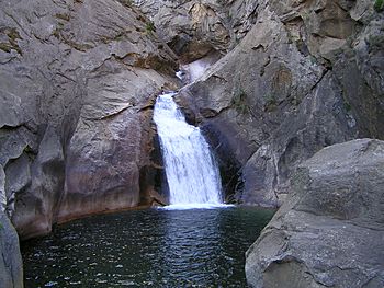
Roaring River Falls
|
|

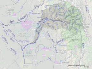
Map of the Kings River drainage basin. Roaring River joins the South Fork at right.
|
|
| Country | United States |
| State | California |
| Physical characteristics | |
| Main source | Great Western Divide 11,505 ft (3,507 m) 36°35′40″N 118°32′19″W / 36.59444°N 118.53861°W |
| River mouth | South Fork Kings River Cedar Grove 4,790 ft (1,460 m) 36°47′08″N 118°37′36″W / 36.78556°N 118.62667°W |
| Length | 16.6 mi (26.7 km) |
| Basin features | |
| Basin size | 115.2 sq mi (298 km2) |
The Roaring River is a cool river in California. It flows for about 16.6 miles (26.7 kilometers). This river is a branch of the South Fork Kings River. You can find it in the Sierra Nevada mountains, inside Kings Canyon National Park. The entire river is located within Fresno County.
About the Roaring River
The Roaring River is a beautiful natural waterway. It is known for its clear waters and the stunning landscapes it flows through. This river is a key part of the water system in the Sierra Nevada.
Where Does it Start and Go?
The Roaring River begins high up in the Great Western Divide mountains. It starts near a place called Triple Divide Peak. From there, it flows north through a valley known as Cloud Canyon.
After Cloud Canyon, the river turns northwest. It then enters Sugarloaf Valley. In this valley, another stream called Sugarloaf Creek joins the Roaring River from the west.
The Roaring River Falls
From Sugarloaf Valley, the river continues flowing north. It goes through a deep and sometimes hard-to-reach gorge. As it flows, it creates the amazing Roaring River Falls. These falls are a famous sight. The river then meets the South Fork Kings River in an area called Cedar Grove.
 | Roy Wilkins |
 | John Lewis |
 | Linda Carol Brown |

