
Sierra Nevada facts for kids
Quick facts for kids Sierra Nevada |
|
|---|---|

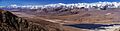
The Sierra's Mills Creek cirque (center) is on the west side of the Sierra Crest, south of Mono Lake (top, blue).
|
|
| Highest point | |
| Peak | Mount Whitney |
| Elevation | 14,505 ft (4,421 m) |
| Dimensions | |
| Length | 400 mi (640 km) north-south from Fredonyer Pass to Tehachapi Pass |
| Width | 80 mi (130 km) |
| Area | 24,370 sq mi (63,100 km2) |
| Naming | |
| Etymology | 1777: Spanish for "snowy mountain range" |
| Nickname | the Sierra, the High Sierra, Range of Light (1894, John Muir) |
| Geography | |

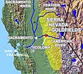
Position of Sierra Nevada inside California
|
|
| Country | United States |
| Range coordinates | 38°00′N 119°30′W / 38.000°N 119.500°W |
| Geology | |
| Age of rock | Mesozoic |
| Type of rock | batholith and igneous |
The Sierra Nevada is a large mountain range in the Western United States. It stretches between California's Central Valley and the Great Basin. Most of the range is in California, but a part called the Carson Range is mainly in Nevada. The Sierra Nevada is part of the American Cordillera, which is a long chain of mountains forming the western "backbone" of the Americas.
The Sierra is about 400 miles (640 km) long from north to south. It is between 50 miles (80 km) and 80 miles (130 km) wide. This mountain range has many amazing features. These include General Sherman, the world's largest tree by volume. It also has Lake Tahoe, North America's biggest alpine lake. Mount Whitney is here too, standing at 14,505 feet (4,421 m). It is the highest point in the contiguous United States (the lower 48 states). Yosemite Valley is another famous spot. It was shaped by glaciers from 100-million-year-old granite and has many tall waterfalls.
The Sierra is home to three national parks: Yosemite, Sequoia, and Kings Canyon National Park. It also has twenty-six wilderness areas, ten national forests, and two national monuments, like Devils Postpile National Monument.
More than 100 million years ago, during an event called the Nevadan orogeny, granite formed deep underground. The mountains began to rise less than five million years ago. Glaciers then carved out the granite, creating the light-colored mountains and cliffs we see today. This uplift created many different elevations and climates in the Sierra Nevada. This is why there are five different life zones, which are areas with similar plants and animals. The mountains are still rising today due to forces from Earth's plates. This creates dramatic cliffs along the eastern side of the southern Sierra.
The Sierra Nevada has played a big part in the history of California and the United States. The California Gold Rush happened in its western foothills from 1848 to 1855. Because it was hard to reach, the range was not fully explored until 1912.
Contents
What's in a Name?

The name "Sierra Nevada" was first used in 1542 by Juan Rodríguez Cabrillo. He used it to describe a mountain range along the Pacific Coast. Later, in 1776, Pedro Font's map gave the name to the mountains we now call the Sierra Nevada.
The name means "snowy mountains" in Spanish. Sierra means "a range of mountains" or "saw," referring to the jagged peaks. Nevada means "snowy."
Some people prefer to call the range "the Sierra" because Sierra already means "mountains" (plural) in Spanish. Adding an "s" to make it "the Sierras" is seen as incorrect by some locals. However, you might find "the Sierras" used in old books and poems.
Where is the Sierra Nevada?
The Sierra Nevada is mostly in central and eastern California. A smaller part, the Carson Range, reaches into Nevada. As you go from west to east, the elevation of the Sierra Nevada slowly rises. It goes from about 500 feet (150 m) in the Central Valley to over 14,000 feet (4,300 m) at its highest peaks in the east. The eastern side of the mountains drops steeply, forming the Sierra Escarpment. The range gets a lot of snow and rain because of how the air moves over the mountains.
Mountain Boundaries
The northern edge of the Sierra Nevada is near the Susan River and Fredonyer Pass. It's where the granite rock of the Sierra goes under younger volcanic rocks from the Cascade Range. To the west, it's bordered by California's Central Valley. To the east, it meets the Basin and Range Province. The Mojave Desert is to its southeast. The southern end of the Sierra is at Tehachapi Pass.
Rivers and Waterways

The western side of the Sierra Nevada has many rivers that flow into California's Central Valley. These rivers eventually reach the Pacific Ocean at San Francisco Bay. The northern part of the western Sierra feeds into the Sacramento River. This includes rivers like the Feather, Yuba, and American River. The middle part is drained by the San Joaquin River, with rivers like the Tuolumne and Merced River. The southern part has rivers like the Kings and Kern. These flow into Tulare Lake, which usually doesn't flow out to the ocean.
The eastern side of the Sierra has much shorter rivers. These rivers flow into the Great Basin, which is an area in eastern California and western Nevada where water doesn't reach the ocean. Rivers like the Truckee River (from Lake Tahoe) flow into Pyramid Lake. The Owens River flows into dry Owens Lake. Many streams from the southern eastern Sierra are sent into the Los Angeles Aqueduct. This aqueduct provides water to Southern California.
Mountain Heights

The mountains in the Sierra Nevada get taller as you go from north to south. In the north, peaks are usually between 5,000 feet (1,500 m) and 9,000 feet (2,700 m) high. Near Lake Tahoe, the peaks are around 9,000 feet (2,700 m).
Further south, in Yosemite National Park, Mount Lyell reaches about 13,120 feet (4,000 m). Near Bishop, California, Mount Humphreys is almost 14,000 feet (4,300 m) tall. The highest point in the entire range is Mount Whitney, near Lone Pine, California. It stands at 14,505 feet (4,421 m), making it the tallest peak in the contiguous United States.
South of Mount Whitney, the mountains quickly get lower. Near Lake Isabella, the peaks are around 10,000 feet (3,000 m). But south of that lake, they are only about 8,000 feet (2,400 m) high.
Cool Places to See

The Sierra Nevada has many famous natural spots:
- Lake Tahoe is a big, clear freshwater lake in the northern Sierra. It's at an elevation of 6,225 feet (1,897 m).
- Hetch Hetchy Valley, Yosemite Valley, Kings Canyon, and Kern Canyon are all deep canyons. Glaciers carved them out on the western side of the Sierra.
- Yosemite National Park is full of amazing sights. These include waterfalls, huge granite domes, tall mountains, lakes, and meadows.
- Groves of giant sequoias grow on the western side of the Sierra Nevada. These are the largest trees in the world by volume.
- Two of California's biggest rivers, the Sacramento River and the San Joaquin River, get most of their water from the western slopes of the Sierra Nevada. These rivers form the Central Valley and flow into San Francisco Bay.
Towns and Cities
Many communities are located in the Sierra Nevada. Some of these include South Lake Tahoe, Truckee, Mammoth Lakes, Sonora, and Auburn.
Protected Natural Areas

A large part of the Sierra Nevada is made up of federal lands. These lands are either protected from building or carefully managed. The Sierra has three National Parks: Yosemite, Kings Canyon, and Sequoia. It also has two national monuments: Devils Postpile and Giant Sequoia.
Ten national forests cover much of the rest of the mountain range. Inside these parks, monuments, and forests are 26 wilderness areas. These areas protect about 15.4% of the Sierra from logging and grazing.
The United States Forest Service and the Bureau of Land Management manage over half of the land in the Sierra Nevada. These agencies allow logging and grazing under rules that balance outdoor activities and development.
The California Bighorn Sheep Zoological Area, near Mount Williamson, was created to protect the endangered Sierra Nevada bighorn sheep.
How the Sierra Nevada Formed


The oldest rocks in the Sierra Nevada are from the Paleozoic Era. These dark-colored rocks are found in the western foothills and east of the main mountain crest. The first granite in the Sierra began to form in the Triassic period.
During the Triassic and Jurassic periods, a chain of volcanoes formed when an island arc (a curved chain of volcanic islands) crashed into the west coast of North America. This event is called the Nevadan orogeny. Most of these ancient volcanoes have since worn away.
In the Cretaceous period, a subduction zone formed. This is where an oceanic plate (a large piece of Earth's crust under the ocean) began to slide beneath the North American plate. Hot, melted rock called magma rose from deep underground. These large blobs of magma, called plutons, combined to form the Sierra Nevada batholith. These plutons formed at different times, from 115 million to 87 million years ago. The older ones formed in the western Sierra, and the newer ones formed in the eastern Sierra.
About 20 million years ago, the Earth's crust began to stretch and pull apart. This caused a lot of volcanic activity in the Sierra. Around 10 million years ago, the Sierra Nevada started to rise. A large block of Earth's crust began to tilt to the west. This happened because heat from the stretching crust made the eastern part of the block lighter. Rivers then started to cut deep canyons on both sides of the range. Lava sometimes filled these canyons.
About 2.5 million years ago, the Earth's climate got colder, and ice ages began. Huge glaciers moved through the Sierra, carving out its famous U-shaped canyons. The combination of rivers and glaciers wore away the rock, showing the granite that had formed millions of years earlier. Only small pieces of the older rocks are left on top of some Sierra peaks.
The Sierra Nevada mountains are still rising today, especially along their eastern side. This ongoing uplift can cause big earthquakes, like the 1872 Lone Pine earthquake in 1872.

Weather and Climate

The Sierra Nevada's climate is like the Mediterranean climate of California. During fall, winter, and spring, the Sierra gets a lot of rain and snow. Most of it falls as snow above 6,000 feet (1,800 m). The most precipitation happens on the western slopes, between 5,000 and 8,000 feet (1,500 and 2,400 m). This is because of something called orographic lift, where air is forced up over the mountains, cooling and dropping its moisture.
East of the main mountain crest, most areas are in a rain shadow. This means they get much less rain, usually less than 25 inches (640 mm) per year. While most summer days are dry, thunderstorms are common in the afternoon, especially in mid to late summer. These storms can bring heavy rain and lightning, which can start fires. Summer high temperatures usually range from 42 to 90 °F (6 to 32 °C). Winters are fairly mild, with temperatures just cold enough to keep a lot of snow on the ground. For example, Tuolumne Meadows, at 8,600 feet (2,600 m), has winter highs around 40 °F (4 °C) and lows around 10 °F (-12 °C). The highest parts of the Sierra have an alpine climate, which is very cold.
The snowpack in the Sierra Nevada is California's main source of water. It also helps create a lot of electric power. Many reservoirs were built in the Sierra's canyons during the 20th century. Several large aqueducts carry Sierra water to farms and cities across the state. However, the Sierra's rain shadow makes Nevada the driest state in the United States.
The amount of rain and snow can change a lot from year to year. Some years get much more or much less precipitation than usual.
The height and steepness of the Sierra Escarpment create a special wind pattern called the "Sierra Rotor." This is a spinning motion of the air just east of the Sierra's crest, caused by strong westerly winds.
The Nevada Triangle
A part of the Sierra Nevada has been called the "Nevada Triangle." This is because many airplanes have crashed there. These crashes are mainly due to the tricky weather and air conditions, like strong downdrafts (air rushing downwards) and microbursts (small, strong downdrafts) caused by the mountains. The triangle is between Reno, Nevada; Fresno, California; and Las Vegas, Nevada. Some reports say there have been 2,000 crashes in this area. There is no evidence to support any strange theories about these crashes.
Plants and Animals

The Sierra Nevada is divided into several biotic zones. Each zone has its own climate and supports different kinds of plants and animals that depend on each other. Life in the higher zones has adapted to colder weather and lots of snow. The Sierra's rain shadow makes the eastern side warmer and drier. This means each life zone is found at a higher elevation on the eastern side.
Here are some of the biotic zones and their typical elevations:
- The western foothill zone, from 1,000 to 2,500 feet (300 to 760 m). This area has grasslands, oak trees, and chaparral.
- The Pinyon pine-Juniper woodland, from 5,000 to 7,000 feet (1,500 to 2,100 m). This is found only on the east side.
- The Sierra Nevada lower montane forest, from 2,500 to 7,000 feet (760 to 2,100 m) on the west side, and 7,000 to 9,000 feet (2,100 to 2,700 m) on the east side. This zone is famous for its giant sequoia trees.
- The Sierra Nevada upper montane forest, from 7,000 to 9,000 feet (2,100 to 2,700 m) on the west side, and 9,000 to 10,500 feet (2,700 to 3,200 m) on the east side.
- The Sierra Nevada subalpine zone, from 9,000 to 10,500 feet (2,700 to 3,200 m) on the west side, and 10,500 to 11,500 feet (3,200 to 3,500 m) on the east side.
- The alpine region, above 10,500 feet (3,200 m) on the west side, and above 11,500 feet (3,500 m) on the east side. This is a very cold, treeless area.
History of the Sierra Nevada
Native American Life
Archaeological digs show that people lived in the north-central Sierra Nevada as far back as 3,000 BCE. The first known groups of Native Americans in the Sierra Nevada were the Northern Paiute tribes on the east side. On the western side were the Mono tribe and Sierra Miwok tribes. The Kawaiisu and Tübatulabal tribes lived in the southern Sierra.
Today, some old trade routes over mountain passes still show signs of these early people, like obsidian arrowheads found at Duck Pass. The Native American tribes in California and the Sierra were mostly peaceful. They sometimes had small disagreements over land between the Paiute and Sierra Miwok tribes. The Washo and Maidu also lived in this area before Europeans arrived.
Early European-American Explorers

Spanish missions and towns were built along the California coast before the 1820s. However, no Spanish explorers visited the Sierra Nevada itself. The first Americans to explore the mountains were led by fur trapper Jedediah Smith in May 1827. They crossed north of the Yosemite area.
In 1833, a group led by Joseph Reddeford Walker was sent west to find a land route to California. They found a path along the Humboldt River in present-day Nevada. They then climbed the Sierra Nevada and came down near the Tuolumne River and Merced River. This group might have been the first non-Native Americans to see Yosemite Valley. They also likely saw the giant sequoia trees.
Starting in 1841, people from the United States began moving to California through passes like Sonora Pass and Walker Pass. In the winter of 1844, Lt. John C. Frémont, with Kit Carson, was the first European American to see Lake Tahoe.
The California Gold Rush

The California Gold Rush began at Sutter's Mill, near Coloma, in the western foothills of the Sierra. On January 24, 1848, James W. Marshall found shiny metal in a lumber mill he was building. Soon, news spread, and on December 5, 1848, President James Polk confirmed the gold discovery.
Soon, many people from all over the world, called "forty-niners," rushed to the "Mother Lode" area. Miners lived in tents or small shacks. Wherever gold was found, hundreds of miners would set up camp and claim their spots.
At first, the gold was easy to find in California's rivers and streams. Miners simply panned for gold. But panning couldn't be done on a large scale. So, miners started using more complex methods like diverting entire rivers to dig for gold in the exposed riverbeds.
By 1853, most of the easy gold was gone. Miners then turned to getting gold from harder-to-reach places. Hydraulic mining was used, where powerful streams of water were aimed at gold-bearing gravel on hillsides. This method recovered huge amounts of gold. However, it also washed large amounts of gravel, dirt, and pollution into streams and rivers. Even today, many areas still show the scars of hydraulic mining, as the land cannot support plant life.
By 1855, about 300,000 gold-seekers and others had arrived in California. This huge number of newcomers pushed Native Americans out of their traditional hunting and gathering lands. To protect their homes, some Native Americans fought back, leading to conflicts.
Exploring the Mountains

Even after the Gold Rush, most of the Sierra was still unexplored by 1860. The state of California asked the California Geological Survey to explore the Sierra. Josiah Whitney led this survey. His team, including William H. Brewer and Clarence King, explored the areas that would become Yosemite National Park and Kings Canyon National Park.
In 1869, John Muir began his famous wanderings in the Sierra Nevada. By 1912, the USGS (United States Geological Survey) had published detailed maps of the Sierra Nevada. This marked the end of the main exploration era.
Logging in the Sierra

Logging in the Sierra Nevada has greatly changed the landscape. It began in the early 1800s with simple tools. The industry grew a lot during the California Gold Rush because of the high demand for wood in the mines. The Comstock Lode was a major logging center, needing wood for mine structures and fuel.
In the late 1800s, logging moved west as forests in other parts of the country were used up. New laws and financial resources helped large companies transport timber from remote areas. They built sawmills near railroad tracks, which helped send lumber across the country. New technologies, like the shay locomotive and V-shaped log flumes, made it easier to move wood through the mountains.

Protecting the Sierra

People realized early on that the Sierra Nevada was a beautiful place for tourism. Yosemite Valley was first protected by the government in 1864. John Muir saw that sheep were overgrazing and giant sequoias were being cut down. He worked hard to protect the rest of Yosemite National Park, and Congress created the park in 1890. Sequoia National Park was formed in 1906 to protect the giant sequoias, and all logging of these trees stopped then.
In 1903, the city of San Francisco wanted to build a dam to flood Hetch Hetchy Valley for water and power. After a long debate, the dam was built and finished in 1923.
Between 1912 and 1918, there were discussions about making Lake Tahoe a national park, but it didn't happen. After World War II, towns grew around the lake, affecting its clear water. Now, construction around Lake Tahoe is regulated to help keep the lake clear.
As the 20th century continued, more of the Sierra became available for outdoor activities. The John Muir Trail, a long hiking trail along the Sierra crest, was finished in 1938. Kings Canyon National Park was created in 1940 to protect the deep canyon of the Kings River.
In the 1920s, some people wanted to build more highways across the Sierra. However, the Forest Service and the Sierra Club decided that keeping parts of the Sierra wild and roadless was important. They fought against these proposals, and many wilderness areas were established to protect the Sierra's beautiful backcountry.
The Wilderness Act of 1964 protected parts of the Sierra as primitive areas. This means humans are only temporary visitors there. Today, 20 wilderness areas help protect the Sierra.
The Sierra Nevada still faces challenges. Logging continues on some lands, and overgrazing can harm the environment. There has also been an increase in large wildfires, like the Rim Fire and King Fire. Studies suggest that human-caused climate change might be increasing the risk of fires in California.
Images for kids
-
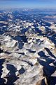
The Sierra's Mills Creek cirque (center) is on the west side of the Sierra Crest, south of Mono Lake (top, blue).
-
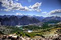
Kearsarge Lakes Basin is named after the USS Kearsarge.
-
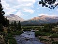
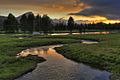
The Sierra hosts many waterways, such as the Tuolumne River.
-
Mount Whitney, the highest peak in the range and the contiguous United States.
-
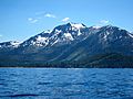
Mount Tallac above Lake Tahoe.
-
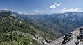
View of Sequoia National Park from Moro Rock.
-
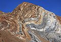
Sevehah Cliff, near Convict Lake, shows severely deformed Devonian rock.
-
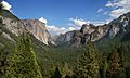
Yosemite Valley in Yosemite National Park was carved by glaciers.
-
Sierra Escarpment viewed from the east. In the foreground is Tinemaha Reservoir in the Owens Valley.
-
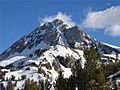
Red Slate Mountain (elevation 13,156 feet or 4,010 m) is still covered with snow in June.
-
Tuolumne Meadows is an example of a subalpine meadow in the Sierra.
-
John Frémont was an early American explorer of the Sierra.
-

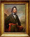
Albert Bierstadt, Among the Sierra Nevada, California, 1868.
-
Map of gold fields in the Sierra.
-
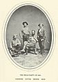
The exploration team for the California Geological Survey, 1864.
-
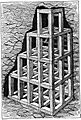
Square-set timbering as used in the Comstock mines, 1877.
-
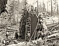
Clearcutting in Converse Basin resulted in a loss of 8,000 giant sequoia.
-
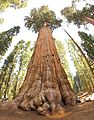
The General Sherman Tree, a giant sequoia in Sequoia National Park, is the world's largest tree by volume.

See also
 In Spanish: Sierra Nevada (Estados Unidos) para niños
