
Lake Isabella facts for kids
Quick facts for kids Lake Isabella |
|
|---|---|

Satellite image of Lake Isabella
|
|

Lake Isabella
Location in California

Lake Isabella
Location in the United States
|
|
| Location | Kern County, California, United States |
| Coordinates | 35°40′17.69″N 118°25′38.05″W / 35.6715806°N 118.4272361°W |
| Lake type | reservoir |
| Primary inflows | Upper Kern River, South Fork Kern River |
| Primary outflows | Lower Kern River |
| Basin countries | United States |
| Surface area | 11,000 acres (4,500 ha) |
| Water volume | 568,000 acre-feet (701,000 dam3) |
| Surface elevation | 2,500 ft (760 m) |
Lake Isabella, also known as Isabella Lake, is a large lake in Kern County, California. It is not a natural lake. It was created in 1953 by building a dam across the Kern River. This dam is called the Isabella Dam.
The lake covers about 11,000 acres. This makes it one of the biggest lakes in California. Lake Isabella is located in the southern part of the Sierra Nevada mountains. The lake sits at an elevation of about 2,500 feet. Summers there are hot, often over 100°F. However, it usually does not snow in winter.
Lake Isabella is about 40 miles northeast of Bakersfield, California. It provides a lot of water for Bakersfield. You can drive to Lake Isabella from Bakersfield using California State Route 178. You can also reach it from Delano, California via California State Route 155. When the lake was created, two towns were covered by water. These towns were Isabella and Kernville.
Contents
About Isabella Dam
The Isabella Dam is an important part of Lake Isabella. It helps control the water flow of the Kern River. The dam also helps to store water for the area.
Dam Safety Concerns
In 2006, engineers found a problem with the Isabella Dam. It was not strong enough to hold a full amount of water. Because of this, about 40% of the water had to be released. This was done to make the dam more stable.
Currently, the dam cannot be filled to its full capacity. It is kept at about 60% of its total volume. The U.S. Army Corps of Engineers is working on repairs. These repairs are expected to take many years. They want to make sure the dam is safe for everyone.
Engineers also found that the dam sits on an active fault line. This fault was thought to be inactive when the dam was built. They are working to make sure the dam can withstand an earthquake.
Fun Activities at Lake Isabella
Lake Isabella is a popular place for outdoor fun. The U.S. Army Corps of Engineers manages the dam. Several recreation areas are found around the lake. These areas are part of the Sequoia National Forest.
The nearby towns of Lake Isabella, California and Kernville, California benefit from visitors. People come to the area for the lake and the whitewater rafting on the Kern River. Much of the land around the lake is part of the Sequoia National Forest.
Popular Recreation Areas
- Boating and Fishing: The lake is great for boating. Many people enjoy fishing for different kinds of fish.
- Camping: There are several campgrounds around the lake. You can set up a tent or park an RV.
- Hiking: Trails near the lake offer chances to explore nature. You can see local plants and animals.
- Water Sports: On hot days, people enjoy swimming and other water sports.
Gallery

-
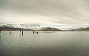
Southern shore of Lake Isabella.
-
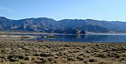
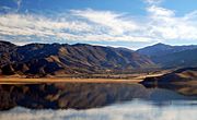
The southeast fork, viewed from the north shore with Weldon to the left.
-
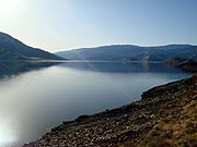
Facing west and taken from the eastern shore between the forks.
-
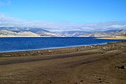
Shore near town of Lake Isabella.
-
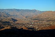
Mountain Mesa viewed from the north side of the lake.
-
View of the lake from the hills west of Bodfish.
-
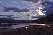
View from Pioneer Point at full moon rise


See also
 In Spanish: Lago Isabella para niños
