South Fork Kern River facts for kids
Quick facts for kids South Fork Kern River |
|
|---|---|

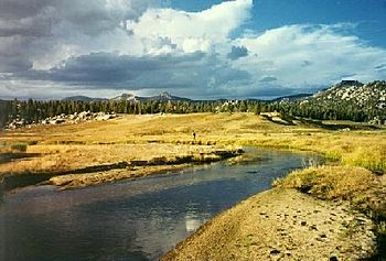
Headwaters of the South Fork Kern River in Tulare County
|
|

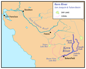
Map showing the Kern River and the South Fork Kern River (to the east of the main stem)
|
|
| Country | United States |
| State | California |
| Region | Inyo County, Tulare County, Kern County |
| Cities | Onyx, Weldon |
| Physical characteristics | |
| Main source | Southwest side of unnamed peak near Horseshoe Meadow, Inyo National Forest, Tulare County 10,850 ft (3,310 m) 36°25′55″N 118°12′48″W / 36.43194°N 118.21333°W |
| River mouth | Lake Isabella Mountain Mesa, Kern County 2,490 ft (760 m) 35°39′34″N 118°27′51″W / 35.65944°N 118.46417°W |
| Length | 95 mi (153 km), North-south |
| Basin features | |
| River system | Kern River watershed |
| Basin size | 982 sq mi (2,540 km2) |
| Tributaries |
|
The South Fork Kern River is a river in California, United States. It flows into the Kern River. This river is found in the Sierra Nevada mountains. It is one of the most southern rivers on the western side of these mountains. The river drains a high, mostly dry area called a plateau. This area covers about 982 square miles (2,540 km2) along the Sierra Crest. The upper part of the South Fork Kern River flows through rough, rocky canyons. But it also goes through a flat, marshy valley before joining the Kern River at Lake Isabella.
River's Journey: Where the South Fork Kern Flows
The South Fork Kern River starts in the Inyo National Forest. This is near the border between Inyo County and Tulare County. It begins in a small meadow on the Sierra Crest, close to the Pacific Crest Trail.
The river flows south through green meadows and wide valleys. It comes very close to Golden Trout Creek, which is another river that feeds into the Kern River. For much of its journey south, the river stays just west of Owens Valley. Owens Valley is a large, flat area at the base of the Sierra Nevada mountains to the east.
The river then enters the Sequoia National Forest. Here, it gets more water from Trout Creek, which joins it from the right. After this, the river enters a deep gorge, which is like a very narrow canyon. It flows through a canyon that is about 2,000-foot (610 m) deep.
The river then leaves the mountains near Onyx. There, it receives water from Canebrake Creek and turns southwest. The South Fork Kern River then passes through Weldon and the Kern River Preserve. As it gets closer to Lake Isabella, its fast waters slow down. They spread out into large marshy areas. The river then flows into the reservoir, forming a small delta. The place where it originally met the Kern River is now underwater because of the lake. Lake Isabella was created by the Isabella Dam.
River's Past: A Look Back in Time
Long ago, the valley of the lower South Fork Kern River was home to the Tübatulabal and Kawaiisu tribes. People have lived along this river for about 3,000 years.
In 1834, an explorer named Joseph R. Walker and his team explored the river. They were looking for an easy way to cross the Sierra Nevada mountains. During their trip, they found Walker Pass. This pass is about a mile above sea level. It is located near where Canebrake Creek begins. Canebrake Creek is an important stream that flows into the South Fork Kern River.
Walker came back in 1843, leading some of the first settlers over the Sierra Nevada using this pass. In the 1850s and 1860s, people found gold in the area. This brought many miners to the river. The first permanent towns along the river were built in 1859.
There were conflicts between the new settlers and the native tribes. To keep control, the U.S. Army set up a camp called Camp Leonard on the river.
River Changes: Dams and Roads
Most of the South Fork Kern River flows freely. This means it does not have many dams or places where water is taken out. However, there is one main exception.
In 1953, the Isabella Dam was built on the Kern River near Bodfish. The United States Army Corps of Engineers built this dam. It created Isabella Lake, which covered the lower parts of both the North Fork Kern River and the South Fork Kern River. The dam helps control floods and creates electricity.
However, there have been problems with the dam's structure. This means there is a risk that the dam could break. If the dam were to collapse, perhaps because of an earthquake on the Kern Canyon fault that runs under it, the city of Bakersfield could be flooded very quickly.
The valleys of the lower Kern, South Fork Kern, and Canebrake Creek are also important for transportation. California State Route 178 runs through these valleys. This road connects Bakersfield and Inyokern. These two towns are on opposite sides of the Sierra Nevada mountains, and the road goes through Walker Pass. State Route 178 is one of the few roads that cross this part of the mountain range. The road was first built in the 1890s. It became part of California's state highway system in 1919 and was paved in 1940.
 | Selma Burke |
 | Pauline Powell Burns |
 | Frederick J. Brown |
 | Robert Blackburn |

