Walker Pass facts for kids
Quick facts for kids Walker Pass |
|
|---|---|

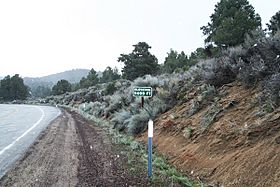
The approach to Walker Pass
|
|
| Elevation | 5,250 ft (1,600 m) |
| Traversed by | |
| Location | Sierra Crest, Kern County, California, US |
| Range | Sierra Nevada |
| Coordinates | 35°39′47″N 118°01′37″W / 35.66306°N 118.02694°W |
| Nearest city | Ridgecrest, California |
| Built | 1834 |
| NRHP reference No. | 66000210 |
| Significant dates | |
| Added to NRHP | October 15, 1966 |
| Designated NHL | July 4, 1961 |
Walker Pass is a mountain pass located near Lake Isabella in the southern Sierra Nevada mountains. It sits in northeastern Kern County, California. The pass is about 53 miles (85 km) east-northeast of Bakersfield. It is also about 10 miles (16 km) west-northwest of Ridgecrest.
This pass offers a path between the Kern River Valley and San Joaquin Valley in the west. To the east, it connects to the Mojave Desert. Walker Pass is recognized as a National Historic Landmark. It is managed by the Bureau of Land Management.
History of Walker Pass
Walker Pass was first mapped in 1834. This was done by Joseph Rutherford Walker and Garland Guthary. They were part of the Bonneville Expedition. They learned about this route from Native Americans.
Walker came back through the pass in 1843. He was leading a group of settlers in a wagon train into California. In 1845, a military survey team used the pass. This team was led by John C. Fremont. He suggested the pass be named after Walker.
The Walker Pass Lodge was built nearby in the 1930s. It was a well-known place for travelers to stop and rest. The lodge burned down around 1990. Today, the pass looks much the same as it did when Walker first mapped it in 1834. The only major change is the paved road.
What is Walker Pass Like?
Walker Pass is the highest point on State Route 178. It is also the southernmost crossing point along the Sierra Crest. The Tehachapi Pass, located further south, usually marks the border between the Sierra Nevada and Tehachapi Mountains.
Between Walker Pass and Tioga Pass to the north, there is only one paved road that crosses the Sierra Nevada. This road runs from the northern end of Indian Wells Valley in the east. It then goes west along the Sherman Pass Road.
Many roads in the Sierra Nevada close during winter due to heavy snow. This includes roads between Walker Pass and Carson Pass (State Route 88), which are over 200 miles (320 km) apart. Walker Pass sometimes closes because of snow. However, because it is at a lower elevation, these closures are usually short. Most east-west traffic in this area uses State Route 58. This four-lane road goes through Tehachapi Pass, about an hour's drive to the south.
The famous Pacific Crest Trail also crosses at Walker Pass. There is a campsite about 0.6 miles (1 kilometer) southwest of the road pass. This spot is popular with hikers and people who enjoy looking at the stars.
Walker Pass: A Special Historical Place
Walker Pass is recognized as a California Historical Landmark. This means it's a very important place in California's history. The official marker at the pass says:
- NO. 99 WALKER'S PASS - Discovered by Joseph R. Walker, an American trailblazer. He left the San Joaquin Valley through this pass in 1834. This area was explored by Edward M. Kern, a mapmaker. The Kern River is named after him. He was with the Frémont expedition in 1845. After 1860, the pass became a route for mining supplies to Owens Valley.*
 | William L. Dawson |
 | W. E. B. Du Bois |
 | Harry Belafonte |


