
Tehachapi Mountains facts for kids
Quick facts for kids Tehachapi Mountains |
|
|---|---|

Tehachapi Mountains Crest peaks
|
|
| Highest point | |
| Peak | Double Mountain |
| Elevation | 7,981 ft (2,433 m) |
| Dimensions | |
| Length | 40 mi (64 km) |
| Geography | |
 |
|
| Country | United States |
| Range coordinates | 34°57′N 118°35′W / 34.95°N 118.58°W |
| Parent range | Transverse Ranges |
The Tehachapi Mountains are a mountain range in California, USA. They are part of the Transverse Ranges system. These mountains stretch for about 40 miles (64 km) across parts of Kern and Los Angeles counties. They act like a natural border between the San Joaquin Valley and the Mojave Desert.
Contents
Exploring the Tehachapi Mountains
The Tehachapis are a natural barrier. They separate the San Joaquin Valley to the northwest from the Mojave Desert to the southeast. The mountain tops range from about 4,000 to 8,000 feet (1,200 to 2,400 meters) high.
These mountains are southeast of Bakersfield and the Central Valley. They are west of Mojave and the Antelope Valley. The range connects the southern Sierra Nevada mountains in the northeast with the San Emigdio Mountains in the west. It also connects with the Sierra Pelona Mountains in the southwest.
Important Mountain Passes
The Tehachapis are separated from other mountain ranges by special passes:
- Tejon Pass: This pass separates the Tehachapis from the San Emigdio Mountains. Interstate 5 climbs steeply here from the San Joaquin Valley. People often call this part of the highway "The Grapevine." It got its name from wild grapevines that grow in the canyon.
- California State Route 138: This road separates the Tehachapis from the Sierra Pelona Mountains. It connects Interstate 5 with the Antelope Valley.
- Tehachapi Pass: This pass separates the Tehachapis from the Sierra Nevada. State Route 58 crosses here. The Union Pacific train line also crosses this pass. It includes the famous Tehachapi Loop, a special spiral track. The Tehachapi Pass Wind Farm is also located on the eastern side of this pass.
The Tehachapi Mountains are not as long or high as some other California ranges. However, they are often seen as the natural dividing line between Northern California and Southern California.
How the Tehachapis Were Formed
The Tehachapi Mountains were mostly formed by the movement of the Garlock Fault. This is a major fault line located along the southeastern base of the range. The Garlock Fault is a special type of fault called a "left-lateral fault." This means that if you stand facing the fault, the land on the other side moves to the left. This is different from most faults in California, where the land moves to the right.
Nature and Wildlife in the Tehachapis


The Tehachapi Mountains are a very important wildlife corridor. This means they act like a bridge for animals and plants. They connect the Transverse Ranges and the California Coast Ranges in the west with the Sierra Nevada in the east. Because much of the land, especially the large Tejon Ranch, has not been developed, these natural connections are still strong.
Plants of the Tehachapis
The Tehachapis are mostly covered in California interior chaparral and woodlands. This means you'll find native grasslands, California oak woodlands, and oak savanna. At higher elevations, you'll see California mixed evergreen forests.
Some common trees and plants include:
In the higher mountain areas, you might find:
- Black oak
- Coulter pine
- Incense cedar
- White fir
- In a few hidden spots, small groups of quaking aspen trees.
Some unique plants grow only in the Tehachapi Mountains:
- The Tehachapi linanthus is a phlox plant found only here and in the southern Sierra Nevada.
- The Tehachapi ragwort is an aster plant found only in the Tehachapis and eastern Transverse Ranges.
- The Tehachapi buckwheat is known only from the chaparral of the Tehachapis.
Animals of the Tehachapis
The Tehachapi Mountains are home to some special animals:
- The Tehachapi slender salamander lives only here and is a vulnerable species.
- The white-eared pocket mouse is found only in the Tehachapis and San Bernardino Mountains and is an endangered species.
Over 100 types of birds live in the Tehachapis, including the Steller's jay and mountain chickadee. Many of these birds eat acorns from black oak trees.
A very important bird of prey here is the California condor. It is a critically endangered species.
Larger animals you might see include:
The Tehachapi Mountains were also the last known place where jaguars lived and had babies in the United States. Jaguars were seen here as recently as the late 1800s.
Climate in the Tehachapis
The Tehachapi Mountains are a border between two main climate zones: the dry Mojave Desert and the Mediterranean climate zone. Most of the range is in the Mediterranean climate zone. This means it gets rain in the winter, similar to other nearby mountains.
The mountains create a "rain shadow" effect. This means the eastern side, facing the Mojave Desert, gets very little rain, usually only a few inches a year. In summer, higher parts of the range might get some rain from monsoon storms. The wettest slopes get about 20–25 inches (50–63 cm) of rain each year, sometimes as snow.
Winds usually blow from the northwest. They funnel through the canyons and passes of the Tehachapi range. This is why the Tehachapi Wind Resource Area with its many wind turbines exists here.
History of the Tehachapi Region

The name "Tehachapi" might come from the Kawaiisu language. It means "hard climb."
Native Peoples of the Tehachapis
Long ago, these Indigenous peoples of California lived in the Tehachapi Mountains:
Historic Ranchos and Sites
Large land grants called "ranchos" were given out in the Tehachapis during Mexican rule. These included:
- Rancho El Tejon (1843)
- Rancho Castac (1843)
- Rancho La Liebre (1846)
- Rancho Los Alamos y Agua Caliente (1846)
These four ranchos were bought by Edward Fitzgerald Beale between 1855 and 1866. They became known as the Tejon Ranch. Today, Tejon Ranch is still one of the largest privately owned lands in California.
Other important historical places in the Tehachapi area include:
- Oak Creek Pass: An old Native American trail. Francisco Garcés was the first European to use it in 1776.
- Fort Tejon: A fort built in 1854. It is now a State Historic Park.
- 1857 Fort Tejon earthquake: A very strong earthquake that happened in 1857.
- Monolith Cement Works: A factory that made concrete for big projects like the Hoover Dam.
- Old Tejon Pass: Another ancient Native American trail.
Tallest Peaks in the Tehachapis
Here are some of the highest points in the Tehachapi Mountains:
- Double Mountain 7,981 ft (2,433 m)
- Tehachapi Mountain 7,960+ ft (2,426+ m)
- Cummings Mountain 7,760+ ft (2,365+ m)
- Bear Mountain 6,920+ ft (2,109+ m)
- Black Mountain 5,686 ft (1,733 m)
- Grapevine Peak 4,815 ft (1,468 m)
Images for kids
-
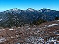
Tehachapi Mountains Crest peaks
-
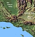
Map of the Tehachapi Mountains
-
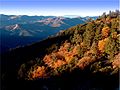
The California mixed evergreen forest plant community in the upper Tehachapi Mountains
-
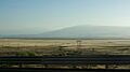
View of the Tehachapi Mountains from I-5 as it descends into the Central Valley.
-
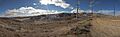
The eastern Tehachapi foothills: panoramic view with the Tehachapi Pass Wind Farm.
See also
 In Spanish: Sierra de Tehachapi para niños
