Transverse Ranges facts for kids
Quick facts for kids Transverse Ranges |
|
|---|---|
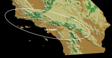
The ellipse outlines the region of the California Transverse Ranges
|
|
| Highest point | |
| Peak | San Gorgonio Mountain |
| Elevation | 11,503 ft (3,506 m) |
| Dimensions | |
| Length | 300 mi (480 km) |
| Geography | |
| Country | United States |
| Parent range | Pacific Coast Ranges |
The Transverse Ranges are a special group of mountains in southern California. They are part of the larger Pacific Coast Ranges in North America. These mountains are unique because they run from east to west. Most other mountain ranges in California go from northwest to southeast.
The Transverse Ranges start near Point Conception and stretch about 500 kilometers (300 miles) eastward. They reach into the Mojave and Colorado Desert. These ranges cross several counties, including Santa Barbara, Ventura, Los Angeles, San Bernardino, Riverside, and Kern.
The mountains are divided into three main parts: western, central, and eastern. Each part has different types of rocks, elevations, and plants. The central and eastern parts, especially near the San Andreas Fault, have the highest peaks.
Most of the Transverse Ranges are covered in California chaparral and woodlands. Lower areas have chaparral and scrubland plants. Higher up, you'll find large conifer forests. These mountains were mostly formed by fault blocks, which means huge pieces of the Earth's crust moved and pushed them up. This happened during the Cenozoic Era, which was a long time ago.
Contents
Exploring the Transverse Ranges Geography
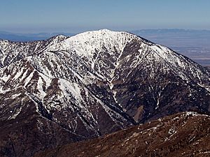
The Transverse Ranges are bordered by the San Andreas Fault to the north and east. This fault separates them from the Mojave Desert. To the south and west, the Pacific Ocean and the northern Channel Islands form their boundaries. The Los Angeles Basin is also along their southern edge.
These mountains look like many parallel ridges, usually between 3,000 and 8,000 feet (900-2,400 meters) high. Many small, steep streams cut through them. Because of this, the mountains have a very rugged landscape. There are not many large flat areas, except for some valleys like the San Fernando Valley.
It can be tough to travel through these mountains because they are so steep. There are only a few passes that are low or wide enough for a lot of traffic. This means that major cities often rely on just a few roads to connect with the rest of California. For example, most traffic between the Central Valley and Los Angeles goes through Tejon Pass. This can cause big traffic jams if a pass closes due to snow or construction. Sometimes, cities like Santa Barbara can even be cut off from road access.
Highest Peaks in the Transverse Ranges
Here are some of the tallest peaks in the Transverse Ranges. They are listed by their height:
- Mount San Gorgonio, 11,503 ft (3,506 m), San Bernardino Mountains.
- Anderson Peak, 10,840 ft (3,304 m), San Bernardino Mountains.
- Mount San Antonio (Old Baldy), 10,068 ft (3,069 m), San Gabriel Mountains.
- Sugarloaf Mountain, 9,952 ft (3,033 m), San Bernardino Mountains.
- Mount Baden-Powell, 9,407 ft (2,867 m), San Gabriel Mountains.
- Galena Peak, 9,324 ft (2,842 m), San Bernardino Mountains.
- Throop Peak, 9,142 ft (2,786 m), San Gabriel Mountains.
- Telegraph Peak, 8,985 ft (2,739 m), San Gabriel Mountains.
- Cucamonga Peak, 8,862 ft (2,701 m), San Gabriel Mountains.
- Mount Pinos, 8,847 ft (2,697 m).
- Ontario Peak, 8,693 ft (2,650 m), San Gabriel Mountains.
- Delamar Mountain, 8,402 ft (2,561 m), San Bernardino Mountains.
- Cerro Noroeste, 8,280 ft (2,524 m).
- Mount Islip, 8,254 ft (2,516 m), San Gabriel Mountains.
- Gold Mountain, 8,239 ft (2,511 m), San Bernardino Mountains.
- Bertha Peak, 8,205 ft (2,501 m), San Bernardino Mountains.
- Frazier Mountain, 8,017 ft (2,444 m).
- Iron Mountain #1, 8,010 ft (2,441 m), San Gabriel Mountains.
- Reyes Peak, 7,510 ft (2,289 m), Pine Mountain Ridge.
- Haddock Mountain, 7,431 ft (2,265 m), Pine Mountain Ridge.
Mountain Ranges by Segment
The Transverse Ranges are divided into three main sections:
Western Segment Mountains
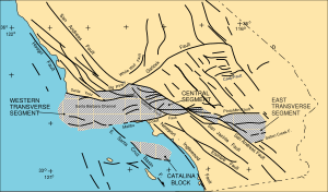
This part starts at Point Conception. It includes the Santa Ynez Mountains near Santa Barbara. Other ranges here are the Topatopa Mountains, Santa Susana Mountains, Simi Hills, and Santa Monica Mountains. The Santa Monica Mountains run along the coast near Malibu, with the Hollywood Hills being their eastern part. The northern Channel Islands (San Miguel, Santa Rosa, Santa Cruz, and Anacapa) are also part of this western segment.
Central Segment Mountains
This section includes the steep San Gabriel Mountains northeast of Los Angeles. You'll also find the Tehachapi Mountains southeast of Bakersfield, the Verdugo Mountains, and the Puente Hills.
Eastern Segment Mountains
The eastern part includes the San Bernardino Mountains, Little San Bernardino Mountains, Pinto, Eagle, and Orocopia Mountains. The Mojave Desert and Coachella Valley are at the eastern end of these ranges.
Some other nearby ranges, like the San Rafael Mountains and Sierra Madre Mountains, are almost east-west but are part of the California Coast Ranges. The Tehachapi Mountains are the southern end of the Sierra Nevada.
|
Mountain ranges with peaks over 4,500 feet (1,370 m), from west to east: |
Examples of smaller mountains and hills: |
Climate in the Mountains
Most of the Transverse Ranges have a Warm-summer Mediterranean climate. This means they have hot, dry summers and mild, wet winters. The very top of San Gorgonio Mountain has an alpine tundra climate, which is very cold. The lower northern slopes are drier, like a desert or steppe.
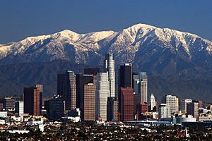
Snow usually falls above 6,000 feet (1,800 m) every winter. It can also snow above 3,000 feet (900 m) every few years. Even during dry years, snow almost always falls above 8,000 feet (2,400 m). Because the air isn't very humid, snow doesn't stay on the ground all year, except for small patches. The tree line, where trees stop growing due to cold, is around 11,000 feet (3,350 m). San Gorgonio Mountain is the only peak high enough to have this kind of environment.
How the Transverse Ranges Formed: Geology
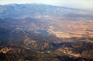
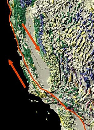
The Transverse Ranges were formed by the powerful forces of plate tectonics. This happens where the Pacific Plate and the North American Plate rub against each other along the San Andreas Fault. The unique east-west direction of these mountains is because the San Andreas Fault takes a sharp left turn here. As the Pacific Plate moves northwest, the crust gets squeezed and pushed up, creating the mountains.
Before this big bend formed about 4 million years ago, the rocks in the Transverse Ranges started to rotate clockwise. This rotation is still happening today. The western ranges have rotated about 90 degrees, while the eastern ranges have rotated about 40 degrees. Catalina Island has rotated the most, nearly 120 degrees!
Types of Rocks in the Mountains
The rocks in the Transverse Ranges are very different in age and type. In the western part, you'll find sedimentary rocks (like sandstone) and volcanic rocks. In the central and eastern parts, there are mostly granitic and metamorphic rocks, like those in the San Gabriel and San Bernardino Mountains.
The oldest rocks, from the Proterozoic age, are found deep within the San Gabriel and San Bernardino Mountains. Younger rocks, including granites, are found east of Tejon Pass. The newest rocks are from the Cenozoic Era and include sedimentary and volcanic rocks found throughout the ranges.
The western part of the ranges has very thick layers of sedimentary rocks, up to 10 kilometers (6 miles) deep. These rocks formed mostly in the ocean, but some are "red beds" from ancient river systems.
Major Fault Lines
A key feature of the Transverse Ranges is that they are surrounded by faults that run east-west. Most of these are strike slip faults, where the land moves sideways. In the western and central parts, many are also thrust faults, where one block of land is pushed over another.
Because these faults are active and cause earthquakes, and they don't cut through each other, scientists believe the east-west faults and the Transverse Ranges are rotating clockwise.
Important faults include the Malibu Coast—Santa Monica—Hollywood fault to the south of the western segment. To the north, there are the Santa Ynez Fault and Pine Mountain Faults. The San Gabriel Fault and San Andreas Fault border the central segment. The eastern segment is bordered by the Pinto Mountain Fault and the Salton Creek Fault.
Oil in the Mountains
The thick layers of ocean sediments in the western Transverse Ranges have created a lot of oil. Many oil fields are found both on land and offshore, especially in the Santa Barbara Channel. Much of this oil is trapped in the Monterey Formation. The Los Angeles Basin, south of the western ranges, also has a lot of oil. California is one of the most important oil-producing areas in the United States because of these folded and faulted sedimentary rocks.
Nature and Wildlife: Ecology
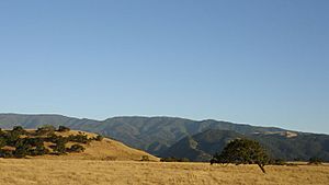
The plants in the Transverse Ranges vary a lot. At lower elevations, you'll see coastal sage scrub, oak woodlands, and pinyon-juniper woodlands. Higher up, there are yellow pine forests, Lodgepole Pines, and subalpine forests. The Angeles National Forest and Los Padres National Forest cover parts of these mountains.
The ranges are part of the California chaparral and woodlands area. Chaparral is a common type of shrubland here. Plants like California sagebrush and Toyon are often found in chaparral areas.
Pinyon-juniper woodlands are common on the northern slopes of the San Gabriel and San Bernardino Mountains. You can easily see this type of forest near Soledad Pass, between Pearblossom and Santa Clarita.
Impact of Cities
Many cities and towns are located in the plains and valleys between the Transverse Ranges. These include the Oxnard Plain in Ventura County, the Santa Clarita Valley, and the San Fernando Valley (which is mostly part of Los Angeles). The Los Angeles Basin, which includes parts of Los Angeles County and Orange County, and the Inland Empire (with cities like San Bernardino and Riverside) are also found between the Transverse Ranges and the Peninsular Ranges to the south.
Getting Around: Transportation
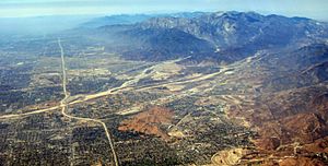
Several important freeways cross the Transverse Ranges. These include (from west to east) US-101, I-5 at Tejon Pass, SR 14 at Soledad Pass, and I-15 at Cajon Pass. These highways connect Southern California to places like San Francisco and Las Vegas.
Most of these passes are not very high. For example, Cajon Pass is only about 4,190 feet (1,277 m) above sea level. This means snow is less of a problem here compared to higher mountain passes further north. However, heavy snowfall can still cause traffic issues on Tejon and Cajon Pass. Also, I-5 and I-15 often have heavy traffic as they cross these mountains.
|
See also
 In Spanish: Cordilleras transversales para niños
 | Emma Amos |
 | Edward Mitchell Bannister |
 | Larry D. Alexander |
 | Ernie Barnes |


