
Oxnard Plain facts for kids
The Oxnard Plain is a big, flat area of land right next to the ocean in Ventura County, California. It's surrounded by mountains like the Transverse Ranges. Many cities and towns are located here, including Oxnard, Camarillo, Port Hueneme, and parts of Ventura. This plain covers more than 200 square miles (518 square kilometers).
The Oxnard Plain is a great place for farming. It has rich soil, enough water, good weather, and a long growing season. Farmers here grow lots of strawberries, raspberries, plants for nurseries, and celery. Ventura County is one of California's top farming areas, and agriculture is a huge part of its economy. People in the area really want to keep these farmlands, and they've voted for rules to protect them.
This plain was mostly formed by dirt and sand carried by the Santa Clara River and Calleguas Creek. Before farming grew, the area had many marshes, salty flats, and lagoons. The Santa Clara River is one of the biggest rivers in Southern California that still flows naturally, without being changed by concrete channels. The Oxnard Plain faces the Santa Barbara Channel and stretches from Point Mugu in the south to the Ventura River in the north. You can also see Conejo Mountain and Boney Peak nearby.
The Oxnard Plain also has oil underground. There are several active oil fields, like the Oxnard Oil Field, and some smaller ones that are no longer used. You might see oil facilities mixed in with the farms around Oxnard.

Contents
A Look Back in Time
Early People and History
People have lived along this coast for a very long time, even before 5000 B.C.E. We know this from old sites that show where they lived, made tools, and buried their dead. The area had many natural resources and good weather, which made it a great place for people to settle. Native American villages were common along Calleguas Creek and the Santa Clara River. Many old sites are also found near Mugu Lagoon and in the nearby Santa Monica Mountains. These sites are often close to water sources, which were very important for survival. Over time, farming and other activities have changed some of these ancient sites.
Spanish Rule (1782 to 1822)
Spanish explorers sailed along the California coast starting in the 1500s. In the 1700s, Spain began to settle California. They built missions, forts (called presidios), and towns. Mission San Buenaventura was founded in 1782, about 10 miles (16 km) from the Santa Clara River.
The Oxnard Plain was used for grazing large herds of animals like cattle and sheep by the missions. This changed the traditional way of life for the Chumash people, who were the native inhabitants. More Europeans and Americans also came to the coast to trade for animal furs and hides. The large number of mission animals damaged the land and made it harder for the Chumash to find their traditional foods. This led many Chumash people to join the missions. The Chumash population also decreased a lot due to many complex reasons.
Mexican Rule (1822-1848)
Mexico became independent from Spain in 1821. The Mexican government then closed the missions in 1836 and gave their lands away as large farms called ranchos. This opened up the Oxnard Plain for more European settlement.
In 1848, the United States took control of California after the Mexican–American War. California became the 31st state in 1850. Many Mexican residents and European immigrants living here became U.S. citizens.
Early European Settlers
Between 1848 and 1855, cattle ranching was very profitable because of the California Gold Rush. But a big drought in 1863 caused cattle ranching to decline sharply.
New settlers started arriving. James Saviers bought land in 1862 and grew eucalyptus trees to protect crops from strong, dry winds. In 1867, Gottfried Maulhardt and Christian Borchard started farming wheat and barley. A shipping wharf was built in Hueneme in 1871, which helped farmers sell their grain. Irish and German immigrants also came to farm. Lima beans later became the main crop, but farmers also tried growing sugar beets in 1897. The community of New Jerusalem, later called El Rio, was founded in 1875 along the Santa Clara River.
.jpg)
Geography of the Plain
The Oxnard Plain is surrounded by the Santa Monica Mountains, the Santa Susana Mountains, and the Topatopa Mountains. To the northeast is the Santa Clara River Valley, and to the south and west is the Santa Barbara Channel. The land here is mostly flat.
It was formed by dirt and sand brought down by the Santa Clara River and Calleguas Creek as they flow into the Pacific Ocean. These layers of dirt are usually about 100 feet (30 meters) thick. The Santa Clara River is special because it's one of the few rivers in Southern California that still flows naturally, without being put into concrete channels.
Before farming became widespread, this flat coastal area had many marshes, salty flats, and lagoons. Historically, floods from Calleguas Creek spread dirt across the plain, creating the rich farmland we see today. Now, with farming happening all year, concrete channels and dirt walls have been built to control the water flow. This has led to more dirt being carried into Mugu Lagoon and can cause flooding during very heavy rains. The coastline here is very developed, with the Port of Hueneme, Channel Islands Harbor, and Ventura Harbor, along with many structures like breakwaters and jetties.
Water for the Plain

Sometimes, ocean water can seep into the underground water supply in the southern Oxnard Plain. This happens because too much groundwater is pumped out. In the past, farmers used ditches to get water from the Santa Clara River. Later, they started pumping water from underground. Today, much of this underground water can't be used for farming or drinking because it has become too salty. Unlike some other coastal areas, Ventura County doesn't have a barrier to stop ocean water from getting into its underground water sources.
In 2014, a new law called the Sustainable Groundwater Management Act was passed in California. This law helps local areas manage their groundwater in a sustainable way. Because of this, Ventura County stopped new well-drilling in the Oxnard Plain for a while. During the drought from 2012 to 2015, groundwater levels went down.
- Calleguas Municipal Water District
This water company provides water to about 75% of Ventura County's people. Calleguas brings water from northern California to cities on the Oxnard Plain like Oxnard, Port Hueneme, and Camarillo, as well as other areas. These areas also use local groundwater, but it can be salty. The salt comes from farming, industries, homes, and even the imported water.
Many local water agencies are building special plants called desalters to treat salty groundwater. These plants use a process called reverse osmosis to remove the salt. The clean water can then be used for drinking, which means the region won't have to rely as much on imported water. The leftover salty water is sent out to sea through a big pipeline project called the Calleguas Regional Salinity Management Project.
- Camarillo and Santa Rosa Valley
The city of Camarillo gets about 60% of its water from the state water project and 40% from its own wells. Camarillo is building a new desalter plant to treat salty well water.
The Camrosa Water District serves nearly 30,000 people in Camarillo and the Santa Rosa Valley. In 2015, Camrosa finished building its own desalting plant, which cleans up salty groundwater and provides drinking water.
- Oxnard
In 2008, the city of Oxnard opened a plant that treats salty groundwater. Oxnard also built a larger Advanced Water Purification Facility (AWPF) for $71 million. This plant cleans treated wastewater to a very high level. This super-clean water can be used for crops, by businesses, and for watering parks and landscaping. It can also be put back into the ground to be pumped out later for drinking.
Since 2015, this clean water has been used to water a golf course. Slowly, pipelines are being built to bring this water to city parks, street medians, and new housing developments. It's also provided to businesses and farmers near the plant.
- United Water Conservation District
This district helps manage groundwater by refilling underground water sources and providing other water supplies. It owns Lake Piru and other facilities on the Santa Clara River that help manage water. The district delivers water through pipelines to different parts of the Oxnard Plain, including Oxnard, Port Hueneme, and agricultural areas.
The Vern Freeman Diversion Dam, built by United Water in 1991 on the Santa Clara River, sends water to shallow basins. These basins help refill the underground water supply. Before this dam, temporary dirt dams were built in the river to get water for farmers and refill the ground. But these dirt dams had to be rebuilt after heavy rains.
In 1997, Steelhead trout were declared endangered. The fish ladder on the Vern Freeman Dam was not good enough for them to migrate. Fixing this ladder became a high priority to help the steelhead move from the ocean up the river.
In 2019, United Water released water from Lake Piru specifically to help refill the Fox Canyon underground water source in the Oxnard Plain.
Ormond Beach

Ormond Beach is a large, flat coastal area on the south side of the Oxnard Plain, covering about 1,500 acres (607 hectares). Historically, it had marshes, salt flats, and lagoons. Over the last century, farming and industry have drained and filled many of these wetlands. However, there is still a special area with dunes, a transition zone, and marshes along about 2 miles (3 km) of beach, stretching from Port Hueneme to the Point Mugu Naval Air Station.
Hazards
The coastline of the Oxnard Plain can be affected by a tsunami (a very large ocean wave) up to 23 feet (7 meters) high.
Images for kids
-
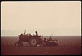
Oxnard Plain, 1975
-
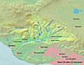
Santa Clara river watershed


