Port Hueneme, California facts for kids
Quick facts for kids
Port Hueneme, California
Hueneme
|
||
|---|---|---|
| City of Port Hueneme | ||
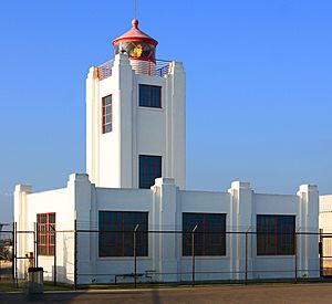
Point Hueneme Light
|
||
|
||
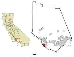
Location in Ventura County
|
||
| Country | United States | |
| State | California | |
| County | Ventura | |
| Wharf constructed | 1871 | |
| Street grid established | October 1, 1888 | |
| Incorporated | March 24, 1948 | |
| Government | ||
| • Type | Council-mayor | |
| Area | ||
| • Total | 4.67 sq mi (12.09 km2) | |
| • Land | 4.42 sq mi (11.44 km2) | |
| • Water | 0.25 sq mi (0.65 km2) 4.70% | |
| Elevation | 13 ft (4 m) | |
| Population
(2020)
|
||
| • Total | 21,954 | |
| • Density | 4,701/sq mi (1,815.9/km2) | |
| Time zone | UTC-8 (Pacific) | |
| • Summer (DST) | UTC-7 (PDT) | |
| ZIP codes |
93041–93044
|
|
| Area code | 805 | |
| FIPS code | 06-58296 | |
| GNIS feature ID | 1652778 | |
Port Hueneme (say "wy-NEEM-ee") is a small beach city in Ventura County, California. It is surrounded by the city of Oxnard and the Santa Barbara Channel. Both the Port of Hueneme and Naval Base Ventura County are located within the city.
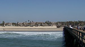
Port Hueneme has a sandy beach that faces south. It is well-known for its surfing waves. The beach also has a wooden fishing pier. It stretches for about a mile between Ormond Beach and the Point Hueneme Light. This lighthouse is at the entrance to the harbor, which is shared by the naval base and the port. The Waterfront Promenade is a paved path along the shoreline. It offers public access and views of two historic sites: the 1872 Wharf and the Oxnard Packing House.
Contents
About the Name of Hueneme
The name Hueneme comes from the Spanish spelling of Wene Me. This is a word from the Ventureño Chumash language. It means "Resting Place." In the 1800s, the local postmaster named the post office Wynema. This was after his company, Wynema Lighter Co. The town's name was officially changed to Port Hueneme in 1939. It became an official city on March 24, 1948.
In July 2021, the city council thought about changing the city name to Hueneme Beach. They wanted to attract more tourists and new businesses. This idea was voted down in November 2022.
History of Port Hueneme
The explorer Juan Rodríguez Cabrillo explored this area in October 1542. He also explored the nearby Channel Islands.
Thomas Bard discovered a deep underwater canyon at Point Hueneme. He used this deep water to build the Hueneme Wharf in 1871. The streets of the town were officially planned out in 1888. The wharf was the main way to transport goods for this part of Ventura County. This was true until the railroad came to nearby Oxnard. Between 1871 and 1895, Hueneme was the second largest grain shipping port on the Pacific coast.
A pier was built in 1956. It was originally 650-foot-long (200 m) and used for a sewer pipeline. Today, the fishing pier is 1,250 feet (380 m) long. It has been changed and improved over the years.
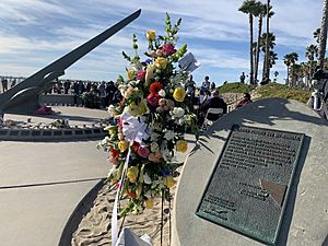
On January 31, 2000, Alaska Airlines Flight 261 crashed into the Pacific Ocean. This happened between Port Hueneme and Anacapa Island. The U.S. Navy Base Ventura County helped recover the wreckage. A memorial sundial was built on the beach near the crash site. It was designed by artist James "Bud" Bottoms. The names of the victims are on bronze plates around the sundial. Every January 31, at 4:22 PM, the sundial casts a shadow on a special memorial plaque.
Geography and Climate
Port Hueneme is located on the southwest part of the Oxnard Plain. It sits right on the Pacific Ocean.
The city covers about 4.7 square miles (12.1 square kilometers). Most of this area is land, and a small part is water.
Local Climate
Port Hueneme has warm, dry summers. The average monthly temperatures do not go above 71.6°F (22°C). This type of weather is called a warm-summer Mediterranean climate.
| Climate data for Port Hueneme, California | |||||||||||||
|---|---|---|---|---|---|---|---|---|---|---|---|---|---|
| Month | Jan | Feb | Mar | Apr | May | Jun | Jul | Aug | Sep | Oct | Nov | Dec | Year |
| Mean daily maximum °F (°C) | 64.7 (18.2) |
64.7 (18.2) |
64.8 (18.2) |
66.0 (18.9) |
67.6 (19.8) |
69.6 (20.9) |
72.7 (22.6) |
73.1 (22.8) |
73.2 (22.9) |
71.9 (22.2) |
68.7 (20.4) |
65.0 (18.3) |
68.5 (20.3) |
| Mean daily minimum °F (°C) | 45.5 (7.5) |
46.4 (8.0) |
47.9 (8.8) |
49.0 (9.4) |
52.7 (11.5) |
56.2 (13.4) |
59.0 (15.0) |
59.2 (15.1) |
57.8 (14.3) |
54.0 (12.2) |
48.7 (9.3) |
44.8 (7.1) |
51.8 (11.0) |
| Average precipitation inches (mm) | 3.44 (87) |
3.93 (100) |
3.06 (78) |
0.74 (19) |
0.21 (5.3) |
0.05 (1.3) |
0.02 (0.51) |
0.07 (1.8) |
0.35 (8.9) |
0.39 (9.9) |
1.33 (34) |
2.11 (54) |
15.71 (399) |
Population and People
| Historical population | |||
|---|---|---|---|
| Census | Pop. | %± | |
| 1880 | 166 | — | |
| 1950 | 3,024 | — | |
| 1960 | 11,067 | 266.0% | |
| 1970 | 14,295 | 29.2% | |
| 1980 | 17,803 | 24.5% | |
| 1990 | 20,319 | 14.1% | |
| 2000 | 21,845 | 7.5% | |
| 2010 | 21,723 | −0.6% | |
| 2020 | 21,954 | 1.1% | |
| U.S. Census Burea | |||
Population in 2010
The 2010 United States Census showed that Port Hueneme had 21,723 people. About 96% of the people lived in homes.
The population included many different groups. About 57% were White, and 5.1% were African American. Around 6% were Asian, and 1.4% were Native American. About 24% were from other races, and 6.1% were from two or more races. Over half of the people, about 52.3%, were Hispanic or Latino.
There were 7,080 households in the city. About 40% of these households had children under 18 living there. The average household had about 2.95 people. The average family size was 3.52 people.
The population had a mix of ages. About 26.6% were under 18 years old. Around 28.8% were between 25 and 44 years old. About 11% of the people were 65 years or older. The average age in the city was 31.3 years.
Population in 2000
In the year 2000, there were 21,845 people living in Port Hueneme. There were 7,268 households and 5,000 families. The population density was about 4,913 people per square mile.
The racial makeup was similar to 2010. About 57% were White, and 6% were African American. Around 6.3% were Asian, and 1.7% were Native American. About 21.8% were from other races. Over 41% of the population was Hispanic or Latino.
About 37.4% of households had children under 18. The average household size was 2.86 people. The average family size was 3.42 people.
The population was spread out by age. About 27.6% were under 18. Around 32% were between 25 and 44 years old. About 10.7% were 65 or older. The average age was 30 years.
Economy of Port Hueneme
The main business area is on Channel Islands Boulevard. This area is separated from the old downtown by the Naval base.
The Port of Hueneme
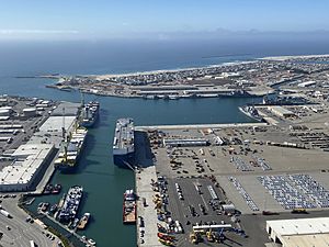
The Port of Hueneme is very important. It is the only deep water port between the Los Angeles and the San Francisco. It is also the only Navy-controlled harbor between San Diego Bay and Puget Sound, Washington.
The harbor is a busy place for shipping and receiving goods. These goods go to the Los Angeles Basin and other places. Things like cars, pineapples, and bananas come through this port. Farm products such as onions, strawberries, and flowers are also shipped from here. The city gets about $2 million in tax money each year from the port.
For 60 years, the beach at Port Hueneme has been losing sand. This is because the port's jetties block the natural flow of sand. After the U.S. Navy took over the port during World War II, the government became responsible for replacing the lost sand. In 2013, nearly $12 million was given to add sand back to the beach. This money came from different government groups. Also, there is an ongoing effort to stop ocean water from flooding city streets.
Arts and Culture
Hueneme Beach Festival
Since 1998, Port Hueneme has held an annual beach festival. This event takes place at 550 East Surfside Drive. It is a 2-day festival held in mid to late August. The festival has live music, rides, games, and food. There are also vendor booths and exhibits for everyone to enjoy.
Banana Festival
The Banana Festival is another yearly event. It includes tours of the port, food, and entertainment. Since 2011, the Port of Hueneme has hosted this festival on its own grounds. The festival features port tours, live bands, and a kids' zone. There are also local vendors and plenty of food and drinks. People celebrate the more than 3.3 billion bananas that arrive through the Port of Hueneme each year. Attendees can even get free bananas and banana products from companies like Del Monte and Chiquita.
Sports and Surfing
Port Hueneme's south-facing beach has great waves all year. These waves come from many different directions. Because of the good surfing, local surfers are very protective of their spots.
Education in Port Hueneme
Most of Port Hueneme is part of the Hueneme School District. Some parts of the city north of Channel Islands are served by the Oxnard Elementary School District.
Elementary schools in Port Hueneme include:
- Hueneme Elementary
- Richard Bard Elementary
- Parkview Elementary
- Sunkist Elementary
Hueneme High School serves most of the city. It is part of the Oxnard Union High School District. Some parts of the city north of Channel Islands are served by Oxnard High School.
Libraries
The Ventura County Library serves the community. It has a local branch called the Ray D. Prueter Library.
Images for kids
See also
 In Spanish: Port Hueneme para niños
 | Shirley Ann Jackson |
 | Garett Morgan |
 | J. Ernest Wilkins Jr. |
 | Elijah McCoy |


