
Ventura River facts for kids
Quick facts for kids Ventura River |
|
|---|---|

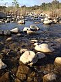
Ventura River flowing through cobble near Meiners Oaks.
|
|
| Country | United States |
| State | California |
| Physical characteristics | |
| Main source | Transverse Ranges Confluence of Matilija Creek and North Fork Matilija Creek, near Ojai 6,010 ft (1,830 m) 34°29′07″N 119°18′02″W / 34.48528°N 119.30056°W |
| River mouth | Pacific Ocean Ventura River Estuary, near Ventura 0 ft (0 m) 34°16′32″N 119°18′28″W / 34.27556°N 119.30778°W |
| Length | 16.2 mi (26.1 km) |
| Basin features | |
| Basin size | 226 sq mi (590 km2) |
| Tributaries |
|
The Ventura River is a river in Ventura County, southern California, United States. It flows for about 16.2 miles (26.1 km) from its start to the Pacific Ocean. It is the smallest of the three main rivers in Ventura County. The river flows through the narrow Ventura Valley. Its last 0.7 miles (1.1 km) goes through the wider Ventura River estuary, which is where it meets the ocean.
Contents
Understanding the Ventura River Area
What is a Watershed?
The Ventura River watershed is the entire area of land where water drains into the Ventura River. It covers 226 square miles (590 km2) of mountains and hills. The land here goes from 6,010 feet (1,830 m) high down to sea level.
Many parts of this watershed are natural and undeveloped. About 57% of the land is protected. Most streams flow freely, but two dams and three levees change how the water moves.
Only about 13% of the land is developed, not counting areas used for grazing animals. The northern part of the watershed is in Los Padres National Forest. The southern part has many farms, growing citrus fruits and avocados. Some land is also used for cattle.
Two cities and several smaller communities are in the watershed. The city of Ojai is completely within the watershed. It is about 13-mile inland (21 km) and 746 feet (227 m) high. Only a small part of the city of Ventura is in the watershed, right by the coast.
Not many people live in the watershed, and the population grows slowly. About 44,140 people live here, which is only 5.4% of Ventura County's population.
Where Does the River Flow?
The Ventura River flows for 16.2 miles (26.1 km) to the Pacific Ocean. Its main starting point is Matilija Creek, where it meets North Fork Matilija Creek. Matilija Creek brings the most water to the Ventura River.
Other creeks also join the river:
- San Antonio Creek joins from the east.
- Coyote Creek joins from the west, about 7 miles (11 km) from the ocean.
- Cañada Larga Creek joins from the east a bit further downstream.
Most of the Ventura River flows through a narrow valley with steep sides. The last part of the river, about 0.7 miles (1.1 km), widens into the Ventura River estuary before reaching the ocean.
Weather and Water Levels


The amount of rain changes a lot depending on the location, time of year, and from one year to the next. The lower part of the watershed gets about 14.12 inches or 359 millimetres of rain each year. The middle part gets about 19.20 inches or 488 millimetres, and the upper part gets about 28.74 inches or 730 millimetres.
Even in the wetter upper areas, rain does not fall very often. But when it does rain, it can be very heavy. It is common to get 20 inches or 510 millimetres of rain in just one week. This means the area often goes through times of drought (very little rain) and floods (too much rain). For example, in Ojai, 67% of years since 1906 have had less than the average rainfall.
Many parts of the Ventura River are dry for much of the year. Sometimes, surface water goes underground. In other places, underground water feeds the stream.
Plants and Animals (Ecology)
The Ventura River watershed has many different types of land and is mostly undeveloped. This, along with its Mediterranean climate, makes it a very special place for nature. It has many different natural homes for plants and animals, like:
- Grasslands
- Coastal sage scrub
- Chaparral (dense shrubs)
- Oak woodlands and savannas
- Forests with cone-bearing trees
- Riparian (riverbank) scrub, woodlands, and wetlands
- Wetlands where the river meets the ocean (estuary)
- Coastal areas with rocks and sand dunes
The Ventura River estuary, where the river meets the ocean, is a very important wetland. It is a valuable home for many different species.
This area is home to many protected plants and animals. There are 137 species protected by federal, state, or local laws. The southern California steelhead fish is especially important. These fish are an endangered species. Genetic tests show that the steelhead in the Ventura River are native to the area.
Water Quality Concerns
Because there is not much development and large areas are protected, the river water is fairly clean. However, all the main water bodies in the watershed have some problems. These problems include:
- Trash
- Too much algae
- Water being taken out or pumped away
- Low oxygen levels
- Too much nitrogen
- Things blocking fish from moving
- Bacteria and mercury
The estuary has had a problem with trash for over 10 years. In 2008, a plan was made to clean up the trash in the estuary. This plan aims to improve the water quality.
History of the River Area
An old oil refinery was located near the river. It was shut down in 1985. In 2012, the Environmental Protection Agency (EPA) found that the abandoned refinery was causing pollution. There were leaking pipes and tanks. The site also had a lot of trash. The EPA ordered the owner to clean up the site. In 2015, the owner agreed to remove all the old machinery and equipment.
Flooding Events
The Matilija Wilderness, where the river starts, gets the most rain in Ventura County. It gets more than twice the average rainfall of the coast. The steep land and heavy rains can cause flash floods. This means floodwaters rise and fall very quickly, sometimes in just a few hours. Major floods have happened about once every five years since 1933.
The worst flood in the Ventura River area happened in 1969. The area above Ojai received 43 inches (1,100 mm) of rain in nine days. The floodwaters and mud damaged homes and farms. Roads, bridges, and railroad tracks were also damaged. A wastewater treatment plant was badly damaged, causing pollution in the river.
Changes to the River
Water Supply for People
Unlike many places in southern California, the Ventura River watershed gets all its water from local sources. Lake Casitas is the main source of surface water. People also rely a lot on groundwater. About 55% of the water comes from the surface, and 45% comes from underground.
The amount of rain changes a lot each year. For example, downtown Ojai has had as little as seven inches of rain and as much as 49 inches in different years. Because rainfall varies so much, water supplies must be managed carefully.
Some nearby coastal areas also depend on water from the Ventura River watershed. This water is used to irrigate avocado farms and supply water to parts of the City of Ventura.
Dealing with Invasive Plants
The watershed faces a challenge from plants that are not native to the area. These include giant reeds, ice plants, and castor bean. These plants can grow very thick and push out native plants like willows. Native plants are important for local animals. Since the 1990s, there have been projects to bring back the natural plants and animals to the river.
Dams on the River

The flow of the Ventura River and Coyote Creek has been changed by the Casitas Dam. This dam creates Lake Casitas. The dam is on Coyote Creek, about 2 miles upstream from where it joins the Ventura River.
Another dam, the Robles Diversion Dam, was built on the Ventura River in 1958. It can send a lot of water through a canal to Lake Casitas. About 40% of the water in Lake Casitas comes from high flows in the Ventura River during winter. The Casitas Municipal Water District sells this water for homes and farms.
Matilija Creek, the main stream that feeds the Ventura River, is controlled by the Matilija Dam. It was built in 1948 to hold a lot of water. However, mud and dirt have filled it up, reducing its capacity by 90%. The dam was built even though experts warned that sediment would build up.
There is a big project planned to remove the Matilija Dam. One reason is to help the steelhead fish reach their spawning areas. Removing the dam would also improve the entire watershed. Efforts to remove the dam have been ongoing since 1998.
Protecting and Enjoying the River
River Protection Efforts
Different groups work to protect the river and the land next to it. These include the Ojai Valley Land Conservancy (OVLC), the Ventura Land Trust, and local government agencies. The Ventura River Preserve, owned by the OVLC, protects 1,600 acres (650 ha) of land along the river. This includes 3 miles (4.8 km) of the river itself.
The Ventura River Watershed Council, made up of many different groups, created a plan to improve the health of the watershed. This plan was approved in 2015.
Camping in the Ventura River bottom, which is usually dry, was made illegal in 1995. This happened after floods caused one death and forced 12 people to leave their homes near a bridge.
Recreation and Fun Activities

The Ventura River Parkway Trail was built on an old railroad line. This trail runs along the east side of the river. It was named a National Recreation Trail in 2014.
The "Ventura River Trail" part of it was finished in 1999. It goes from the coast to Foster Park. The "Ojai Valley Trail" part was finished in 1987. It goes from Foster Park into the city of Ojai. This 15.8-mile long (25.4 km) trail is popular for biking, walking, and horseback riding. There are plans to create a "Ventura River Parkway," which would be a network of trails and natural areas along the river.
State Route 33 also follows the river through the Ventura River Valley. Part of this road is a scenic highway.
The Ventura River watershed is a great place for many outdoor activities. People enjoy hiking, biking, surfing, camping, fishing, boating, and bird watching. Many local groups work to help people access and enjoy nature in this area.
Images for kids
-
Ventura River flowing through cobble near Meiners Oaks.
See also
 In Spanish: Río Ventura para niños
