Matilija Creek facts for kids
Quick facts for kids Matilija Creek |
|
|---|---|

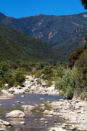
Matilija Creek in the Matilija Wilderness
|
|
| Other name(s) | Arroyo Matilija |
| Country | United States of America |
| State | California |
| Physical characteristics | |
| Main source | Santa Ynez Mountains, Santa Barbara County 5,200 ft (1,600 m) 34°35′45″N 119°27′31″W / 34.59583°N 119.45861°W |
| River mouth | Ventura River Ventura County 915 ft (279 m) 34°29′06″N 119°18′01″W / 34.48500°N 119.30028°W |
| Length | 18 mi (29 km) |
| Basin features | |
| Basin size | 54.6 sq mi (141 km2) |
| Tributaries |
|
Matilija Creek (mə-TIL-i-hah) is an important creek in Ventura County, California. It joins with North Fork Matilija Creek to form the Ventura River. Many smaller streams, called tributaries, flow into Matilija Creek. The creek is about 17.3-mile (27.8 km) long and mostly flows freely. Much of it is located within the Matilija Wilderness, a protected natural area.
Long ago, the area around Matilija was home to the Chumash people. It was one of their villages, or rancherias, connected to Mission San Buenaventura. We don't know what the Chumash name "Matilija" means.
Contents
Where Matilija Creek Flows
Matilija Creek starts in the Santa Ynez Mountains in Santa Barbara County. This area is south of Sespe Creek and inside the Matilija Wilderness. From there, the creek flows east and then south through a narrow, V-shaped valley. It then enters Ventura County.
Below Matilija Falls, the creek turns east. Here, the Upper North Fork joins it from the left. Almost immediately after, the West Fork (also known as Murietta Canyon) flows in from the right. The creek then continues east through a wider valley. This valley runs along the north side of the Santa Ynez Mountains.
Meeting the Ventura River
Eventually, Matilija Creek flows into the Matilija Lake reservoir. This reservoir was created by the 200-foot (61 m) tall Matilija Dam. The reservoir is now mostly filled with mud and sand. Below the dam, the creek flows southeast. It passes through Matilija Hot Springs. Finally, it meets the North Fork Matilija Creek at a small community called Ojala. This is where the two creeks combine to form the Ventura River.
The North Fork Matilija Creek
The smaller North Fork Matilija Creek starts near Rose Valley. It flows west and then south. This fork runs southwest along Forest Route 6N31. Along its path, Cannon Creek joins it from the right, and Bear Creek joins from the left. The North Fork then flows through the narrow Wheeler Gorge and the town of Wheeler Springs. It briefly flows east before joining Matilija Creek a short distance downstream. Highway 33 runs mostly next to the North Fork, from Dry Lakes Ridge to where it meets Matilija Creek.
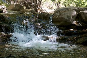
Even though the area is dry, Matilija Creek flows all year round. This is because it is fed by some natural springs that always have water. However, after heavy winter storms, the creek can flood very badly.
Plants and Animals of Matilija Creek

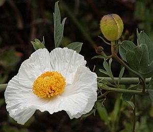
The beautiful Matilija poppy (Romneya) gets its name from the Matilija Creek canyon. This flower is native to the area.
Matilija Creek is also home to fish. In the past, many Steelhead trout (Oncorhynchus mykiss) lived here. These fish are special because they are anadromous. This means they are born in fresh water, live in the ocean, and then return to fresh water to lay their eggs. Historically, about 5,000 steelhead trout used the upper Matilija basin for spawning (laying eggs).
Challenges for Steelhead Trout
The Matilija Dam was built in 1947 on the lower part of Matilija Creek. Its purpose was to store water and help control floods. However, the dam blocked the steelhead trout from reaching over ten miles of their spawning areas upstream.
Another dam, the Robles Diversion Dam on the Ventura River downstream, also blocked the trout. But in 2006, a special $6 million fish ladder was built there. This ladder helps the trout swim past the dam. Recent studies of the steelhead trout in Matilija Creek show that they are native fish, not fish from hatcheries.
Changes to the Creek
The Matilija Dam is the only dam on Matilija Creek. It was built in 1947. The dam was meant to help control floods and provide water for farms and cities in Ventura County. When it was first finished, the dam was 190 feet (58 m) high. It could hold more than 7,000 acre-feet (0.0086 km3) of water.
However, over time, the reservoir behind the dam has almost completely filled up with sediment. Sediment is like mud, sand, and small rocks carried by the water. Because of this, the reservoir can no longer hold much water.
To help with the sediment problem, parts of the dam were removed twice in the late 1900s. This allowed some of the built-up sediment to flow downstream. Currently, there are plans to remove the entire dam. This would help the creek flow more naturally and allow fish to move freely again.
 | William L. Dawson |
 | W. E. B. Du Bois |
 | Harry Belafonte |


