
Santa Ynez Mountains facts for kids
Quick facts for kids Santa Ynez Mountains |
|
|---|---|

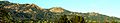
Upper San Roque Canyon in the Santa Ynez Mountains, Santa Barbara County
|
|
| Highest point | |
| Peak | Peak 4864 |
| Elevation | 4,864 ft (1,483 m) |
| Geography | |
| Country | United States |
| State | California |
| District | Santa Barbara County Ventura County |
| Range coordinates | 34°30′03″N 119°43′47″W / 34.5009°N 119.72969°W |
The Santa Ynez Mountains are a mountain range found along the west coast of North America in California. They are part of the larger Transverse Ranges and are the westernmost mountains in this group.
These mountains were formed by the movement of a large fault block called the Santa Ynez Fault. This happened during the Cenozoic Era, which began about 66 million years ago. The Santa Ynez Mountains are very narrow. They rise steeply on their north side and drop just as sharply on their south side.
The range starts as small volcanic hills near Point Arguello. As you go east, it becomes a single, clear ridge. This ridge stretches from Gaviota Peak to Matilija Creek. Further east, the Santa Ynez Mountains connect with the Topatopa Mountains.
The climate here is Mediterranean, meaning it has warm, dry summers and mild, wet winters. Most of the rain falls between November and March. The mountains are mostly covered by California chaparral and woodlands, which is a type of shrubland. Higher up and on the cooler north slopes, you can find many oak trees and other broadleaf trees like madrone and sycamore. Some pine trees, especially Coulter pines, also grow here.
Contents
Where Are the Santa Ynez Mountains Located?
These mountains are mainly in Santa Barbara County. They also extend a bit eastward into Ventura County. What makes them special is that they are one of the few mountain ranges in the United States that run completely from east to west. Scientists think this is because large pieces of the Earth's crust rotated clockwise about 17 million years ago. Most of the range is located within the Los Padres National Forest.
What Forms the Mountain Boundaries?
The northern edge of the Santa Ynez Mountains is defined by the Santa Ynez Fault. This is a huge thrust fault that has been pushing the mountains up for about 5 million years, starting in the Pliocene epoch. Important places along this fault include Jalama Creek and the Santa Ynez River to the west, and Matilija Creek in the far east. To the north of these mountains are the San Rafael Mountains. The southern slopes of the Santa Ynez Mountains gently lead down to flat plains next to the Santa Barbara Channel.
How Far Do the Mountains Stretch?
The mountains start in the east near the Ventura River canyon and Matilija Creek, north of Ojai. They stretch west across the Santa Barbara County line, passing just north of Santa Barbara. They continue west, running parallel to the coast, all the way to Lompoc and Vandenberg Air Force Base. The Santa Ynez River flows just north of the mountains for most of their length. Before reaching Lompoc, the range splits into two lower ridges, separated by Jalama Creek, and then disappears into the Pacific Ocean.
The Santa Ynez Mountains run parallel to the Channel Islands to the south. The Channel Islands are another east-west mountain range, about 30 miles away.
What Are the Highest Peaks and Passes?
Some of the main peaks in the Santa Ynez range include Divide Peak, 4,707 ft (1,435 m), La Cumbre Peak, 3,985 ft (1,215 m) (which is above Santa Barbara), and Santa Ynez Peak, 4,298 ft (1,310 m).
There are also several important passes. Gaviota Pass is in the western part of the range, where U.S. Highway 101 goes through the Gaviota Tunnel. Near Santa Barbara is San Marcos Pass, where California State Route 154 crosses. This route includes the amazing Cold Spring Canyon Arch Bridge near the summit.
The very highest point is an unnamed peak, often called Peak 4864. It is located right above the eastern end of the range, close to Lake Casitas and Matilija Canyon.


How Were the Santa Ynez Mountains Formed?
Geologically, these mountains are quite young. They are mostly made of sedimentary rocks, which are formed from layers of sediment that have hardened over time. The most common rocks here are sandstones and shales. You can also find some limestone in the western part of the range.
Volcanic rocks are present at the very western end, near Point Arguello. Some schist rocks, part of the Franciscan Assemblage, can be seen in a few spots.
The Santa Ynez Mountains were lifted up during the Pliocene and Pleistocene epochs, starting about 5 million years ago. This uplift happened along the Santa Ynez Fault, which is still active today. Scientists believe that a bend in the San Andreas Fault helped push the land northward, causing these mountains to rise. Because they are a young mountain range, their slopes are very steep and the land is rugged. The steepest parts are on the northern side, above 1,500 feet (460 m), right next to the fault line. You can see dramatic sandstone formations, like the strong Coldwater Sandstone and Matilija Sandstone formations, in many places.
What Kinds of Plants and Animals Live Here?
The main type of plant cover is chaparral, which is a dense scrubland. At lower elevations, you'll find coastal sage scrub, oak woodlands, and grasslands.
On the higher parts of the northern slopes, which are cooler and shadier, there are isolated groups of conifer trees, mostly Coulter pines. Other evergreen trees like bay laurel, tanbark oak, and madrone also grow here. The southern side of the range, at lower elevations, is almost always free of frost. This makes it a great place to grow avocados in large amounts.

Who Has Lived in the Santa Ynez Mountains?
The earliest people to live in these mountains were the Chumash people. They left behind many examples of rock art, including those at Painted Cave SHP.
Today, large parts of the mountain range are part of the Los Padres National Forest. However, there are also private lands and communities within the forest. One such community is Painted Cave. Famous people have lived in these mountains, including Ronald Reagan, whose Rancho del Cielo was at the top of the range west of Santa Barbara. The Cold Spring Tavern is a popular local spot located beneath the Cold Spring Bridge.

What is the Climate Like?
The climate in the Santa Ynez Mountains is Mediterranean. Summers are warm and usually have no rain, except for a few monsoonal showers in August and September. However, most years see no rain between May and October.
The higher coastal slopes of the range typically get between 30 inches (760 mm) to almost 40 inches (1,000 mm) of rain each year. This is about twice as much as the coastal plain below. Most of this rain falls between November and March. About once every three years, snow falls on the higher peaks, but it usually melts within a few days.
In late spring and early summer, the mountains and areas to the south sometimes experience strong sundowner winds. These are a type of foehn wind that gets hotter and drier as it moves down the slopes. In dry years, these winds can cause a very high risk of wildfires.
Wildfires in the Mountains
Sometimes, very destructive fires start in the Santa Ynez Mountains. In June 1990, a fire began near Painted Cave and was pushed south into Santa Barbara by sundowner winds. It destroyed over 500 homes. A fire in the 1940s destroyed most of the mansion now known as Knapp's Castle. More recent fires, like the Tea and Jesusita fires, have also caused a lot of damage to properties.
Images for kids
-
Santa Ynez Mountain peaks looking NNE from Santa Barbara.
