Santa Ynez River facts for kids
Quick facts for kids Santa Ynez River |
|
|---|---|
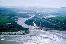
Aerial view of the mouth of the river
|
|
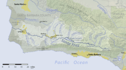
Map of the Santa Ynez River watershed
|
|
| Other name(s) | Río Grande de San Vernardo |
| Country | United States |
| State | California |
| County | Santa Barbara |
| Cities | Solvang, Lompoc |
| Physical characteristics | |
| Main source | Transverse Ranges 4,140 ft (1,260 m) 34°28′40″N 119°26′51″W / 34.47778°N 119.44750°W |
| River mouth | Pacific Ocean 0 ft (0 m) 34°41′31″N 120°36′7″W / 34.69194°N 120.60194°W |
| Length | 92 mi (148 km) |
| Basin features | |
| Basin size | 896 sq mi (2,320 km2) |
| Tributaries |
|
The Santa Ynez River is one of the biggest rivers on the Central Coast of California. It is about 92 miles (148 km) long. The river flows from east to west through the Santa Ynez Valley. It finally reaches the Pacific Ocean near Surf, which is close to Vandenberg Air Force Base and the city of Lompoc.
This river collects water from a large area. It drains the northern side of the Santa Ynez Mountains and the southern side of the San Rafael Mountains. It also covers a big part of southern Santa Barbara County. The river's drainage basin is about 896 square miles (2,320 km2) in size. The amount of water in the river changes a lot. In summer, it often dries up almost completely. But in winter, it can become a very strong, fast-flowing river. There are three dams on the river. These dams can hold a total of 210,000 acre-feet (260,000,000 m3) of water during wet years.
Contents
River History
The Santa Ynez River was first named by Spanish explorers. The Portolá expedition was the first European group to explore Alta California by land. They camped near the river's mouth on August 30, 1769. The explorers couldn't agree on one name for the river. So, their journals recorded three different names. Engineer Miguel Costanso wrote "Río Grande de San Verardo." Another explorer, Juan Crespi, wrote "San Bernardo" and "Santa Rosa." None of these first names are used for any features in the area today.
Instead, the river and nearby mountains got their name from Mission Santa Inés. This mission was built in 1804. It was named after Saint Agnes of Rome. The USGS lists other old names for the Santa Ynez River. These include La Purisima River, Rio De La Purisima, and Rio De Santa Ines.
River Journey: From Source to Ocean
The Santa Ynez River starts in the Los Padres National Forest. Its source is on the northern side of the Santa Ynez Mountains. This is near Divide Peak and the border of Ventura County. The river flows west, gathering water from many smaller streams. The Upper Santa Ynez Campground is close to where the river begins.
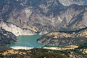
After flowing through Billiard Flats, the river enters Jameson Lake. This lake is a reservoir created by Juncal Dam. Below this dam, Alder Creek joins the Santa Ynez River from the south. Sometimes, water from Alder Creek is sent into Jameson Lake through a tunnel.
The Santa Ynez River continues flowing west. It passes by several campgrounds and canyons, like Blue Canyon. Mono Creek joins from the north. Soon after, the Santa Ynez flows into Gibraltar Reservoir, which is held back by Gibraltar Dam. Below this dam, the river passes more campgrounds and places like the Los Prietos Ranger Station. Paradise Road runs along the river here. Further west, the river goes by Fremont Campground near Red Rock Canyon.
West of Red Rock Canyon, the river leaves Los Padres National Forest. Its valley becomes much wider. Kelly Creek joins from the south, bringing water from Los Laureles Canyon and Cold Spring Canyon. State Route 154 then enters the Santa Ynez River valley. It follows the river west for several miles. Hot Spring Canyon joins from the south just before the Santa Ynez River flows into Lake Cachuma.
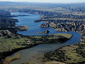
Lake Cachuma is the biggest reservoir on the river. It is about five miles long. Many smaller streams join the Santa Ynez River in Lake Cachuma. These include Santa Cruz Creek and Cachuma Creek from the north. The area around the lake is called the Lake Cachuma Recreation Area. Cachuma County Park offers access to the lake. Water from Lake Cachuma is sent through the Tecolote Tunnel. This tunnel goes south under the mountains to the Santa Barbara area.
Below Lake Cachuma, the Santa Ynez River keeps flowing west. Its valley continues to widen. You can see ranches and other buildings along its banks. The river passes by the town of Santa Ynez and the cities of Solvang and Buellton. In Buellton, U.S. Route 101 crosses the river. Several streams join the river in this area. These include Quiota Creek, Alisal Creek, and Nojoqui Creek from the south. From the north, Santa Agueda Creek, Zanja de Cota Creek, Alamo Pintado Creek, and Zaca Creek join.
West of Buellton, the Santa Ynez River flows between the Santa Rita Hills and Purisima Hills to the north. To the south are the Santa Rosa Hills. Santa Rosa Creek joins from the north. Salsipuedes Creek joins from the south. Just west of Salsipuedes Creek, the Santa Ynez River flows past Lompoc. This is the largest city in the valley. A few miles west of Lompoc, the river reaches the Pacific Ocean at a place called Surf. There is a beach and an Amtrak train station here. People can visit Surf and the river's mouth. However, most of the land between Lompoc and the ocean is part of Vandenberg Air Force Base.
River Flow: How Much Water?
The USGS measures the river's flow at several points. One measuring station is at Narrows, near Lompoc. The average amount of water flowing past this point since 1952 is 127 cubic feet per second (3.6 m3/s). This is after Lake Cachuma started controlling the flow. The most water ever recorded at this station was 80,000 cubic feet per second (2,300 m3/s) on January 25, 1969. Before the measuring station was built, an even bigger flood happened. On January 9, 1907, an estimated 120,000 cubic feet per second (3,400 m3/s) of water flowed. For several months each year, the river has no flow at all.
River Changes: Dams and Their Effects
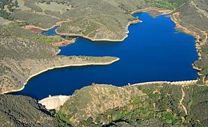
There are three large reservoirs on the Santa Ynez River. The biggest is Lake Cachuma. It can hold 205,000 acre-feet (253,000,000 m3) of water. Bradbury Dam created this lake. It was built by the U.S. Bureau of Reclamation. Water from Lake Cachuma is sent through the Tecolote Tunnel. This tunnel goes south under the Santa Ynez Mountains. The water supplies drinking water to cities like Santa Barbara, Goleta, Carpinteria, and Montecito. Water is also released from Lake Cachuma into the river below Bradbury Dam. This is to make sure people downstream still get their water rights.
The other two reservoirs are Gibraltar Reservoir and Jameson Lake. Gibraltar Reservoir is formed by Gibraltar Dam. It provides water to the City of Santa Barbara through another tunnel. Jameson Lake is formed by Juncal Dam. It supplies water to the Montecito Water District, also through a tunnel. In 2004, these dams diverted thousands of acre-feet of water.
A report from 2010 looked at how to restore the Santa Ynez River estuary. The estuary is where the river meets the ocean. The report found that human activities, especially building dams, have greatly changed the river's flow. Dams now control 47% of the water that flows into the river each year. This has reduced how often the river's mouth opens to the ocean. It has also reduced the size and frequency of floods. Floods are important for keeping the river's wetlands healthy. The changes have caused some wetland habitats to turn into dry land.
River Life: Animals and Their Homes
In the 1940s, the Santa Ynez River was known for having many steelhead fish. Steelhead are a type of rainbow trout that live in the ocean and return to rivers to lay eggs. Before Cachuma Dam was built in 1953, about 25,000 adult steelhead would return to the river. Even earlier, in 1920, Gibraltar Dam was built. This dam blocked access to important spawning areas further up the river. So, the number of steelhead was likely much higher before then.
The Southern California steelhead population is now endangered. This means their numbers have dropped by 99% in the last century. There are still wild rainbow trout living above Cachuma Dam. Some of these young trout might go to the ocean and become steelhead. However, many don't survive the trip because of low water levels or predators near the coast. Scientists have studied the steelhead in the Santa Ynez River. They found that these fish are native to the area, not from fish farms.
The lower Santa Ynez River and Salsipuedes Creek are home to California Golden beavers. There are about a dozen beaver dams in this area. Even with these dams, steelhead can usually get around, over, or through them. Steelhead are often found in rivers where beavers live. Also, strong winter flows can break up beaver dams, allowing fish to pass. Beavers are very important for steelhead. Their ponds help refill underground water sources. This allows streams to keep flowing in dry summers. These ponds also provide safe places for young trout to stay during the summer. In fact, more fish and bigger fish are found when beavers are present.
There is evidence that beavers lived in southern California coastal streams a long time ago. A beaver skull was found in Ventura County in 1906. There is also a Chumash pictograph (rock painting) of a beaver nearby. The Chumash people, who are native to this area, even had a Beaver Dance. Their word for beaver is Chipik. All these facts suggest that beavers once lived throughout Santa Barbara County, California. However, beavers in the Santa Ynez River were likely trapped until they were brought back in the 1940s.
The endangered Tidewater goby is also found in the river's salty coastal lagoon. It lives several miles upstream in parts of the river where beavers have built dams. These beaver-made areas create slow-moving water, which is perfect habitat for gobies.
See also
 In Spanish: Río Santa Ynez para niños
 | Calvin Brent |
 | Walter T. Bailey |
 | Martha Cassell Thompson |
 | Alberta Jeannette Cassell |


