Santa Ynez, California facts for kids
Quick facts for kids
Santa Ynez
|
|
|---|---|

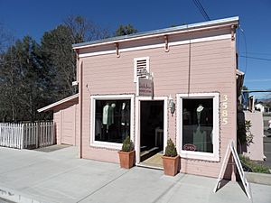
A boutique with western-style architectural details
|
|

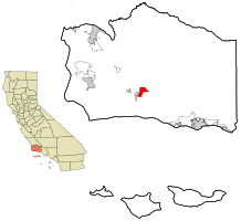
Location in Santa Barbara County and the state of California
|
|
| Country | |
| State | |
| County | Santa Barbara |
| Area | |
| • Total | 5.143 sq mi (13.321 km2) |
| • Land | 5.136 sq mi (13.302 km2) |
| • Water | 0.007 sq mi (0.019 km2) 0.14% |
| Elevation | 607 ft (185 m) |
| Population
(2020)
|
|
| • Total | 4,505 |
| • Density | 875.95/sq mi (338.19/km2) |
| Time zone | UTC-8 (PST) |
| • Summer (DST) | UTC-7 (PDT) |
| ZIP code |
93460
|
| Area code(s) | 805 |
| FIPS code | 06-70182 |
| GNIS feature ID | 1661407 |
Santa Ynez is a small community in Santa Barbara County, California. Its name comes from the Spanish for "St. Agnes." It is part of the beautiful Santa Ynez Valley.
This town is one of several communities in the Santa Ynez Valley. It has its own airport, the Santa Ynez Airport, which is used for smaller planes. The airport has a paved runway that is about 2,804 feet long. In 2020, about 4,505 people lived in Santa Ynez. The name "Santa Ynez" is an older way of spelling Santa Inés in Spanish.
Contents
Exploring Santa Ynez Geography
Santa Ynez is located at coordinates 34°36′43″N 120°5′18″W.
The community covers an area of about 5.1 square miles. Most of this area is land, with a very small part being water. Santa Ynez is located about 40 miles north of Santa Barbara, California. It is well-known for its many wineries, which produce world-class wines.
Santa Ynez Climate and Weather
Santa Ynez has a type of weather called a warm-summer Mediterranean climate. This means it has warm, dry summers. The average monthly temperature in summer does not go above 71.6 degrees Fahrenheit (22 degrees Celsius). Winters are mild and wet.
Who Lives in Santa Ynez?
| Historical population | |||
|---|---|---|---|
| Census | Pop. | %± | |
| 2000 | 4,584 | — | |
| 2010 | 4,418 | −3.6% | |
| 2020 | 4,505 | 2.0% | |
| U.S. Decennial Census | |||
Population in 2010
In 2010, Santa Ynez had a population of 4,418 people. Most residents, about 85.9%, were White. Other groups included Native American (5.3%), Asian (1.2%), and African American (0.3%). About 14.5% of the population identified as Hispanic or Latino.
There were 1,741 households in Santa Ynez. About 30.1% of these households had children under 18 living there. The average household had 2.54 people. The average family size was 2.91 people.
The median age of people in Santa Ynez was 47.8 years old. This means half the people were younger than 47.8 and half were older. About 20.7% of the population was under 18 years old. About 19.9% of the population was 65 years or older.
Most homes, about 76.2%, were owned by the people living in them. The remaining 23.8% were rented.
Population in 2000
In 2000, the population of Santa Ynez was 4,584 people. The racial makeup was similar to 2010, with about 91.84% White residents. Hispanic or Latino people made up about 9.21% of the population.
The median age in 2000 was 42 years. About 26.2% of the population was under 18 years old.
The Santa Ynez Band of Chumash Mission Indians, a federally recognized Chumash tribe, has its main office in Santa Ynez. They also run the Chumash Casino Resort in the area.
Famous People from Santa Ynez
Many well-known people have lived in Santa Ynez, including:
- Bob Falkenburg, a professional tennis player
- Ed Fitz Gerald, a professional baseball player
- Eion Bailey, an actor
- Tyler Boyd, a professional soccer player
- John Corbett, an actor
- Bo Derek, an actress
- Rona Barrett, an actress
- Olivia Newton-John, a singer and actress
- Michael Jackson, a singer
- P!nk, a singer and actress
- David Crosby, a singer
See also
 In Spanish: Santa Ynez para niños
 | William Lucy |
 | Charles Hayes |
 | Cleveland Robinson |


