
San Rafael Mountains facts for kids
Quick facts for kids San Rafael Mountains |
|
|---|---|

San Rafael Mountains from near La Cumbre Peak with McKinley Mountain and San Rafael Mountain visible in the distance
|
|
| Highest point | |
| Peak | Big Pine Mountain |
| Elevation | 6,820 ft (2,080 m) |
| Geography | |

Location in California
|
|
| Country | United States |
| State | California |
| District | Santa Barbara County |
| Range coordinates | 34°42′38.951″N 119°48′51.495″W / 34.71081972°N 119.81430417°W |
| Parent range | Transverse Ranges system |
| Topo map | USGS San Rafael Mountain |
| Biome | California chaparral and woodlands |

The San Rafael Mountains are a mountain range located in the middle of Santa Barbara County, California, in the U.S.. These mountains act like a natural wall, separating the areas where the Santa Ynez River and the Santa Maria River collect their water. They are part of a larger group of mountains called the Transverse Ranges system in Southern California. This system is also part of the Pacific Coast Ranges that stretch along western North America.
Contents
Exploring the San Rafael Mountains
Most of the San Rafael Mountains are located inside the Los Padres National Forest. The northern parts of these mountains are even more protected, forming a wild area known as the San Rafael Wilderness. This means these areas are kept as natural as possible, with limited human impact.
Tallest Peaks and Unique Spots
The highest points in the San Rafael Mountains are quite impressive. Big Pine Mountain is the tallest, reaching 6,820 feet (2,079 meters). Other high peaks include San Rafael Mountain (6,593 feet or 2,010 meters) and McKinley Mountain (6,220 feet or 1,896 meters). These peaks are not easy to reach; you usually need to hike or ride a horse to get there. Little Pine Mountain is the highest peak on the southern edge of the range.
Deep within the San Rafael Wilderness, you can find a unique rock formation called Hurricane Deck. It's a huge block of sandstone that looks amazing.
Rivers and Waterfalls
The Sisquoc River starts its journey on the northern slopes of Big Pine Mountain. This river is special because it's a designated Wild and Scenic River of the United States. This means it's protected for its natural beauty and importance. The Sisquoc River eventually flows into the Santa Maria River. You can also find Sisquoc Falls, a 250-foot (76-meter) high waterfall, on a smaller stream that feeds into the Sisquoc River, west of Big Pine Mountain.
Mountain Weather
The San Rafael Mountains have a moderate climate. Summers are hot and dry, with thunderstorms happening very rarely. Winters are cool to cold and wet. Sometimes, snow falls on the higher parts of the mountains between December and March when cold fronts pass through. The mountains usually get between 15 and 25 inches of rain each year.
Highest Points in the Mountains
Here are the six highest peaks in the San Rafael Mountains. These peaks stand out because they rise at least 500 feet above the land around them:
- Big Pine Mountain, 6,820 feet (2,079 meters)
- San Rafael Mountain, 6,593 feet (2,010 meters)
- Madulce Peak, 6,539 feet (1,993 meters)
- Monte Arido, 6,013 feet (1,833 meters)
- Ortega Peak, 5,857 feet (1,785 meters)
- Figueroa Mountain, 4,534 feet (1,382 meters)
How the Mountains Were Formed
The San Rafael Mountains are mostly made up of sedimentary and metamorphic rocks. These rocks were formed from layers of sediment or changed by heat and pressure. Most of them are from the Jurassic period or more recent times. There are also a few areas where igneous rocks, formed from cooled lava or magma, have pushed through.
Several large cracks in the Earth's crust, called faults, run through the mountains. One important one is the Big Pine Fault. It stretches eastward and connects to the famous San Andreas Fault about forty miles away.
Plants and Animals of the Mountains
The San Rafael Mountains are very steep and rugged. The lower slopes are covered mostly by chaparral, a type of shrubland. This ecosystem is naturally designed to handle large, intense fires every 30 to 100 years or more. Over the last century, almost every part of the San Rafael Mountains has experienced a fire. This is largely due to more fires being started by people.
In the shadier, wetter canyons and on the northern slopes, you can find oak woodlands. There are also bigcone Douglas-fir trees and Coulter pine trees. Gray pine trees are also scattered among the chaparral-covered slopes.
Above the chaparral zone, there are forests of conifer trees. These forests are part of the California mixed evergreen forest ecosystem. They include trees like Jeffrey pine, ponderosa pine, Coulter pine, sugar pine, singleleaf pinyon pine, white fir, and incense cedar. Snow is common in winter at elevations above about 6,000 feet (1,800 meters). Even with the snow, the overall climate of the mountains is Mediterranean, meaning it has mild, rainy winters and warm, dry summers.
A Look at Human History
The very first people known to live in the San Rafael Mountains were the Chumash Indians. If you are an adventurous hiker, you might still find signs of their presence. These signs include pictograph rock paintings hidden in remote areas.
More recently, in historical times, people mined for mercury on some of the southern slopes. The leftover materials from these old mines sometimes have high levels of mercury. Environmental studies have been done to see if these areas need to be cleaned up to protect the environment.
The central part of the mountains is part of the Santa Ynez Recreation area. This area is within the Los Padres National Forest and is a popular spot for hiking. It has many campgrounds where people can stay and enjoy nature.
Images for kids
-
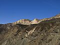
The San Rafael Mountains between Alexander Peak and Little Pine Mountain.

