
Big Pine Mountain facts for kids
Quick facts for kids Big Pine Mountain |
|
|---|---|
| Highest point | |
| Elevation | 6803+ ft (2074+ m) NAVD 88 |
| Prominence | 2,160 ft (658 m) |
| Listing | California county high points 33rd Hundred Peaks Section |
| Geography | |
| Location | Santa Barbara County, California, U.S. |
| Parent range | San Rafael Mountains |
| Topo map | USGS Big Pine Mountain |
| Climbing | |
| Easiest route | Dirt Road |
Big Pine Mountain is an impressive mountain located in the San Rafael Mountains in California. It's so tall that it often gets snow during the winter months, making it a truly special place. The very top of the mountain, called the summit, reaches over 6,820 feet (2,073 meters) high! This makes it the highest point in the entire San Rafael Mountains range. It's also the tallest spot in the Dick Smith Wilderness and all of Santa Barbara County.
Contents
Discover Big Pine Mountain
Big Pine Mountain is a significant landmark in Southern California. It stands proudly as part of the Transverse Ranges, which are a series of mountain ranges that run east to west. This is unusual because most mountain ranges in North America run north to south.
Where is Big Pine Mountain?
This amazing mountain is located in Santa Barbara County, within the Los Padres National Forest. It's part of the beautiful San Rafael Mountains. This area is known for its rugged landscapes and diverse wildlife.
How Tall is Big Pine Mountain?
Standing at over 6,820 feet (2,073 meters), Big Pine Mountain is quite a giant! Its height means it often gets covered in snow during the colder parts of the year. This makes it a unique sight in sunny California. Being the highest point in Santa Barbara County, it offers incredible views from its summit.
Exploring the Area
The area around Big Pine Mountain is part of the Dick Smith Wilderness. A wilderness area is a protected natural space where human activity is limited to preserve its wild character. This means you can experience nature in a very untouched way. The easiest way to reach the summit is by using a dirt road, which makes it accessible for hikers and explorers.
Images for kids
-
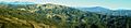
An aerial view showing the Big Pine, Reyes, and Pinos peaks area.
