Madulce Peak facts for kids
Quick facts for kids Madulce Peak |
|
|---|---|

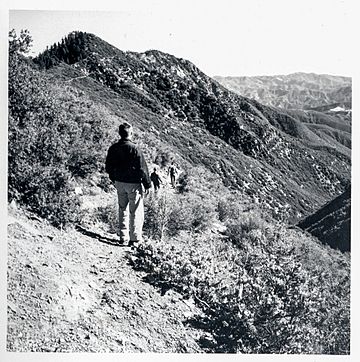
Hikers en route to Madulce Peak in 1963. Madulce Peak is the highest point on the left.
|
|
| Highest point | |
| Elevation | 6,539 ft (1,993 m) NAVD 88 |
| Prominence | 896 ft (273 m) |
| Listing | Hundred Peaks Section |
| Geography | |
| Location | Santa Barbara County, California, U.S. |
| Parent range | San Rafael Mountains |
| Topo map | USGS Madulce Peak |
| Climbing | |
| Easiest route | Hike, Madulce Peak Trail |
Madulce Peak is a tall mountain located in Santa Barbara County, California. It is part of the San Rafael Mountains, which are a range within the larger Transverse Ranges. This peak is special because it's the highest point in the Dick Smith Wilderness, a protected natural area. Years ago, a fire lookout tower stood on its summit. It was built in the 1930s but sadly burned down in the 1970s.
What's in a Name? The Story of Madulce Peak
From Strawberry Peak to Madulce
The mountain wasn't always known as Madulce Peak. When surveyors first mapped the area, they called it Strawberry Peak. Over time, the name "Madulce" slowly became more common.
How "Madulce" Got Its Name
The United States Board on Geographic Names first thought "madulce" was the Spanish word for "strawberry." However, experts from the United States Forest Service did some research. They found out that "madulce" is actually a local slang word. Farmhands in the area used this word for "strawberry." It comes from the Catalan word "maduixa," which also means strawberry. So, the mountain's name still connects to strawberries, just in a unique way!
 | Isaac Myers |
 | D. Hamilton Jackson |
 | A. Philip Randolph |

