Alta California facts for kids
Quick facts for kids Alta California |
|||||||||
|---|---|---|---|---|---|---|---|---|---|
| Province of the Viceroyalty of New Spain (1804–1821) Province of the First Mexican Empire (1821–1824) Federal Territory of Mexico (1824–1836) |
|||||||||
| 1804–1836 | |||||||||
 |
|||||||||
| Capital | Monterey (1804–1836) | ||||||||
| Demonym | Californio | ||||||||
| Government | |||||||||
| Governor | |||||||||
|
• 1804–1814
|
José Joaquín de Arrillaga (First Spanish governor) |
||||||||
|
• 1815–1822
|
Pablo Vicente de Solá (Last Spanish governor) |
||||||||
|
• 1822–1825
|
Luis Antonio Argüello (First Mexican governor) |
||||||||
|
• 1836
|
Nicolás Gutiérrez (Last Alta California governor) |
||||||||
| Historical era | Spanish colonial era | ||||||||
| 1769 | |||||||||
|
• Established
|
1804 | ||||||||
| August 24, 1821 | |||||||||
| January 13, 1847 | |||||||||
|
• Disestablished
|
1836 | ||||||||
|
|||||||||
| Today part of | United States
Mexico |
||||||||
| Top - 0-9 A B C D E F G H I J K L M N O P Q R S T U V W X Y Z |
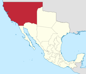
Alta California (meaning 'Upper California') was a large area of land in North America. It was first a province of New Spain (which was ruled by Spain). Later, it became a territory of Mexico.
Alta California was officially created in 1804. Before that, it was part of a larger area called Las Californias (The Californias). This larger area also included the Baja California peninsula.
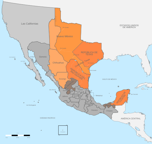
The land claimed by Alta California was huge! It included all of today's U.S. states of California, Nevada, and Utah. It also covered parts of Arizona, Wyoming, Colorado, and New Mexico.
However, Spain and later Mexico never really controlled all of this land. They mostly settled the southern and central coastal areas of present-day California. Many inland areas, like the Central Valley, remained home to Native American tribes.
Alta California stopped being a separate area in 1836. It was combined with Baja California again. But this change didn't last long. In 1846, the United States military took over California during the Mexican–American War. Most of Alta California became part of the United States in 1848 after the war ended. Two years later, California became the 31st U.S. state. Other parts of Alta California became states like Nevada, Utah, Arizona, Colorado, and Wyoming.
Spanish Exploration and Settlement
Early Missions and Forts
Between 1683 and 1834, Jesuit and Franciscan missionaries built many religious outposts. These were called missions. They stretched from today's Baja California up into present-day California.
One important missionary was Father Eusebio Kino. He worked in the southern Arizona area from 1687 to 1711. Spain wanted to expand its control north. They were worried about other countries, like Russia and England, trying to settle in North America.
The first mission and fort (called a presidio) in Alta California were built in San Diego in 1769. This was done by the Franciscan friar Junípero Serra and explorer Gaspar de Portolá. The next year, in 1770, they founded a second mission and presidio in Monterey.
Life Under Spanish Rule
Spanish law said that mission lands and property should eventually go to the Native American people. This was supposed to happen after about ten years. The Franciscans were meant to manage the land for the Native residents. However, the Franciscans kept control of the missions for much longer. They continued to run them even after Mexico became independent. The land was never fully given to the Native people by the Franciscans.
As more Spanish settlers arrived, there were disagreements over land. Conflicts arose between the Spanish government, the Church, and Native peoples. For example, priests at Mission Santa Clara de Asís wrote to the governor in 1782. They said that the Mission Indians owned their land and cattle. They argued that settlers' livestock was damaging Native crops and mixing with Native cattle.
In 1804, because more Spanish people were settling in the north, Las Californias was divided. The area south of San Diego became Baja California, and the area north became Alta California. Governor Diego de Borica helped set these official borders.
In 1819, the Adams–Onís Treaty was signed between the United States and Spain. This treaty set the northern border of Alta California at 42°N latitude. This line is still the border today between California, Nevada, and Utah (to the south) and Oregon and Idaho (to the north).
Ranchos and Californio Culture
The Spanish and later Mexican governments gave large land grants to retired soldiers. These grants were called ranchos. They were used for raising cattle and sheep. Hides and fat (tallow) from these animals were the main products California sold to other places.
Native Americans did most of the work on these large ranches. They learned to speak Spanish and ride horses. Sadly, many Native Californians died from European diseases.
Under Spanish and Mexican rule, the ranchos grew and became very successful. The rancheros (cattle ranchers) and pobladores (townspeople) developed a unique culture. They were known as Californios.
Independent Mexico
Mexico gained its independence from Spain on August 24, 1821. This happened after a ten-year war called the Mexican War of Independence. Because Mexico took over from Spain, Alta California and Baja California became Mexican territories.
Alta California promised its loyalty to the new Mexican nation. It even sent a representative to Mexico City. In 1822, California created its first legislature (a group that makes laws).
When Mexico became a republic in 1824, Alta California was not made a full state. This was because it had a small population. The 1824 Constitution of Mexico called Alta California a "territory."
People in Alta California started to feel unhappy with the governors sent from Mexico City. These governors often didn't understand the local problems. Laws were made by the central government without thinking about how they would affect California. For example, the Mexican secularization act of 1833 caused problems. This law took control of the missions away from the Franciscans.
In 1836, Mexico changed its constitution. It became more centralized. This new system, called the "Seven Laws," reunited Alta and Baja California into one department. However, this change didn't have much effect in far-off Alta California. The capital remained Monterey, and local politics stayed mostly the same.
Tensions grew, leading to a revolt in 1836. Juan Bautista Alvarado, who was born in Monterey, led this revolt. He took control of Monterey from Governor Nicolás Gutiérrez. This almost led to a civil war with forces loyal to Mexico in Los Angeles. But they reached a ceasefire. Alvarado later became governor from 1837 to 1842. Other Californios also served as governors, like Pío Pico, who was the last Mexican governor of California.
Mexican–American War
In the last years of Mexican rule, many American and European immigrants came to Alta California. In Southern California, they often settled near existing towns and married Californios. In Northern California, they created new settlements further inland, especially in the Sacramento Valley. These immigrants focused on fur trapping and farming and often kept separate from the Californios.
In 1846, American settlers in Northern California heard that Texas had joined the United States. They took up arms and captured the Mexican town of Sonoma. There, they declared independence as the California Republic. Around the same time, the United States and Mexico went to war. The United States Navy entered Alta California and took control of the northern port cities of Monterey and San Francisco.
The California Republic forces learned about the war between Mexico and the U.S. from the Navy. They gave up their independence and helped the U.S. forces take control of the rest of Alta California. The California Republic only lasted for less than a month and was never recognized by any country. But its flag, the "Bear Flag," is now the flag of the State of California.
After the U.S. Navy took over cities in Southern California, the Californios formed their own groups. They won some battles, like the Siege of Los Angeles. But they were eventually defeated in other battles, like Río San Gabriel and Battle of La Mesa. The Californios in the south officially surrendered by signing the Treaty of Cahuenga on January 13, 1847.
After being part of independent Mexico for 27 years, California was given to the United States in 1848. This happened with the signing of the Treaty of Guadalupe Hidalgo, which ended the Mexican–American War. The United States paid Mexico $15 million for these lands.
Spanish Governors
- 1804 – 25 July 1814 José Joaquín de Arrillaga
- 25 July 1814 – 15 August 1815 José Darío Argüello (acting)
- 15 August 1815 – 11 April 1822 Pablo Vicente de Solá
For Mexican governors see List of Governors of California before admission
Flags that have flown over California
 |
Spanish Empire, may have been flown by the Portuguese explorer Juan Rodríguez Cabrillo in 1542, upon entering the bay of San Diego, and by the Portolá expedition that founded the colony of Alta California in 1769. |
| St. George Cross of England, June 1579, voyage of the Golden Hind under Captain Francis Drake at Bodega Bay, Tomales Bay, Drakes Bay or Bolinas Bay (exact location disputed). | |
 |
October 1775, the Sonora at Bodega Bay, under Lt. Juan Francisco de la Bodega y Quadra until 1821, when New Spain gained independence from the Spanish Empire. |
 |
Russian-American Company, by Ivan Alexandrovich Kuskov, the founder of Fort Ross and, from 1812 to 1821, its colonial administrator. The Russian-American Company only controlled a small portion of the northern coast of California, while the entire territory was diplomatically recognized as territory of Mexico; this situation was terminated when the Russians sold Fort Ross in 1841 to John Sutter, and subsequently left the area in 1842. |
 |
On a ship from Argentina, by Hippolyte Bouchard, a French-born pirate who attacked Monterey Bay from November 24 to November 29, 1818, in order to annoy Spain, who ruled Argentina. Bouchard claimed California on behalf of Argentina, but this claim was never recognized, even by the Argentine government. |
| First Mexican Empire, August 24, 1821, Mexico under Emperor Agustín de Iturbide (October 1822, probable time new flag raised in California) until 1823. | |
| United Mexican States military, 1823, until January 13, 1847, at Los Angeles. | |
 |
Flag of California, for a few months in 1836, when Alvarado's coup declared independence from Mexico (the Declaration of Independence is available on Wikisource). |
 |
Bear Flag of the California Republic, June 14, 1846, at Sonoma until July 9, 1846. The California Republic was declared by American citizens who had settled inland (in the valley of the Sacramento and San Joaquin Rivers), and it is thought that the inclusion of one star and one stripe was meant to highlight their American origins. The Republic's existence was never officially recognized by any other government. |
| United States, July 9, 1846; see History of California. |
See also
 In Spanish: Alta California para niños
 | Charles R. Drew |
 | Benjamin Banneker |
 | Jane C. Wright |
 | Roger Arliner Young |


