Baja California peninsula facts for kids
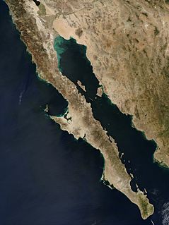
The Baja California peninsula is a long piece of land in northwestern Mexico. It stretches between the Gulf of California and the Pacific Ocean. This peninsula goes from Mexicali, Baja California, in the north all the way to Cabo San Lucas, Baja California Sur, in the south.
It is about 1,247 kilometers (775 miles) long. Its width changes from 40 kilometers (25 miles) at its narrowest to 320 kilometers (200 miles) at its widest. The peninsula has about 3,000 kilometers (1,900 miles) of coastline and around 65 islands. The total area of the Baja California peninsula is 143,390 square kilometers (55,360 square miles).
The Gulf of California and the Colorado River separate the peninsula from mainland Mexico. Baja California has four main desert areas. These are the San Felipe Desert, the Central Coast Desert, the Vizcaíno Desert, and the Magdalena Plain Desert.
Contents
History of Baja California
The name "California" was a myth among European explorers before this land was found. The first known mention of a place called California was in a Spanish novel from 1510. This book described the Island of California as a mythical place. It was said to be near a "Terrestrial Paradise" and lived in by "black women" like Amazons.
Early Spanish explorers first thought the Baja peninsula was an island. They named it California, after the mythical paradise. After Hernán Cortés conquered Mexico, he sent expeditions to find a fabled passage between the Atlantic and Pacific oceans. In 1539, explorer Francisco de Ulloa proved that Baja California was actually a peninsula. He named the water separating it from the mainland the "Vermillion Sea." Today, this body of water is often called the "Gulf of California."
The Spanish called the peninsula and the lands to its north Las Californias. This included both Baja California and Alta California. Alta California later became parts of the U.S. states of California, Nevada, Utah, Arizona, and parts of Colorado and Wyoming.
For a long time, many maps wrongly showed California as an island. This idea spread in the 17th century and lasted into the 18th century. It is thought to have started with a friar named Antonio Ascension around 1620. He drew a map showing California as an island. This map was copied and spread widely, leading to much confusion.
The idea of California as an island was finally disproven by a map made by Italian Jesuit priest Eusebio Kino. In 1701, Kino redrew his map based on his travels and information from native people. His map clearly showed California as a peninsula. This map was printed in 1707 and became very well known.
Key Moments in Baja California's History
- Before European Contact: Many native groups lived in Baja California. These included the Yuman people, Paipai, Kumeyaay, Cochimí, Cocopah, Kiliwa, Guaycura, and Pericú peoples.
- 1532: Hernán Cortés sent ships north to find the "Island of California."
- 1533: A mutiny led to a settlement in the Bay of La Paz.
- 1539: Francisco de Ulloa explored the coasts and confirmed Baja was a peninsula. A cartographer named Domingo del Castillo drew an accurate map of the peninsula.
- 1578 or 1579: The San Juanillo became the first known shipwreck on the California coast.
- Late 1600s–1800s: Spanish settlers and missionaries arrived. The first Spanish missions in Baja California were built by Jesuit missionaries.
- 1701: Eusebio Kino's explorations helped people learn more about the Gulf of California coast.
- 1767: The Jesuits were removed, and Franciscans took over the missions.
- 1769: Franciscans moved north to start new missions in Alta California. The Dominican Order took control of the Baja missions.
- 1804: Las Californias was divided into Alta ("Upper") and Baja ("Lower") California.
- 1821: Mexico gained independence from Spain. The Baja California Territory was created.
- 1848: The Treaty of Guadalupe Hidalgo ended the Mexican-American War. Alta California became part of the United States.
- 1853: William Walker tried to take over Baja California, declaring himself president. Mexican forces made him leave.
- 1931: The Baja California Territory was split into Northern and Southern territories.
- 1952: The Northern territory became the 29th State of Mexico, called Baja California.
- 1973: The 1,700-kilometer (1,056-mile) long Trans-Peninsular Highway (Mexican Federal Highway 1) was completed. This was the first paved road to cross the entire peninsula.
- 1974: The Southern territory became the 31st State of Mexico, Baja California Sur.
- 2000: The most common native languages in Baja were Mixteco, Zapoteco, Náhuatl, Purépecha, and Triqui.
Geology of Baja California
The Baja California peninsula was once part of the North American Plate. This is the large piece of Earth's crust that mainland Mexico still sits on. About 12 to 15 million years ago, a process called the East Pacific Rise began to pull the peninsula away from the North American Plate.
Now, the Baja California peninsula is part of the Pacific Plate. It is slowly moving away from the East Pacific Rise in a north-northwest direction. This movement causes earthquakes and volcanic activity in the region.
There is a notable area of volcanic activity along the coast north of Santa Rosalia, Baja California Sur.
Some of the volcanoes on the peninsula and nearby islands include:
- Cerro Prieto
- The San Quintín Volcanic Field
- Isla San Luis
- Tres Vírgenes
- Isla Tortuga
Scientists have found a 2,000-year-old layer of roots, called peat, up to 4 meters (13 feet) deep under the desert mangroves. This peat layer acts like a sponge, storing carbon from the atmosphere. It also holds a record of how much sea levels have risen over time.
Geography of Baja California
The Peninsular Ranges form the main mountain chain of the peninsula. These mountains were created millions of years ago. They are part of the same mountain chain that formed much of the Sierra Nevada mountains in California, USA.
Some of the main mountain ranges are:
- The Sierra de Juárez in the north.
- The Sierra de San Pedro Mártir, which has the peninsula's highest peak, the Picacho del Diablo.
- The Sierra de la Giganta runs along the Gulf of California.
- The Sierra de la Laguna is an isolated mountain range in the south.
Climate
Most of the Baja California peninsula has a hot desert climate. This means it is very hot and dry. The northern parts have a Mediterranean climate, which means mild, wet winters and hot, dry summers. Some areas also have a hot semi-arid climate.
The two most important capes on the Pacific coast are Punta Eugenia and Cabo San Lázaro.
The Sebastián Vizcaíno Bay is the largest bay in Baja, located on the Pacific coast. Cedros Island is a large island near this bay. Inland from the bay is the Desierto de Vizcaino, a large desert.
The biggest bays along the Gulf of California coast are Bahia de La Paz, where the city of La Paz is located, and Bahia Concepcion.
Ecoregions of Baja California
The peninsula has several different ecoregions, which are areas with unique plants and animals. Most of the peninsula is covered by deserts and xeric shrublands. However, you can find pine-oak forests in the mountains at both the northern and southern ends. The southern tip of the peninsula was once an island, so it has many species similar to those found in tropical Mexico.
Some of the ecoregions include:
- California chaparral and woodlands: Found in the northwestern part of the peninsula, and on Cedros Island and Guadalupe Island.
- Sierra Juárez and San Pedro Mártir pine–oak forests: Located in the higher parts of the northern mountain ranges.
- Sonoran Desert: Extends into the northeastern part of the state.
- Baja California desert: Covers most of the Pacific side of the peninsula.
- Gulf of California xeric scrub: Runs along the Gulf of California side of the peninsula.
- San Lucan xeric scrub: Found in the lowlands of the peninsula's southern tip.
- Sierra de la Laguna dry forests: On the lower slopes of the Sierra de la Laguna mountains.
- Sierra de la Laguna pine–oak forests: At higher elevations in the Sierra de la Laguna.
Tourism in Baja California
Many American and Canadian tourists call the peninsula "Baja." It is famous for its beautiful natural environment. Many ecotourists visit to go whale watching and see migrating California gray whales. Tourists also come to the resorts at the southern tip of the peninsula.
Because it is located between the North Pacific and the Gulf of California, Baja is also known for sports fishing. Since 1967, the peninsula has hosted the Baja 1000. This is a famous off-road race that starts in Ensenada and finishes in La Paz.
See also
 In Spanish: Península de Baja California para niños
 | Emma Amos |
 | Edward Mitchell Bannister |
 | Larry D. Alexander |
 | Ernie Barnes |


