Sierra de la Laguna facts for kids
Quick facts for kids Sierra de la Laguna |
|
|---|---|

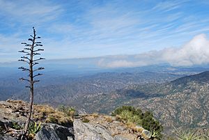
View from El Picacho.
|
|
| Highest point | |
| Peak | Sierra de la Laguna High Point |
| Elevation | 6,857 ft (2,090 m) |
| Geography | |
|
Lua error in Module:Location_map at line 420: attempt to index field 'wikibase' (a nil value).
|
|
| Country | Mexico |
| Geology | |
| Type of rock | Peninsular Ranges |
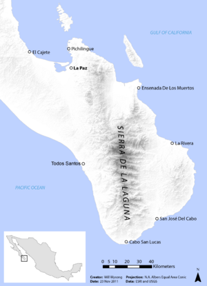
The Sierra de la Laguna is a mountain range located at the southern tip of the Baja California Peninsula in Mexico. It is the southernmost part of a larger group of mountains called the Peninsular Ranges System.
This mountain range is found in the La Paz Municipality and Los Cabos Municipality in the southern part of the Baja California Sur state. The highest point in this range is called the "Sierra de la Laguna High Point". It stands tall at about 2,090 meters (6,857 feet) above sea level. This makes it the highest spot in all of Baja California Sur state.
Contents
Amazing Nature: Plants and Animals
The Sierra de la Laguna area was once an island a very long time ago. Because of this, it has special plants and animals that are found nowhere else. Many of these species are endemic, meaning they only live here.
Unique Plants of the Sierra
Many plants grow only in this region. Some common examples include:
- Bidens cabopulmensis
- Diospyros intricata
- Erythranthe lagunensis
- Heimia salicifolia
- Hibiscus ribifolius
- Indigofera fruticosa
- Physalis glabra
- Quercus brandegeei (a type of oak)
- Sida xanti
- Stenotis asperuloides
- Yucca capensis (a type of yucca plant)
The higher parts of the mountains are home to even more unique plants. These include a rare succulent plant called Dudleya rigida. There is also a type of beargrass known as Nolina beldingii.
Different Forest Types
The Sierra de la Laguna has different types of forests depending on how high up you go:
- The dry San Lucan xeric scrub area is found from the coast up to about 250 meters (820 feet) above sea level.
- The Sierra de la Laguna dry forests are located a bit higher, from 250 meters to 800 meters (820 to 2,625 feet).
- Above 800 meters (2,625 feet), you will find the Sierra de la Laguna pine-oak forests.
The types of trees in the pine-oak forests change with elevation:
- From 800 to 1,200 meters (2,625 to 3,937 feet), oak woodlands are most common.
- Between 1,200 and 1,600 meters (3,937 to 5,250 feet), you will see a mix of oak-pine woodlands.
- Above 1,600 meters (5,250 feet), pine-oak forests take over. The main pine tree here is a special local type of Mexican Pinyon called Pinus cembroides subsp. lagunae.
People use the forests for timber (wood). Also, cattle are raised in the oak woodland and dry forest areas.
Sierra de la Laguna: A Special Reserve
UNESCO has named the Sierra de la Laguna a global biosphere reserve. This means it is a very important natural area that needs protection. It has many different ecosystems, from dry areas to forests with evergreen oaks and pines. It also has oases with palm trees along riverbeds.
The Biosphere Reserve was created by a Mexican law on June 6, 1994. It has a main "core area" that is strictly protected. It also has "buffer zones" around it where people live and work.
The core area protects the high-elevation oak-pine forests. The buffer zones include towns like Todos Santos, El Pescadero, El Triunfo, San Antonio, San Bartolo, Buena Vista, Los Barriles, Las Cuevas, Santiago, and Miraflores, Baja California Sur.
Weather in the Mountains
The weather in the Sierra de la Laguna changes a lot with how high up you are. Higher altitudes have a subtropical highland climate. This means temperatures are cool all year round, and there is more rain.
| Climate data for Sierra de la Laguna, elev. 1,906 metres (6,253 ft) | |||||||||||||
|---|---|---|---|---|---|---|---|---|---|---|---|---|---|
| Month | Jan | Feb | Mar | Apr | May | Jun | Jul | Aug | Sep | Oct | Nov | Dec | Year |
| Record high °C (°F) | 25.0 (77.0) |
26.0 (78.8) |
29.5 (85.1) |
29.0 (84.2) |
32.5 (90.5) |
34.0 (93.2) |
31.0 (87.8) |
36.0 (96.8) |
33.0 (91.4) |
31.0 (87.8) |
29.0 (84.2) |
30.0 (86.0) |
36.0 (96.8) |
| Mean daily maximum °C (°F) | 15.8 (60.4) |
17.2 (63.0) |
19.0 (66.2) |
21.1 (70.0) |
22.7 (72.9) |
24.4 (75.9) |
23.8 (74.8) |
22.9 (73.2) |
22.4 (72.3) |
21.2 (70.2) |
19.0 (66.2) |
17.4 (63.3) |
20.6 (69.1) |
| Daily mean °C (°F) | 8.9 (48.0) |
9.7 (49.5) |
11.2 (52.2) |
13.4 (56.1) |
15.2 (59.4) |
17.8 (64.0) |
18.3 (64.9) |
17.6 (63.7) |
17.1 (62.8) |
15.0 (59.0) |
12.0 (53.6) |
10.2 (50.4) |
13.9 (57.0) |
| Mean daily minimum °C (°F) | 2.1 (35.8) |
2.3 (36.1) |
3.4 (38.1) |
5.7 (42.3) |
7.7 (45.9) |
11.3 (52.3) |
12.9 (55.2) |
12.4 (54.3) |
11.8 (53.2) |
8.8 (47.8) |
5.1 (41.2) |
3.1 (37.6) |
7.2 (45.0) |
| Record low °C (°F) | −7.0 (19.4) |
−7.0 (19.4) |
−6.0 (21.2) |
−4.0 (24.8) |
−1.0 (30.2) |
1.0 (33.8) |
7.0 (44.6) |
5.0 (41.0) |
4.5 (40.1) |
−2.0 (28.4) |
−6.0 (21.2) |
−6.0 (21.2) |
−7.0 (19.4) |
| Average precipitation mm (inches) | 31.1 (1.22) |
10.2 (0.40) |
6.1 (0.24) |
3.0 (0.12) |
0.2 (0.01) |
7.6 (0.30) |
110.8 (4.36) |
181.7 (7.15) |
166.6 (6.56) |
72.4 (2.85) |
18.5 (0.73) |
39.5 (1.56) |
647.7 (25.50) |
| Average precipitation days (≥ 0.1 mm) | 1.92 | 1.32 | 0.78 | 0.37 | 0.18 | 0.90 | 7.62 | 11.91 | 9.45 | 4.65 | 1.86 | 2.60 | 43.56 |
| Average snowy days | 0 | 0.04 | 0 | 0 | 0 | 0 | 0 | 0 | 0 | 0 | 0 | 0 | 0.04 |
| Source 1: Colegio de Postgraduados | |||||||||||||
| Source 2: Servicio Meteorológico National (extremes) | |||||||||||||
See also
 In Spanish: Sierra La Laguna para niños
 | James Van Der Zee |
 | Alma Thomas |
 | Ellis Wilson |
 | Margaret Taylor-Burroughs |


