
East Pacific Rise facts for kids
The East Pacific Rise (EPR) is a huge underwater mountain range found on the floor of the Pacific Ocean. It's a place where Earth's giant tectonic plates are slowly pulling apart. Think of it like a giant crack in the ocean floor where new crust is being made!
This underwater rise separates the Pacific Plate on its west side from several other plates to the east, including the North American Plate, Rivera Plate, Cocos Plate, Nazca Plate, and Antarctic Plate. The East Pacific Rise stretches a very long way, from the Gulf of California near Southern California all the way south to a point where it connects with the Pacific-Antarctic Ridge. Much of this rise is about 3,200 kilometers (2,000 miles) off the coast of South America. It can reach heights of about 1,800 to 2,700 meters (5,900 to 8,900 feet) above the surrounding seafloor.
Contents
How the Ocean Floor Spreads

The ocean floor is constantly moving away from the East Pacific Rise on both sides. This process is called seafloor spreading. It's like a conveyor belt, slowly carrying the new crust away from the center. Near Easter Island, this spreading happens super fast, over 150 millimeters (6 inches) per year! That's one of the fastest rates in the world. However, at the northern end, it's much slower, around 60 millimeters (2.4 inches) per year.
Volcanoes and Plate Collisions
On the eastern side of the East Pacific Rise, the plates moving eastward (like the Cocos and Nazca plates) eventually crash into and slide under the westward-moving South American Plate and North American Plate. This process is called subduction. When one plate slides under another, it causes a lot of friction and heat, leading to volcanoes. That's why you see a long chain of volcanoes along the Andes Mountains in South America and through Central America and Mexico.
Near the Baja California Peninsula, this part of the Rise is sometimes called the Gulf of California Rift Zone. Here, new ocean floor mixes with parts of the North American continent that are being pulled apart.
Amazing Deep-Sea Vents
One of the most exciting discoveries along the East Pacific Rise are the hydrothermal vents, often called "black smokers." These vents were first found in 1979. They are like chimneys on the ocean floor that shoot out super-hot, mineral-rich water. These minerals create huge deposits on the seafloor.
Even more amazing, scientists have found many unique deep-sea creatures living around these vents. These creatures don't need sunlight to survive, unlike most life on Earth. Instead, they get their energy from chemicals released by the vents in a special kind of ecosystem. It's a completely different way of life!
See also
 In Spanish: Dorsal del Pacífico Oriental para niños
Images for kids
-
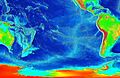
Relief map with the East Pacific Rise (shown in light blue), extending south from the Gulf of California

