Baja California Territory facts for kids
Quick facts for kids Baja California Territory |
|||||||||||||||||||||||
|---|---|---|---|---|---|---|---|---|---|---|---|---|---|---|---|---|---|---|---|---|---|---|---|
| Territory of Mexico | |||||||||||||||||||||||
| 1824–1931 | |||||||||||||||||||||||
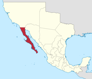
 Location of the Baja California Territory (red) in Mexico, 1824. |
|||||||||||||||||||||||
| Capital | Loreto (1824–1829) La Paz (1829–1931) |
||||||||||||||||||||||
| • Type | Territory of Mexico | ||||||||||||||||||||||
| History | |||||||||||||||||||||||
|
• Created
|
1824 | ||||||||||||||||||||||
|
• Divided
|
1931 | ||||||||||||||||||||||
|
|||||||||||||||||||||||
The Baja California Territory was a part of Mexico from 1824 to 1931. It covered the entire Baja California peninsula in what is now northwestern Mexico. This territory took the place of the Baja California Province, which was part of New Spain under Spanish rule. After Mexico became independent, this area, along with Alta California, was separated from the larger Spanish region known as The Californias.
In 1931, the Baja California Territory was split into two smaller areas: the "North Territory of Baja California" and the "South Territory of Baja California". Later, in 1952, the "North Territory" became the 29th state of Mexico, known as Baja California. Then, in 1974, the "South Territory" also became a state, the 31st, called Baja California Sur.
Contents
How Baja California's Borders Were Set
The northern border of Baja California with Alta California was first drawn to separate areas managed by different religious groups. These groups were the Franciscans and the Dominicans. The exact border was set on August 19, 1773, by a friar named Francisco Palóu. It was located near San Juan Bautista Creek.
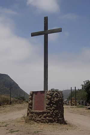
Today, a special marker stands where this old border used to be. It is behind the ruins of a mission called Misión San Miguel Arcángel de la Frontera, in La Misión, Baja California. This line, set by Palóu, became the official dividing line for the provinces in 1804.
Changes to the International Border
In 1848, a new agreement called the Treaty of Guadalupe Hidalgo changed the international border. This new border moved further north to San Diego Bay. This change was based on earlier claims by explorers like Juan Rodríguez Cabrillo and Sir Francis Drake.
The Border Marker's Message
The marker at the old border has an inscription that tells its story. It explains that the San Juan Bautista Creek was chosen on May 1 for the first international division. This line separated Old or Lower California (managed by Dominicans) from New or Upper California (managed by Franciscans).
The inscription also mentions that Priest Francisco Palóu officially set this border on August 19, 1773. This was done following instructions from an agreement made on April 7, 1772. The marker was placed by the Rosarito Historical Society in Baja California on May 20, 1990.
See also
 In Spanish: Territorio de Baja California para niños
- Las Californias Province – This was the Spanish colonial region from 1768 to 1804.
- Baja California Province – The Spanish colonial period from 1804 to 1824.
- Alta California territory – This territory existed from 1824 to 1846. It includes parts of today's California, Nevada, New Mexico, and Utah.
- Spanish missions in Baja California – Learn about the old Spanish missions in this area.
- Colonial Mexico-related topics
- Viceroyalty of New Spain-related topics
 | Lonnie Johnson |
 | Granville Woods |
 | Lewis Howard Latimer |
 | James West |


