
La Paz, Baja California Sur facts for kids
Quick facts for kids
La Paz
|
||
|---|---|---|
 .jpg)    Top: La Paz coastline; middle: Old City Hall (left) and Balandra Beach (right); bottom: Perla de la Paz (pearl of peace) monument (left) and Our Lady of Peace Cathedral (right).
|
||
|
||

La Paz, Baja California Sur
Location in Baja California Sur

La Paz, Baja California Sur
Location in Mexico
|
||
| Country | Mexico | |
| State | Baja California Sur | |
| Municipality | La Paz | |
| Founded | 3 May 1535 | |
| named La Paz | 1596 | |
| Elevation | 27 m (89 ft) | |
| Population
(2020)
|
||
| • Total | 250,141 | |
| Data source: INEGI | ||
| Time zone | UTC−07:00 (MST) | |
| Source: Enciclopedia de los Municipios de México | ||

La Paz (which means "peace" in Spanish) is the capital city of the Mexican state of Baja California Sur. It is also the largest city in the state. In 2020, about 250,141 people lived there. This makes it the most populated city in Baja California Sur.
La Paz City is part of the larger La Paz Municipality. This municipality is one of the biggest in Mexico by land area and population. It covers about 20,275 square kilometers (7,828 square miles).
If you travel by air, you can fly to Manuel Márquez de León International Airport in La Paz. This airport connects to many major cities in Mexico. It also has seasonal flights to Dallas, Texas, and Phoenix, Arizona, in the United States. Two ferry services also run from a port called Pichilingue, which is just outside the city. These ferries connect the Baja California Peninsula to the mainland of Mexico.
Contents
History of La Paz
Early Inhabitants and European Arrival
People first lived in the La Paz area at least 10,000 years ago. These early people were Neolithic hunter-gatherers. They hunted animals and gathered plants for food. They left behind rock paintings near the city and all over the Baja California Peninsula.
On May 3, 1535, the Spanish explorer Hernán Cortés arrived at the bay where La Paz is now. He named it "Santa Cruz." He tried to start a new settlement there. However, he gave up after a few years because it was too hard to get supplies. In 1596, another Spanish explorer, Sebastián Vizcaíno, arrived. He gave the area its current name, La Paz.
A Brief Period as a Capital
For a short time in 1854, La Paz was the capital of a place called the Republic of Sonora. This was a project started by an American named William Walker. But this plan did not last long. It failed because the United States did not support it, and the Mexican government worked to take back the region.
Geography and Location

La Paz is located on the Baja California peninsula next to the Bay of La Paz. It is about 210 kilometers (130 miles) south of Ciudad Constitución. It is also about 202 kilometers (126 miles) north of Cabo San Lucas. The city sits between 0 and 27 meters (0 to 89 feet) above sea level. La Paz is special because it is one of only three state capitals in Mexico that are right on the coast.
Climate and Weather

La Paz has a subtropical desert climate. This means it is usually dry and sunny. The average temperature throughout the year is between 17 and 30 degrees Celsius (63 and 86 degrees Fahrenheit).
In summer (July to September), temperatures are usually between 34 and 36 degrees Celsius (93 and 97 degrees Fahrenheit). In winter (December to February), it is cooler, with temperatures sometimes dropping below 15 degrees Celsius (59 degrees Fahrenheit) at night. However, daytime winter temperatures are usually between 20 and 25 degrees Celsius (68 and 77 degrees Fahrenheit).
Breezes from the Bay of La Paz help keep the city from getting too hot. The bay also helps protect the city from big storms that can happen in the Gulf of California.
Rainfall and Sunshine
La Paz does not get much rain most of the year. When it does rain, it is usually in August and September. This is part of the North American Monsoon season. The driest time is from March to June, when it often does not rain at all. La Paz gets more than 300 sunny days each year.
Unique Winds and Sea Temperatures
During the summer, a special wind called the Coromuel blows at night. This wind is unique to the La Paz area. It comes from the Pacific Ocean, crosses the peninsula, and blows into the Bay of La Paz, helping to cool things down.
The temperature of the water in the Gulf of California changes a lot during the year. In winter, the water is around 20 degrees Celsius (68 degrees Fahrenheit). In summer, it can warm up to about 29 degrees Celsius (85 degrees Fahrenheit).

| Jan | Feb | Mar | Apr | May | Jun | Jul | Aug | Sep | Oct | Nov | Dec |
|---|---|---|---|---|---|---|---|---|---|---|---|
| 68 °F 20 °C |
66 °F 19 °C |
68 °F 20 °C |
72 °F 22 °C |
75 °F 24 °C |
79 °F 26 °C |
82 °F 28 °C |
84 °F 29 °C |
86 °F 30 °C |
84 °F 29 °C |
79 °F 26 °C |
72 °F 22 °C |
Economy and Tourism
_with_open_mouth_in_La_Paz,_Mexico.jpg)
The number of people living in La Paz has grown a lot since the early 2000s. This growth has also helped the city's economy.
Eco-Tourism and Natural Beauty
Eco-tourism is the most important type of tourism in La Paz. This means visitors come to enjoy nature in a way that protects the environment. There are about 900 islands and small inlets in the Gulf of California. Many of these are protected by UNESCO as World Heritage Bio-Reserves. The Isla Espíritu Santo group of islands is a very popular place for tourists. It is located near the northeast part of the Bay of La Paz.
Main Industries
Besides tourism, other important industries in La Paz include silver mining, agriculture (farming), fishing, and pearls. These activities provide many jobs for the people who live in this coastal city.
Transportation in La Paz

La Paz has an airport called Manuel Márquez de León International Airport. You can fly from here to Mexico's biggest cities. There are also flights to major cities in northwest Mexico. Airlines like Aeroméxico Connect, Volaris, VivaAerobus, Calafia, and TAR fly from this airport.
Two ferry services also run from the port of Pichilingue. This port is just outside the city. These ferries connect the Baja California peninsula to the mainland of Mexico. They go to Mazatlán and Topolobampo.
Roads and Highways
The Malecon Road runs along the coast in front of La Paz. It is about 5 kilometers (3 miles) long. This road helps people move easily across the city. It has also become a popular spot for tourists. Many bars, restaurants, and shops are located along this road. Since 2004, a wide sidewalk has been added. This makes it safe for many people to walk along the coast. In 2011, a bike lane was also added to the Malecon Road. This gives cyclists a safe place to ride.
La Paz is connected by two main highways. Mexican Federal Highway 1 goes from Cabo San Lucas in the south to Tijuana in the north. Mexican Federal Highway 19 connects La Paz to towns on the south Pacific coast, like Todos Santos. There are also two smaller roads. The Los Planes highway connects La Paz to towns like La Ventana. The Pichilingue highway links La Paz to its port.
Delicious Cuisine
.jpg)
The food in La Paz is famous for its seafood dishes. You can find delicious lobster, sole fish, clams, and shrimp.
Local Specialties
One traditional dish is machaca. This is made from beef that is cooked well, shredded, and then cooked in its own juices. Fresh cheeses and special flour tortillas are also common. Clams are very popular and are prepared in many ways. They can be pickled, breaded and fried, or stuffed. Shrimp are also plentiful. They are eaten grilled, fried, or baked in a dish called filete imperial de camarones. Other popular seafood dishes include callo garra de león, made with scallops, and fish tatemado. Ceviche is another favorite, made with fresh raw fish or seafood cured in citrus juices.
Sweet Treats
For desserts, people enjoy local fruits like guava, mango, and pitaya. These fruits are often made into syrup. Dried fruits like white fig and mango are also popular. You can also find tasty cheese empanadas (empanadas de queso) and empanadas made with sweet beans.
Population and Demographics

In 2020, the city of La Paz had 250,141 residents. This makes it the most populated city in the state of Baja California Sur. The total population of the municipality is even larger, with about 290,286 people. This includes nearby towns like El Centenario and Chametla. The municipality of La Paz is the fourth largest in Mexico by its geographic size.
Education and Learning
La Paz is not only the state capital and a center for business, but also a hub for learning. It is home to three of the top marine biology institutes in Latin America. These are UABCS, CIBNOR, and CICIMAR. They are located here because the Gulf of California has amazing marine biodiversity (many different kinds of sea life). La Paz also has several other universities and learning centers.
Higher Education Centers
Here are some of the main higher education centers in La Paz:
- Universidad Autónoma de Baja California Sur (UABCS)
- Universidad Tecnológica de La Paz (UTLP)
- Instituto Tecnológico de La Paz (ITLP)
- Universidad Mundial (UM)
- Centro Interdisciplinario de Ciencias Marinas (CICIMAR)
- Centro de Investigaciones Biológicas del Noroeste (CIBNOR)
- Centro de Investigación Científica y de Educación Superior de Ensenada (CICESE) Campus La Paz
- Benemérita Escuela Normal Urbana Prof. Domingo Carballo Félix (BENU)
- Escuela Normal Superior del Estado de Baja California Sur (ENSBCS)
- Universidad Internacional de La Paz (UNIPAZ)
- Universidad de Tijuana Campus La Paz (CUT)
- Tecnológico de Baja California
- Universidad Católica Campus La Paz
- Universidad del Desarrollo Profesional (UNIDEP) Plantel La Paz
- Universidad Intercontinental
- Instituto Mar de Cortés
- Instituto Cultural Tecnológico Cuincacalli (ICTEC)
- Centro de Capacitación para el Trabajo Industrial (CECATI 39)
- Escuela Superior de Cultura Física para Baja California Sur (ESCUFI)
Sister Cities
La Paz has "sister city" relationships with several other cities around the world. These relationships help promote cultural exchange and understanding.
 Ensenada, Mexico
 Redondo Beach, United States
- Rosarito, Mexico
- Tijuana, Mexico
- Tlajomulco de Zúñiga, Mexico
- Alexandria, Virginia, United States
- Clearwater, Florida, United States
 Vigo, Spain
 Saint-Tropez, France
 Düsseldorf, Germany
Images for kids
-
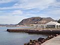
Typical La Paz monolith
-
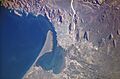
The Bay of La Paz, as seen from the International Space Station. El Mogote peninsula is visible to the center left.
-
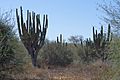
Cardons (P. pringlei) in La Paz outskirts
-
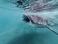
Whale shark snorkeling at La Paz Bay
-
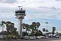
Manuel Márquez de León International Airport
-
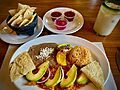
Machaca, a local dish served for breakfast
-
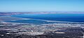
Aerial view towards south La Paz
See also
 In Spanish: La Paz (Baja California Sur) para niños
