Topolobampo facts for kids
Quick facts for kids
Topolobampo
|
||
|---|---|---|
 |
||
|
||
| Nickname(s):
Topo
|
||
| Country | ||
| State | Sinaloa | |
| Municipality | Ahome | |
| Founded in | 1884 | |
| Founded by | Albert K. Owen | |
| Elevation | 10 m (30 ft) | |
| Population
(2010)
|
||
| • Total | 6,361 | |
| Time zone | UTC-7 (Pacific Time zone) | |
| • Summer (DST) | UTC-6 (Pacific Daylight Time) | |
| Website | Official page: http://www.puertotopolobampo.com.mx | |
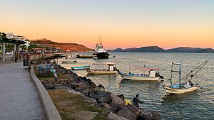
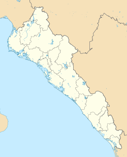
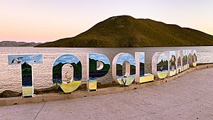
Topolobampo is an important port town in northwestern Sinaloa, Mexico. It is located on the Gulf of California. In 2010, about 6,361 people lived there. It is the fourth-largest town in the Ahome area.
This port helps connect the northern parts of Mexico. It is the end point for the Chihuahua-Pacific Railroad. This railway links Topolobampo to other states. A daily car ferry also leaves from here. It travels to La Paz in Baja California Sur.
Topolobampo is also the start of a big trade route. This route is called "La Entrada al Pacifico". It stretches all the way to the Midland-Odessa area in Texas, USA.
Contents
A Look at Topolobampo's Past
Topolobampo was once the site of a special community. It was a "utopian" colony, which means people tried to create a perfect society there. This idea was inspired by Henry George's economic thoughts.
The founder of Topolobampo was Albert K. Owen. He believed in a community where everyone worked together. They wanted to share public services and make sure everyone was healthy and useful.
This group even published a newsletter in English. It was called The Credit Foncier of Sinaloa. It talked about their ideas for collective ownership. One old copy of this newsletter still exists today.
Topolobampo's Location and Weather
Climate and Temperatures
Topolobampo has a very dry desert climate. This means it gets very little rain. The weather is usually warm or hot all year round.
| Climate data for Topolobampo (1951–2010) | |||||||||||||
|---|---|---|---|---|---|---|---|---|---|---|---|---|---|
| Month | Jan | Feb | Mar | Apr | May | Jun | Jul | Aug | Sep | Oct | Nov | Dec | Year |
| Record high °C (°F) | 39.0 (102.2) |
39.0 (102.2) |
38.0 (100.4) |
38.0 (100.4) |
39.0 (102.2) |
40.0 (104.0) |
41.0 (105.8) |
43.5 (110.3) |
41.0 (105.8) |
43.0 (109.4) |
38.5 (101.3) |
37.0 (98.6) |
43.5 (110.3) |
| Mean daily maximum °C (°F) | 24.8 (76.6) |
25.8 (78.4) |
27.5 (81.5) |
29.6 (85.3) |
32.0 (89.6) |
34.1 (93.4) |
35.0 (95.0) |
34.8 (94.6) |
34.2 (93.6) |
32.9 (91.2) |
29.3 (84.7) |
25.6 (78.1) |
30.5 (86.9) |
| Daily mean °C (°F) | 19.2 (66.6) |
20.1 (68.2) |
21.7 (71.1) |
23.9 (75.0) |
26.5 (79.7) |
29.5 (85.1) |
30.6 (87.1) |
30.4 (86.7) |
29.9 (85.8) |
28.1 (82.6) |
24.0 (75.2) |
20.4 (68.7) |
25.4 (77.7) |
| Mean daily minimum °C (°F) | 13.7 (56.7) |
14.4 (57.9) |
16.0 (60.8) |
18.2 (64.8) |
21.0 (69.8) |
24.9 (76.8) |
26.2 (79.2) |
25.9 (78.6) |
25.6 (78.1) |
23.3 (73.9) |
18.7 (65.7) |
15.2 (59.4) |
20.3 (68.5) |
| Record low °C (°F) | 5.0 (41.0) |
8.0 (46.4) |
9.0 (48.2) |
11.0 (51.8) |
12.0 (53.6) |
17.0 (62.6) |
20.0 (68.0) |
18.0 (64.4) |
15.0 (59.0) |
14.0 (57.2) |
11.0 (51.8) |
5.5 (41.9) |
5.0 (41.0) |
| Average precipitation mm (inches) | 12.1 (0.48) |
3.8 (0.15) |
0.6 (0.02) |
0.0 (0.0) |
0.8 (0.03) |
1.9 (0.07) |
57.7 (2.27) |
96.1 (3.78) |
66.6 (2.62) |
31.9 (1.26) |
19.0 (0.75) |
22.1 (0.87) |
312.6 (12.31) |
| Average precipitation days (≥ 0.1 mm) | 1.3 | 0.7 | 0.2 | 0.0 | 0.1 | 0.2 | 3.8 | 5.4 | 3.9 | 1.9 | 1.1 | 1.4 | 20.0 |
| Source: Servicio Meteorologico Nacional | |||||||||||||
Ocean Temperatures
The sea water around Topolobampo changes temperature throughout the year. In winter, the water is cooler, around 19 to 20 degrees Celsius. In the summer, it gets much warmer, reaching 29 to 31 degrees Celsius.
| Jan | Feb | Mar | Apr | May | Jun | Jul | Aug | Sep | Oct | Nov | Dec |
|---|---|---|---|---|---|---|---|---|---|---|---|
| 20 °C
68 °F |
19 °C
66 °F |
20 °C
68 °F |
22 °C
72 °F |
25 °C
77 °F |
27 °C
81 °F |
29 °C
85 °F |
31 °C
88 °F |
31 °C
88 °F |
29 °C
84 °F |
25 °C
77 °F |
21 °C
70 °F |
See also
 In Spanish: Topolobampo para niños
 | William Lucy |
 | Charles Hayes |
 | Cleveland Robinson |


