
Mazatlán facts for kids
Quick facts for kids
Mazatlán
|
|||
|---|---|---|---|
|
City and Municipality
|
|||

From upper left: Hotel Zone, Monument to Mazatleca women, Mazatlán pier, Cordones Island, Mazatlán Cathedral, Panoramic view of the city
|
|||
|
|||
| Nickname(s):
Pacific Pearl, Fish Land
|
|||

Mazatlán
Location in Sinaloa

Mazatlán
Location in Mexico
|
|||
| Country | Mexico | ||
| State | Sinaloa | ||
| Municipality | Mazatlán | ||
| Settled | 14 May 1531 | ||
| Area | |||
| • Municipality | 3,068.5 km2 (1,184.75 sq mi) | ||
| Elevation | 10 m (33 ft) | ||
| Highest elevation
(Crestón Island)
|
157 m (515 ft) | ||
| Lowest elevation | 0 m (0 ft) | ||
| Population | |||
| • City | 381,583 | ||
| • Density | 143/km2 (370/sq mi) | ||
| • Municipality | 501,441 | ||
| Demonym(s) | Mazatleco, Mazatleca | ||
| GDP (PPP, constant 2015 values) | |||
| • Year | 2023 | ||
| • Total (Metro area) | $9.2 billion | ||
| • Per capita | $19,200 | ||
| Time zone | UTC−7 (MST) | ||
| Postal code |
82000
|
||
| Area code(s) | 669 | ||
| Climate | Aw | ||
| Waterways | Estero del Infiernillo, Laguna del Camarón, Estero del Yugo | ||
| Airports | Mazatlán International Airport | ||
| Public transit | Autotransportes Águilas del Pacífico | ||
| Railroads | Ferromex Mazatlán Station | ||


Mazatlán is a city in the Mexican state of Sinaloa. It is the main city for the surrounding area, called the Mazatlán Municipality. You can find it on the Pacific coast. It is right across from the southern tip of the Baja California Peninsula.
The name Mazatlán comes from the Nahuatl language. It means "place of deer." Spanish explorers settled the city in 1531. Many native people already lived there. In the mid-1800s, many immigrants from Germany arrived.
Over time, Mazatlán grew into a busy seaport. It imported tools for the gold and silver mines nearby. From 1859 to 1873, it was the capital of Sinaloa. The German settlers also influenced the local music, called banda. Some of this music sounds like Bavarian folk music. The settlers also started the Pacifico Brewery in 1900.
Mazatlán has a rich culture and art scene. It has the Angela Peralta Theater. There are also many art galleries, museums, and historic buildings.
In 2010, Mazatlán was the second-largest city in Sinaloa. The city had 438,434 people. The whole municipality had 489,987 people. It is also a popular place for tourists. Its beaches have many resort hotels. A car ferry travels across the Gulf of California from Mazatlán to La Paz, Baja California Sur. The municipality covers about 3,068 square kilometers (1,185 square miles). It includes smaller towns like Villa Unión and El Quelite. General Rafael Buelna International Airport serves Mazatlán.
Contents
- What Does Mazatlán Mean?
- A Look at Mazatlán's Past
- Nearby Communities
- Mazatlán's Geography
- Mazatlán's Economy
- Delicious Food in Mazatlán
- The Mazatlán Boardwalk
- Mazatlán Aquarium
- Mazatlán Lighthouse
- Banda Sinaloense Music
- Popular Beaches
- Fun Things to Do and See
- Sports in Mazatlán
- Getting Around Mazatlán
- Schools and Universities
- Famous People from Mazatlán
- Images for kids
- Sister Cities
- See also
What Does Mazatlán Mean?
The name Mazatlán comes from the Nahuatl language. It means "Land of deer." The word "mazatl" means "deer." "Tlan" means a place with lots of something.
The area was first called Presidio of Mazatlán. This was for what is now Villa Unión. The port was known as the Islands of Mazatlán. In 1828, Presidio of Mazatlán was renamed Villa of the Union. This made the name Mazatlán free. Since the port was called Islas de Mazatlán, the name was then used for the port city.
A Look at Mazatlán's Past
Early Times
Native groups lived in the Mazatlán area before the Spanish arrived. These groups included the Totorames and the Xiximes. The Codex Mendoza says the Aztec Empire conquered this region.
Spanish Rule
The Spanish first came to Sinaloa in 1531. They settled the city of Mazatlán that same year. In 1534, the Valley of Mazatlán was divided. In 1576, Captain Martín Hernández was sent to take over Mazatlán. He was given land and titles.
In 1565, the town of Chametla was attacked by native groups. Captain Francisco de Ibarra rebuilt Chametla. He also founded Villa de San Sebastián, now called Concordia.
By 1749, Sinaloa was divided into five areas. Mazatlán was part of the Copala area.
Independent Mexico
In 1821, Mazatlán was named the first port on Mexico's Pacific coast. At first, Mazatlán was a small fishing village. It had huts where native people lived.
_-_MAZATLAN,_MEXICO.jpg)
In 1829, a banker named Juan Nepomuceno Machado arrived. He started trading with ships from many places. These included Chile, Peru, the United States, Europe, and Asia Pacific. By 1836, the city had 4,000 to 5,000 people. It became the biggest port on the Mexican Pacific coast.
During the Mexican-American War in 1846, the U.S. military took over Mazatlán. In 1859, the British blocked the port. French forces took Mazatlán in 1864. They were later forced out in 1866.
During the California Gold Rush, people from the eastern U.S. sailed to Mexican ports. They would then travel by land to Mazatlán. From there, they would sail to San Francisco.
Culiacán was the capital of Sinaloa until 1853. Then, Mazatlán became the capital. But in 1867, a law said state capitals could not also be ports. So, in 1873, Culiacán became the capital again.
The Porfiriato Era
.jpg)
.jpg)
.jpg)
Mazatlán's lighthouse started working in 1879. Its light could be seen far away. By 1905, it became a revolving light. At that time, it was thought to be the highest natural lighthouse in the world. Today, its powerful bulb can be seen for 30 nautical miles (56 km). Near the lighthouse, "divers" jump from high rocks into the ocean for tips.
In 1880, Jesus Ramirez and his men took over Mazatlán. The city was then bombed by a Mexican warship. Many people were hurt.
Angela Peralta (1845–1883), a famous opera singer, died in Mazatlán from yellow fever. The Angela Peralta Theater keeps her memory alive.
The Cerveceria del Pacífico (Pacific Brewery) was founded in 1900 by German immigrants.
Mexican Revolution Times
.jpg)
In 1915, Mazatlán became an independent municipality. The Constitution of 1917 confirmed this.
Mazatlán was one of the first cities in the world to be bombed from the air. During the Mexican Revolution, General Venustiano Carranza ordered a plane to drop a bomb. The bomb was made of nails and dynamite. It missed its target and landed on city streets. Two people died, and several were hurt.
Modern Mazatlán
.jpg)
Mazatlán is the hometown of Pedro Infante. He was a very popular actor and singer.
Famous film stars like John Wayne and Gary Cooper loved Mazatlán. They came for sportfishing in the 1940s, 50s, and 60s. Hotels along Olas Altas were very popular then.
In the 1970s, new hotels opened north of the city. This area is called "Zona Dorada." The old part of Mazatlán became less popular for tourists.
Other famous people from Mazatlán include actresses Lorena Herrera and Sabine Moussier. Hollywood actress Sara Ramirez was also born here.
In the 2000s, the Historic Center was rediscovered. Many old homes were fixed up. The city also improved water, sewer, and electricity services.
Mazatlán experienced two total solar eclipses. One was on July 11, 1991. The other was on April 8, 2024. It was the first city in North America to see the 2024 eclipse.
Nearby Communities
Mazatlán is divided into nine main areas called syndicates:
- Mazatlán: This is the main city. It is the biggest and most important tourist spot.
- Villa Union: This town is 25 km (15.5 miles) from Mazatlán. It is the second most important town in the area. People here work in fishing, farming, and making bricks.
- El Recodo: This town is known for being the home of Don Cruz Lizarraga. He founded the famous Banda El Recodo. People here raise animals, farm, and make leather goods.
- El Quelite: This is a pretty tourist town 38 km (23.6 miles) northwest of Mazatlán. Its houses show Spanish style. People here practice charrería (Mexican rodeo) and a game called Ulama.
- Mármol de Salcido: This town is 32 km (19.9 miles) from Mazatlán. It used to make cement. Now, it grows chilies and tomatoes. It has many beautiful beaches.
- El Roble: Founded in 1867, it is 32 km (19.9 miles) from Mazatlán. It used to have the biggest sugar mill in the south. Now, it focuses on farming, cheese, and honey.
- Siqueiros: This town was founded in 1749. It is 29 km (18 miles) from Mazatlán. Its main activities are farming and growing vegetables.
- La Noria: Located 35 km (21.7 miles) northwest of Mazatlán. Its first settlers arrived in the late 1500s. People here raise animals and make leather goods. It is near the Vinata de Los Osuna, which makes blue agave.
- El Habal: This village is 10 km (6.2 miles) north of Mazatlán. Its people raise animals, farm, and grow fruits.
Mazatlán's Geography

Mazatlán is in southern Sinaloa. It covers about 3,068.5 square kilometers (1,185 square miles). This makes it Sinaloa's ninth-largest area. To the north, it borders San Ignacio and Durango. To the south, it borders El Rosario and the Pacific Ocean. To the east, it borders Concordia. To the west, it borders the Pacific Ocean.
The city is about 10 meters (33 feet) above sea level.
Land Features
The land in Mazatlán has hills from the Sierra Madre Occidental mountains. These hills go towards the Pacific Ocean. Some important hills are Vigia, Punta de Materén, and Monte chair.
Water Features

The El Quelite River and several streams flow through Mazatlán. These include the Zapote, La Noria, and Los Cocos streams. They get much bigger during the rainy season.
The El Quelite River flows for 100 kilometers (62 miles). It then empties into the Pacific Ocean. The Zapote and Los Cocos streams flow into the Presidio River.
The Presidio River starts in Durango. It flows for 167 kilometers (104 miles). It passes through towns like Villa Unión.
The Coastline
.jpg)
Mazatlán's coast stretches for about 80 kilometers (50 miles). It has sandy beaches. The coast also has gravel and rock formations.
The Huizache Lagoon is in the southwestern part. It covers 4,000 hectares (40 square miles). It gets water from the ocean and the Presidio River.
The coastline is important for fishing. Many boats catch shrimp and other fish here.
Mazatlán has several islands. Bird Island is about 0.4 square kilometers (0.15 square miles). Deer Island is about 1.85 kilometers (1.15 miles) long. Crestón Island is 700 meters (2,300 feet) long. Goats Island is over 50 meters (164 feet) high.
Stone Island is the biggest part of the coast. It is actually a peninsula. It connects to the mainland near the Mazatlán International Airport. It covers 30 square kilometers (11.6 square miles).
Weather in Mazatlán
Mazatlán is just south of the Tropic of Cancer. It has a tropical savanna climate. This means it has a long dry season. The average yearly temperature is 25 °C (77 °F).
In summer, it feels much hotter because of the humidity.
Mazatlán gets about 748 mm (29.4 inches) of rain each year. Most of this rain falls in July, August, and September. The winds usually come from the northwest.
| Climate data for Mazatlán (1981–2000) | |||||||||||||
|---|---|---|---|---|---|---|---|---|---|---|---|---|---|
| Month | Jan | Feb | Mar | Apr | May | Jun | Jul | Aug | Sep | Oct | Nov | Dec | Year |
| Record high °C (°F) | 33.0 (91.4) |
35.7 (96.3) |
33.0 (91.4) |
38.9 (102.0) |
33.8 (92.8) |
38.1 (100.6) |
37.0 (98.6) |
36.0 (96.8) |
39.0 (102.2) |
35.4 (95.7) |
35.1 (95.2) |
31.4 (88.5) |
39.0 (102.2) |
| Mean daily maximum °C (°F) | 25.4 (77.7) |
25.7 (78.3) |
26.2 (79.2) |
27.8 (82.0) |
29.5 (85.1) |
32.1 (89.8) |
32.8 (91.0) |
32.9 (91.2) |
32.7 (90.9) |
32.2 (90.0) |
29.5 (85.1) |
26.8 (80.2) |
29.5 (85.0) |
| Daily mean °C (°F) | 20.1 (68.2) |
20.4 (68.7) |
21.1 (70.0) |
22.9 (73.2) |
25.4 (77.7) |
28.6 (83.5) |
29.1 (84.4) |
29.1 (84.4) |
29.0 (84.2) |
27.9 (82.2) |
24.5 (76.1) |
21.8 (71.2) |
25.0 (77.0) |
| Mean daily minimum °C (°F) | 14.9 (58.8) |
15.1 (59.2) |
16.0 (60.8) |
18.1 (64.6) |
21.3 (70.3) |
25.0 (77.0) |
25.5 (77.9) |
25.3 (77.5) |
25.2 (77.4) |
23.6 (74.5) |
19.4 (66.9) |
16.7 (62.1) |
20.5 (68.9) |
| Record low °C (°F) | 7.5 (45.5) |
9.5 (49.1) |
10.4 (50.7) |
7.9 (46.2) |
12.8 (55.0) |
19.0 (66.2) |
20.4 (68.7) |
14.9 (58.8) |
20.3 (68.5) |
17.8 (64.0) |
12.0 (53.6) |
9.3 (48.7) |
7.5 (45.5) |
| Average precipitation mm (inches) | 41.9 (1.65) |
8.8 (0.35) |
2.4 (0.09) |
5.2 (0.20) |
1.9 (0.07) |
20.6 (0.81) |
175.8 (6.92) |
230.6 (9.08) |
174.1 (6.85) |
66.5 (2.62) |
46.6 (1.83) |
25.9 (1.02) |
800.3 (31.49) |
| Average precipitation days (≥ 0.1 mm) | 2.3 | 1.0 | 0.5 | 0.6 | 0.1 | 2.0 | 10.2 | 11.0 | 10.5 | 3.5 | 2.1 | 2.2 | 46 |
| Average relative humidity (%) | 64 | 61 | 57 | 54 | 55 | 60 | 70 | 80 | 82 | 69 | 65 | 67 | 65 |
| Mean monthly sunshine hours | 215.6 | 224.8 | 257.3 | 255.1 | 297.0 | 271.5 | 223.4 | 233.6 | 215.3 | 248.0 | 241.5 | 205.7 | 2,888.8 |
| Source 1: SMN | |||||||||||||
| Source 2: NOAA (sun 1961–1990) | |||||||||||||
Plants and Animals of Mazatlán
Mazatlán's plants include tabachines, eucalyptus, laurels, and poplars. Its animals include ducks, herons, and pelicans. You can also find armadillos and raccoons. The ocean has whales, dolphins, turtles, and many fish. The white-tailed deer is a special animal for Mazatlán. Sadly, there are fewer animals and plants now because of human changes.
Mazatlán has protected areas for plants and animals. One is the CACAXTLA Plateau. It has many coastal habitats. This area is home to 66 species of plants and animals that are protected. Many of these are found only in Sinaloa. The people living here depend on these natural resources.
Mazatlán's Economy
Tourism and fishing are the main jobs in Mazatlán. The city has many beach resorts. It also has the second-largest fishing fleet in Mexico. Shrimp and tuna are the most common seafood products.
The first hotel with a restaurant opened in 1850. It was called Canton La Fonda. Today, Mazatlán has over 20 miles (32 km) of beaches. These are the main attraction. There are many hotels, restaurants, bars, and shops. The city also has the Pacífico brewery, a coffee factory, and two power plants.
Delicious Food in Mazatlán

Mazatlán's food is mostly seafood. Popular dishes include ceviches and seafood cocktails. You can also try zarandeado fish and aguachile. Other common foods are smoked marlin and tuna. Don't forget chilorio and bearded tamales (made with shrimp). Governor tacos, fish crackers, and Sinaloa-style grilled chicken are also favorites.

There are also restaurants with food from Japan, Italy, and China. You can find fast food, vegetarian options, and many taco stands.
For drinks, try fresh horchata, barley water, or coconut water. Tejuino is another local drink. The most famous beer is Pacífico, made right in the city. "Tonicol" is a vanilla-flavored drink.
Sweet treats include coconut candies and jamoncillos. These are candies made from coconut marshmallows.
The Mazatlán Boardwalk
The Malecón, or boardwalk, in Mazatlán is one of the longest in the world. It stretches about 8.5 km (5.3 miles) along the Pacific coast. Along the Malecón, you can see high cliffs, monuments, and historic buildings. There are also hotels and roundabouts.
The Malecón has different sections, each with its own name:
- Calz. Joel Montes Camarena: This part connects the lighthouse to the city.
- Paseo del Centenario: This section borders the lookout hill. It was built to celebrate 100 years of Mexican Independence.
- Paseo Olas Altas: This is the oldest part of the boardwalk. It was first built to stop floods in the 1830s. Later, it became a fun place to visit. It was the first part of the city to have streetlights.
- Paseo Claussen: Built in 1910, it ends at the Puerto Viejo bay. It is named after George Claussen, who helped with the project.
- Avenida del Mar: This is the longest and most famous part of the boardwalk. It runs along the Puerto Viejo bay. It leads to the Golden Zone, which is the main hotel area.
Mazatlán Aquarium
The Mazatlán Aquarium opened in 1980. It was one of the best aquariums in Latin America. It had two main parts: the Aquarium and the Botanical Garden.
The Aquarium had exhibits for marine fish, jellyfish, and sharks. You could even swim with sharks! There were also turtles and many other fish species. The Museum of the Sea showed shells and other marine items.
The Botanical Garden had one hectare (2.5 acres) of land. It had 75 tree species from around the world. It also had local plants from Sinaloa. There was a sea lion pond and a frog pond. An oceanic fishbowl held 50 species, including sharks and rays. The aviary had 13 bird species from Sinaloa. There were also crocodiles, owls, snakes, and other animals.
On May 30, 2023, the Gran Acuario Mazatlán opened. It replaced the old aquarium. It is now the largest aquarium in Latin America.
Mazatlán Lighthouse


The Mazatlán lighthouse, called El Faro, is on top of Cerro del Crestón. This is a hill at the southern end of Mazatlán. The lighthouse is on what used to be an island. It is 157 meters (515 feet) high. This makes it the highest natural lighthouse in the Americas. It is also one of the highest working lighthouses in the world.
In 1821, Mazatlán was named the first major port on Mexico's Pacific coast. This meant more ships came to trade. Many ships from Europe and Asia arrived each year. They brought goods and left with gold and silver from the mines.
At night, it was hard for ships to find the port. So, in 1828, a light was put on Isla de Crestón. At first, it was just a small fire fueled by whale oil or wood. This light was dim and hard to see.
El Faro, the new lighthouse, was first lit in 1879. Its lamp was made in Paris. It used an oil lamp with mirrors and a special lens. This made the light much brighter and easier to see. Ships could now find the port more safely.
In 1905, the lamp was changed to use hydrogen gas. It also began to revolve. In 1933, it was changed to electricity. Today, it uses a 1,000-watt bulb and a Fresnel lens.
Now, El Faro is a top tourist spot. People can hike up to see it. The view from the lighthouse is amazing.
Banda Sinaloense Music

Banda Sinaloense, or Tambora, is a type of music and band. It started in Sinaloa in the early 1900s. It comes from European Fanfare music. Banda groups play many kinds of music. These include rancheras, corridos, polkas, and waltzes. They also play romantic ballads and Cumbia.
The sound of Sinaloa band music is like German and French wind instrument bands. There are small differences in style between the north and south of Sinaloa. Some say German immigrants influenced the music in Mazatlán. Others believe it came from military bands and native groups.
Famous bands like La Banda El Recodo started in 1938. It had a strong German influence. Other bands, like La Banda Los Tacuichamona (1888), used only wind instruments and percussion.
Popular Beaches
- Olas Altas: This beach is very historic for Mazatlán. It is in the southern part of the city, near downtown. It is about 550 meters (1,800 feet) long. Along its boardwalk, you can see monuments like The Shield and The Deer. There are also statues for Pedro Infante and Mazatleca Women.
- Norte Beach: This beach is along the northwest edge of downtown. Here, you can find monuments to Fishermen and Pulmonias. Pulmonias are special taxis in Mazatlán. There is also a monument to the Pacific Brewery.
- Sábalo Beach: This long beach runs along Camaron Sabalo and the Malecon. It goes from the Fishermen's Monument to the marina jetty.
- Cerritos Beach: This beach starts at the "new" marina. It runs north to Cerritos point. This is a rocky area near the Emerald Bay resort.
- Isla de la Piedra Beach: This beach is miles long. It is in the southern part of the city on a peninsula. You can get there by car or by small passenger ferries from the historic center.
Fun Things to Do and See
Historic Center
The Historic Center of Mazatlán was named a National Heritage site in 2001. Many people from France, Germany, China, Italy, Spain, and the U.S. used to live here. Locals and groups have worked to restore this area.
Important buildings and places include the Cathedral and Plazuela Machado. There is also the Angela Peralta Theater. The old Hotel Iturbide is now the Municipal Arts Centre. Many other historic homes and buildings are here too.
Culture and Art Events
Mazatlán hosts many events each year. The biggest is the International Carnival of Mazatlán. In 2012, it was 114 years old. Other events include the Mazatlán Cultural Festival and the José Limón International Dance Festival. There are also book fairs.
The International Motorcycle Week brings thousands of motorcyclists. It happens every year during Easter week.
For sports, Mazatlán hosts the Pacific International Triathlon in April. The Pacific International Marathon is in late November or early December. Athletes from all over the world come to these events.
In 2012, Mazatlán hosted the Premios Oye! music awards. It also hosted Olympic volleyball qualifiers.
Mazatlán Carnival
This is one of Mexico's most important carnivals. The first parade on Sunday brings over 600,000 people. It lasts for more than three hours along the "Avenida del Mar."
A fun tradition is "Burning of humor." People burn a large figure (Monigote) that represents someone who has done wrong. This often includes politicians.
After this, there is the "Naval Combat." This show re-enacts a battle against French ships.
Giant "Monigotes" are placed around the city as decorations. These are huge figures made of paper mache. The carnival also crowns a queen. There are two big parades with colorful floats. Many people, including special guests and celebrities, attend.
The Mazatlán Carnival is special because of its Banda Sinaloa music. It also includes cultural events like poetry contests and art shows.
Stone Island (La Isla de la Piedra)
Stone Island, or La Isla de la Piedra, started in 1936. It is famous in Mexico for its long sandy beaches. It also has Mexico's third-largest coconut grove.
People on the island mainly work in fishing and transportation. They bring many tourists and locals to the island. You can get there by ferry, water taxi, or by driving. On the island, you can go on boat trips, swim, or ride horses.
Sports in Mazatlán
Baseball is very popular in Mazatlán. The local team is called Venados de Mazatlán. They play in the Mexican Pacific League. Their season runs from October to December. Playoffs are in January. The winning team represents Mexico in the Caribbean Series.
In Basketball, the team is also called Venados de Mazatlán. They play in the CIBACOPA league. Their season is from March to June.
Soccer has been played here for over 25 years. On June 2, 2020, the Liga MX club Monarcas Morelia moved to Mazatlán. They now play in a new stadium. The team is now called Mazatlán F.C..
Mazatlán is a big sports center. It hosts important events like the marathon and triathlon. Athletes from all over the world come to compete.
One of the first cricket teams was the Mazatlán Redskins. Now, they play American football, soccer, and volleyball.
Getting Around Mazatlán
The General Rafael Buelna International Airport (IATA Code: MZT) has daily flights. You can fly to other parts of Mexico, the United States, and Canada.
By land, Mazatlán is connected to the north (Culiacán) and south (Tepic). It also connects to Guadalajara. You can use highway 15 or the faster Federal Highway 15D. To the east, Highway 40 and Federal Highway 40D connect to Durango.
Ferries travel daily to La Paz, Baja California Sur. Many cruise ships also visit the port each week from the United States.
The Durango-Mazatlán Highway
The Durango-Mazatlán highway links Mazatlán and Durango. It crosses the Sierra Madre Occidental mountains.
Here are some cool facts about it:
- It is 230 km (143 miles) long.
- It has 63 tunnels.
- It has 115 bridges, including the amazing Baluarte Bridge.
- It has two-lane and four-lane sections.
- It cost about 28.6 billion pesos to build.
- It created many jobs.
- The Baluarte Bridge is 1,124 meters (3,688 feet) long.
- The "The Sinaloa" tunnel is 2,794 meters (9,167 feet) long.
This highway cut travel time from 6-8 hours down to just 3 hours!
Pulmonias are a common way to get around Mazatlán. These are like golf cart taxis. They were created in Mazatlán.
Schools and Universities
In the 1840s, foreign traders helped open the first public school in Mazatlán. By 1872, there were only two primary schools. In 1873, Liceo Rosales was founded. This later became the Autonomous University of Sinaloa.
Mazatlán has many schools, from preschools to universities. These include both public and private schools. The Autonomous University of Sinaloa is the biggest public university. Other public universities are the University of the West and the Polytechnic University of Sinaloa.
Private universities include Mazatlán Institute of Technology and Nautical School of Mazatlán. Also, TecMilenio University, Autonomous University of Durango, and Sinaloa Superior Institute of Technology.
The National Autonomous University of Mexico, UNAM, has a unit here. It focuses on marine sciences and food research.
Famous People from Mazatlán
- Eden Estrada, model and social media influencer
- Pedro Infante, famous actor and singer
- Jorge Orta, former baseball player for the Chicago White Sox and Kansas City Royals
- José Urquidy, current baseball pitcher for the Houston Astros and World Series Champion
- Sara Ramirez, Hollywood and Broadway actress
Images for kids
-

Monument to Mazatleca women
-
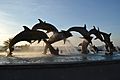
Monument to the Continuity of Life
-
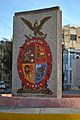
Coat of Sinaloa in Olas Altas
-
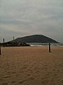
Playa
-

Easter Sunset
-
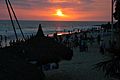
Easter Sunset at Playa Mazatlán
-

Sunset at the El Pescador Playa Norte monument
-

Parasailing near the Hotel Playa Mazatlán
-
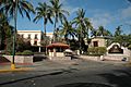
Main entrance to the Hotel Playa Mazatlán
-
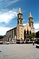
Cathedral in the downtown
-
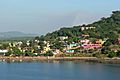
Isla de la Piedra
-
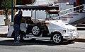
Pulmonia


.jpg)
Sister Cities
 Hamm, North Rhine-Westphalia, Germany
 Santa Monica, California, United States
- Seattle, Washington, United States
- San Ysidro, San Diego, California, United States
- Tucson, Arizona, United States
 Puntarenas, Puntarenas Province, Costa Rica
 Grande Prairie, Alberta, Canada
 Ensenada, Baja California, Mexico
- Tijuana, Baja California, Mexico
- Pico Rivera, California, United States
See also
 In Spanish: Mazatlán para niños
