
North Rhine-Westphalia facts for kids
Quick facts for kids
North Rhine Westphalia
Nordrhein-Westfalen
|
|||
|---|---|---|---|
|
|||
 |
|||
| Country | Germany | ||
| Capital | Düsseldorf | ||
| Area | |||
| • Total | 34,084 km2 (13,160 sq mi) | ||
| Population | |||
| • Total | 18,033,000 | ||
| • Density | 529.075/km2 (1,370.30/sq mi) | ||
| Time zone | UTC+1 (CET) | ||
| • Summer (DST) | UTC+2 (CEST) | ||
| Website | nrw.de | ||


North Rhine-Westphalia (German: Nordrhein-Westfalen) is a federal state in Germany. It is the most populated state in Germany, with over 18 million people. Its capital city is Düsseldorf. This state is located in western Germany.
Contents
History of North Rhine-Westphalia
North Rhine-Westphalia has a long and interesting history. It was formed by joining different regions with their own pasts.
Ancient Times in the Rhineland
The first records of this area come from Julius Caesar, a famous Roman leader. Around 50 BC, he wrote about tribes living on both sides of the Rhine river. The Eburones lived west of the Rhine, and the Ubii and Sugambri lived to the east.
The Romans built many forts along the Rhine. They wanted to control the area, but they never fully took over the lands east of the river. As the Roman Empire grew weaker, new groups called the Ripuarian Franks took control of the region. By the 700s, the Franks ruled western Germany.
The Frankish and Holy Roman Empires
The Franks, led by dynasties like the Merovingians and Carolingians, built a large empire. This empire eventually included the Ripuarian Franks and the Saxons to the north.
When the Carolingian Empire split, the land east of the Rhine became part of East Francia. The land to the west stayed with the kingdom of Lotharingia. By the time of Otto I (who died in 973), both sides of the Rhine were part of the Holy Roman Empire.

Over time, the Holy Roman Emperor's power lessened. The Rhineland broke into many smaller, independent areas. These areas often had their own leaders and histories. Even though it was divided, the Rhineland was a very important place for German culture and progress.
Westphalia's Past
Around AD 1, the Romans explored Westphalia. The famous Battle of the Teutoburg Forest happened near Osnabrück. Some of the Germanic tribes who fought in this battle came from Westphalia.
Charlemagne, another important Frankish emperor, spent time in Paderborn. His wars against the Saxons also took place in Westphalia. A famous Saxon leader named Widukind is linked to many places in Westphalia.
Westphalia was first a district of the Duchy of Saxony. In 1180, it became a duchy itself. The Duchy of Westphalia was a small area south of the Lippe River.
.jpg)
In the 1600s and 1700s, parts of Westphalia came under the control of Brandenburg-Prussia. The Peace of Westphalia was signed in 1648 in Münster and Osnabrück. This treaty ended the Thirty Years' War. It also created the idea of "Westphalian sovereignty," meaning that each country has the right to govern itself without outside interference.
After Napoleon's army was defeated in 1807, Westphalia became part of the Kingdom of Westphalia. This kingdom was created by Napoleon and was a French vassal state (meaning it was controlled by France).
After the Congress of Vienna, the Kingdom of Prussia gained a lot of land in Westphalia. In 1815, they created the province of Westphalia.
The Creation of North Rhine-Westphalia
The state of North Rhine-Westphalia was created on August 23, 1946. This happened after World War II, when the British military administration merged the province of Westphalia and the northern parts of the Rhine Province. These were both parts of the former state of Prussia.
On January 21, 1947, the state of Lippe also joined North Rhine-Westphalia. The people of North Rhine-Westphalia then voted to approve their new constitution.
Geography and Nature
North Rhine-Westphalia has a varied landscape. It includes flat plains and parts of the Central Uplands (die Mittelgebirge).

The state covers about 34,083 square kilometers (13,160 sq mi). It shares borders with Belgium and the Netherlands. It also borders the German states of Lower Saxony, Rhineland-Palatinate, and Hesse.
About half of the state is low-lying land, like the Westphalian Lowland and the Rhineland. These areas extend into the North German Plain. There are also some small hills in these lowlands.


Towards the south and east, the land rises into Germany's Central Uplands. These include the Weser Uplands, the Sauerland, and the Eifel. The highest mountains are in the Rothaargebirge, reaching about 800 meters (2,600 ft) above sea level. The tallest peaks are the Langenberg (843.2 m), the Kahler Asten (840.7 m), and the Clemensberg (839.2 m).
The center of North Rhine-Westphalia is in the south of Dortmund-Aplerbeck. The westernmost point is near Selfkant, close to the Dutch border. The easternmost point is near Höxter on the Weser river. The southernmost point is near Hellenthal in the Eifel. The northernmost point is near Rahden.
The lowest natural point is in Zyfflich, near Kranenburg, at 9.2 meters (30 ft) above sea level. However, the deepest point created by humans is the Hambach open-pit mine near Niederzier, which is 293 meters (961 ft) below sea level. This is the deepest man-made dip in Germany.

The most important rivers in North Rhine-Westphalia are the Rhine, the Ruhr, the Ems, the Lippe, and the Weser. The Rhine is the most important. It enters the state near Bad Honnef and leaves near Emmerich. The Pader is Germany's shortest river, flowing entirely within Paderborn.
Even though North Rhine-Westphalia is known for its industries and cities, a large part of the state is used for farming (almost 52%) and forests (25%).
Government Regions
North Rhine-Westphalia is divided into five government regions:
Major Cities
Here are some of the main cities in North Rhine-Westphalia:
- Aachen
- Bielefeld
- Bochum
- Bonn
- Cologne
- Dortmund
- Düsseldorf
- Duisburg
- Essen
- Gelsenkirchen
- Hagen
- Hamm
- Krefeld
- Leverkusen
- Mönchengladbach
- Mülheim an der Ruhr
- Münster
- Neuss
- Oberhausen
- Paderborn
- Recklinghausen
- Remscheid
- Siegen
- Solingen
- Wuppertal
Culture and Heritage
State Symbols: Flag and Coat of Arms
The flag of North Rhine-Westphalia has green, white, and red stripes. It also shows the symbols of its main regions:
- A white line on a green background for the Rhineland, symbolizing the Rhine river.
- A white horse for Westphalia.
- A red rose for Lippe.
According to a legend, the white horse in the Westphalian coat of arms was ridden by the Saxon leader Widukind after he was baptized. Other stories connect the horse to Henry the Lion or even ancient Germanic rulers like Hengest and Horsa.
Architecture and Buildings
North Rhine-Westphalia is famous for its many museums, cultural centers, concert halls, and theaters. While it doesn't have as many castles as some other German regions, it has many impressive buildings.
Historic Buildings
-
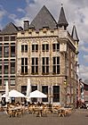
Medieval architecture in Aachen
-
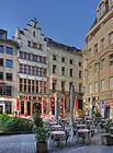
Cölner Hofbräu Früh in Cologne
-
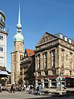
Reinoldikirche and Alter Markt in Dortmund
-
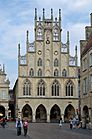
Historical City Hall in Münster
-
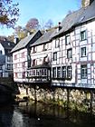
Timber framing in Monschau
-
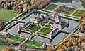
Schloss Nordkirchen
.jpg)
.jpg)


.jpg)
Modern Architecture
-
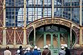
Art Nouveau Zeche Zollern in Dortmund
-
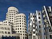
Neuer Zollhof in Düsseldorf
-
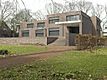
Haus Lange and Haus Esters in Krefeld
-
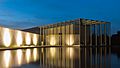
Langen Foundation in Neuss
-
Schwebebahn in Wuppertal
-
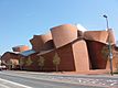
MARTa Herford


World Heritage Sites
North Rhine-Westphalia is home to several World Heritage Sites, which are places recognized for their global importance. These include:
- Aachen Cathedral in Aachen
- Cologne Cathedral in Cologne
- The Zollverein Coal Mine in Essen
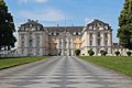
- The Augustusburg Palace in Brühl
- The Imperial Abbey of Corvey in Höxter
-
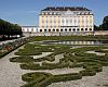
Augustusburg and Falkenlust
-
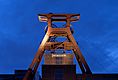
Zollverein Coal Mine
-

Imperial Abbey of Corvey


Delicious Local Food
| Black Forest Ham (Schwarzwälder Schinken) is a famous German ham. It comes from the Black Forest region, known for its meat production. This ham has a special way of being cured and smoked. It's usually served cold, often as part of a breakfast or lunch platter. | |
| Maultaschen are like dough "pockets" filled with ground meat or spinach. They are similar to Italian ravioli. This dish is often eaten for dinner in North Rhine-Westphalia, especially during holidays. Its history goes back to the 17th century, when Italian missionaries shared their culture. | |
| Pumpernickel bread is one of Germany's most famous breads. It's made from dark rye and has a unique, slightly sweet taste. This bread has been baked for centuries. Its name became popular during wartime, when bread was rationed. |


Images for kids
-
ThyssenKrupp headquarters in Essen
-
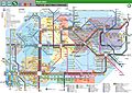
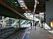
Transportsystem Rhein-Ruhr in 2014
-
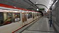
Stadtbahn in Dortmund
-
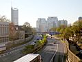
Autobahn A40 in Essen
-
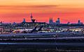
Airport in front of Cologne's skyline
-
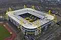
Signal Iduna Park, the stadium of Bundesliga club Borussia Dortmund, is the largest stadium in Germany.
-
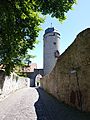
Gate and Tower of the medieval town-fortification in Warburg
-
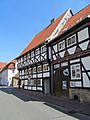
Eckmaenneken-House in Warburg; eldest-dated timber-framed-house of Westphalia
-
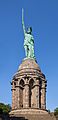
Hermann's Monument nearby Detmold
-
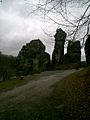
Externsteine
-
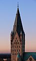
Paderborn Cathedral
-
Augustusburg and Falkenlust
.jpg)


See also
 In Spanish: Renania del Norte-Westfalia para niños
