
Siegen facts for kids
Quick facts for kids
Siegen
|
|||
|---|---|---|---|

Upper town
|
|||
|
|||
| Country | Germany | ||
| State | North Rhine-Westphalia | ||
| Admin. region | Arnsberg | ||
| District | Siegen-Wittgenstein | ||
| Elevation | 290 m (950 ft) | ||
| Population
(2022-12-31)
|
|||
| • Total | 102,560 | ||
| Time zone | CET/CEST (UTC+1/+2) | ||
| Postal codes |
57072–57080
|
||
| Dialling codes | 0271 | ||
| Vehicle registration | SI | ||
| Website | www.siegen.de | ||


Siegen (German pronunciation: [ˈziːɡn̩]) is a city in Germany. It is located in the southern part of North Rhine-Westphalia.
Siegen is the main city in the Siegen-Wittgenstein district. It is also a university town, with almost 20,000 students. In 1975, Siegen grew larger and its population went over 100,000 people.
Contents
Geography of Siegen
Where is Siegen located?
The city of Siegen sits in a valley near the Sieg river. Many smaller valleys branch out from here. The hills around the city are covered in forests. To the north is the Sauerland area. To the northwest is the Rothaargebirge mountain range. The Westerwald area is to the southwest.
Siegen is about 83 km (52 mi) north of Hagen. It is about 125 km (78 mi) southeast of Frankfurt am Main. Koblenz is about 105 km (65 mi) to the southwest. Cologne is about 93 km (58 mi) to the west.
The city is part of the Orange Route. This is a special holiday road in Germany and the Netherlands. It connects places linked to the House of Orange.
How big is Siegen?

Siegen covers about 115 km2 (44 sq mi) of land. It is about 12 km (7 mi) wide from east to west. It is also about 12 km (7 mi) long from north to south. The city's edge is 48 km (30 mi) long.
Siegen is about 290 m (951 ft) above sea level. The highest point is Pfannenberg peak, at 499 m (1,637 ft). The lowest point is in Niederschelden, at 215 m (705 ft). About 60% of Siegen is covered in woods. This makes it one of Germany's greenest cities.
The city is divided into six main areas called Bezirke, which are like boroughs. These boroughs are then split into smaller communities. Each borough has a special board that helps make decisions for its area.
Siegen's main areas
Siegen has six main boroughs and their communities:
- District I (Geisweid): Birlenbach, Meiswinkel, Langenholdinghausen, Geisweid, Dillnhütten, Sohlbach, Buchen, Niedersetzen, Obersetzen
- District II (Weidenau)
- District III (Ost): Kaan-Marienborn, parts of Alt-Siegen (Giersberg), Bürbach, Volnsberg, Breitenbach, Feuersbach
- District IV (Mitte): Alt-Siegen (other parts)
- District V (West): Seelbach, Trupbach and parts of Alt-Siegen (Wellersberg, Fischbacherberg, Achenbach, Rothenberg)
- District VI (Süd): Oberschelden, Gosenbach, Niederschelden, Eiserfeld, Eisern
Some neighborhoods are also known by names like Unterstadt or Oberstadt. These are not official areas but help people find their way around.
Neighboring towns
Siegen shares borders with several towns and communities:
- North: Kreuztal and Wenden
- East: Netphen
- Southeast: Wilnsdorf
- South: Neunkirchen
- West: Mudersbach (in Rhineland-Palatinate)
- Northwest: Freudenberg
History of Siegen
The name Siegen comes from the river Sieg. The first time Siegen was mentioned in writing was in 1079. Mining has been very important to the city's history for a long time. There are many old mines within the city.
In 1224, Siegen was called a new town. It was owned by two rulers, the Count of Nassau and the Archbishop of Cologne. In 1303, Siegen got its own town rights. By 1381, the town was fully owned by the Nassau family.
In the 1500s, Siegen was a strong, walled town. It had 16 towers and three gates. There was also a large castle. The town had big fires in 1592 and 1695.
In 1536, a school was built in an old monastery. This school later became a Gymnasium, which is a type of high school. In 1616, a military school was founded.
The city's rulers changed between Catholic and Protestant over the years. This led to some disagreements. In 1707, one ruler, Wilhelm Hyacinth, was forced to leave the town. In 1734, the Protestant rulers died out. The area then came under the control of the Prince of Orange and the Prince of Nassau-Diez. Under their rule, mining and farming grew.
After Napoleon's time, Siegen became part of the Kingdom of Prussia in 1815. It grew into an important center in South Westphalia. In 1923, Siegen became a separate city, but it still remained the main city for its district. In 1975, Siegen joined with other towns, and its population grew. It also became part of the new Siegen-Wittgenstein district.
During World War II, Siegen was bombed because it was an important railway hub. The city saw fighting in April 1945 before the war ended.
Religion in Siegen


Siegen was first part of the Archbishopric of Mainz. In 1530, the Reformation came to Siegen. The town became mostly Protestant. Later, some people became Catholic again.
Today, Siegen has many different churches. There are Roman Catholic, Greek Orthodox, and Romanian Orthodox churches. Many other Christian churches, like Baptists and Methodists, are also in Siegen.
Because many people from Turkey and Arab countries live in Siegen, there are also several mosques. More than 15,000 Muslims live in Siegen.
City growth
Siegen has grown by joining with other communities over time:
- 1902 and 1912: parts of Buschgotthardshütten
- 1934: parts of Achenbach
- 1937: parts of Achenbach and Buschgotthardshütten
- 1966: Trupbach, Seelbach, Breitenbach, Bürbach, Kaan-Marienborn and Volnsberg
- 1969: Feuersbach
- 1974: towns of Hüttental and Eiserfeld
Population changes

In 1897, Siegen had 20,000 people. By 1939, it had 40,000. During World War II, the city lost about 30% of its people. By 1945, only 28,000 people lived there. The population returned to its pre-war size by 1952.
On January 1, 1975, Siegen's population went over 100,000. This happened when it joined with Hüttental and Eiserfeld. At one point, it had 117,224 people, its highest number ever. By 2005, the population was 105,328.
Places to see in Siegen


Even though much of Siegen was destroyed in World War II, many interesting buildings remain. These include two stately homes: the Oberes Schloss (Upper Stately Home) and the Unteres Schloss (Lower Stately Home).
Oberes Schloss (Upper Stately Home)
This castle on the Siegberg hill was first mentioned in 1259. It was once the home of the Nassau family. Since 1905, it has been the Siegerland Museum. Here you can see local exhibits and many paintings. The most famous paintings are by Peter Paul Rubens, who was born in Siegen. There are also portraits of the Nassau and Orange families. The top floor shows how homes looked in the 1800s.
Unteres Schloss (Lower Stately Home)
The Lower Stately Home was built in its current shape in the late 1600s. The Protestant branch of the Nassau-Siegen family lived here. Part of the Schloss is the "Fat Tower" (Dicker Turm) with a carillon (a musical instrument with bells). In 1959, a memorial was built here for victims of war. The crypt (underground vault) of the Nassau princely family is also inside.
Today, the Schloss is used for government offices. There are plans for a university to move into the Unteres Schloss in the future.
Churches to visit
Two important churches in downtown Siegen are the Martinikirche (from the 11th century) and the Nikolaikirche. The Nikolaikirche has a unique eight-sided shape and a golden "coronet" (Krönchen) on its tower. This coronet is a symbol of the city, and Siegen is sometimes called Krönchenstadt (Coronet City). Another church is the Marienkirche, built by Jesuits between 1702 and 1729. Siegen's Old Town and several museums are also worth seeing.
Gasometer

In the southwest of the city center, there is a round gasometer that is protected as a historical monument. It is one of the oldest round gas holders still standing. It's special because its outer shell is riveted together. Only three other such gas holders exist in Germany. This gasometer was moved a few meters for road construction. Now, it is part of a model of the planets, representing the sun.
Cemeteries
Siegen has 36 city-run cemeteries. Ten of these are no longer used for new burials. The cemeteries cover a large area and have about 65,000 graves. Many cemeteries in the region are on hillsides and look like green parks.
Some cemeteries in Siegen are:
- Lindenbergfriedhof
- Hermelsbacher Friedhof
- Stockfriedhof
- Geisweider Friedhof
- Haardter Friedhof
- Gilbergfriedhof
- Friedhof Kaan-Marienborn
- Neuer Friedhof Niederschelden
Culture in Siegen
Theatre and shows

Siegen has the Apollo-Theater, which opened in 2007. It was once a cinema and is now an important new theatre.
Since 1992, the Lÿz cultural center has hosted many shows. These include cabaret, music, and theatre. About 150 events happen there each season.
Larger events take place at the Bühne der Stadt (City's Stage), the Siegerlandhalle, or the Bismarckhalle. There are also outdoor concerts and shows at the Unteres Schloss.
Music groups
- Philharmonie Südwestfalen (South Westphalia Orchestra)
- Evangelische Kantorei Siegen (Evangelical Choir Siegen)
- Bach-Chor Siegen (Bach Choir Siegen)
- Sängerkreis Siegerland (Siegerland Singers' Circle)
Museums
The main art centers in Siegen are the Museum for Contemporary Art and the Haus Seel – city gallery.
The Siegerland Museum focuses on the history of the region. The Oranienstraße House, built in 1900, is part of the Siegerland Museum. It hosts many different temporary exhibitions, from old archaeological finds to modern art. They also have readings by poets and authors, and classical music concerts.
In Geisweid, you can find the Beatles Home Museum. It is run by Harold Krämer. According to the 2000 Guinness Book of Records, it is the smallest public museum in the world about The Beatles. It has over 17,000 items, including recordings, souvenirs, and autographs.
Events in Siegen
- Early in the year: SILA (Siegerland Exhibition), every two years
- March to November, first Saturday of each month: Flea market in Siegen-Geisweid (no new goods)
- June to August: "Mittwochs in" (Wednesdays in) – different bands play every Wednesday in Siegen-Weidenau
- June: Johannimarkt, a fair that has been held for about 400 years
- June/July: Siegener Sommerfestival (Siegen Summer Festival) – plays, cabaret, theatre, music, and movies
- July: Stadtfest (City Festival), every two years
- July: Rubensfest, every two years
- August: Siegen Open-Air Cinema
- August: Christopher Street Day (CSD), since 2000
- August: Siegtal-Pur – all streets are open only for bikes, even the local highway
- Summer: Street Festival at the Corn Market
- October: 2nd Sunday: Bürgerfest Geisweid (Geisweid Citizens' Festival)
- November: Geisweider Adventsmarkt (Geisweid Advent Market)
- December: Christmas market
Local language
People in Siegen and the surrounding area sometimes speak a special local dialect called Siegerländisch, in addition to standard German.
Local stories
The Dilldappe is an old mythical creature from the Siegerland. It is said to live in the local forests. In the 1980s, a writer and cartoonist named Matthias Kringe made a calendar about this creature, written in the local dialect.
Rubens Prize of Siegen
The Rubens Prize is given by the City of Siegen every five years. It honors a painter or graphic artist whose work has been very important in Europe. The prize is named after Peter Paul Rubens, a famous painter born in Siegen. He was known for his European art and diplomatic work.
Past winners include:
- Hans Hartung (1957/1958)
- Giorgio Morandi (1962)
- Francis Bacon (1967)
- Antoni Tàpies (1972)
- Fritz Winter (1977)
- Emil Schumacher (1982)
- Cy Twombly (1987)
- Rupprecht Geiger (1992)
- Lucian Freud (1997)
- Maria Lassnig (2002)
- Sigmar Polke (2007)
- Bridget Riley (2012)
- Niele Toroni (2017)
Sports in Siegen
Siegen has 160 sports clubs with about 37,000 members. The Sportfreunde Siegen men's football team played in the 2nd Bundesliga in 2005, which is a high level of German football. The TSV Siegen women's football team was very successful in the 1990s, winning the German Championship six times.
Getting around Siegen
Air travel
The Siegerland Airport is located south of the city in Burbach. It is mainly used for private planes and parachuting. There are no regular flights to other German cities.
Biking in Siegen
Siegen is on the European long-distance path E1. This path goes from Sweden to Italy. However, Siegen does not have a well-developed network of bike paths. It can be challenging to bike in the city due to the many hills and roads designed for cars.
Train travel


Siegen station is an important train hub. Several train lines meet here:
- The Ruhr–Sieg line connects Siegen to other cities.
- The Rothaar Railway connects to areas like Erndtebrück.
- The Dill Railway connects to places like Dillenburg.
- The Sieg line connects to areas like Au.
Trains usually run every hour or two hours on these lines.
Bus travel
On March 18, 1895, the world's first bus line using a petrol-powered bus started in this area. It ran from Netphen to Siegen. Today, Siegen has many local, express, and night buses. These buses connect Siegen to its communities and nearby towns. They are run by the South Westphalia Transport Services (VWS).
Roads
Siegen is connected to major highways like A 45 (Dortmund – Aschaffenburg) and A 4 (Cologne – Olpe). It also has federal highways 54, 54n, 62, and 62n.
Siegen is home to the Siegtalbrücke, one of the highest bridges in Germany. It is about 96 metres (315 ft) high and 1,050 metres (3,440 ft) long. It was built between 1964 and 1969.

The Hüttentalstraße (HTS) is like a city highway that runs through Siegen. It is mostly elevated above the ground.
A new part of the A 4 highway was opened in 2007. It includes eight valley bridges and many underpasses and overpasses.
Economy of Siegen

Siegen is a center for services and administration in South Westphalia. A lot of its industry is based on metalworking.
Siegen has many places to shop. There are pedestrian areas in Bahnhofsstraße and Kölner Tor. There are also large shopping centers like City-Galerie (opened 1998) and Sieg Carré (opened 2006). In 2005, an IKEA store opened in Siegen.
Public services
Siegen is where the Siegen-Wittgenstein district government is located. It also has a Chamber of Industry and Trade, which helps businesses in the region.
The city is an important legal center. It has a State Court, a local court, and a labor court.
Media in Siegen
The Westdeutscher Rundfunk (WDR) has a studio in Siegen. They produce local radio and TV news for South Westphalia. The Siegener Zeitung is a daily newspaper in Siegen. Local editions of the Westfälische Rundschau and Westfalenpost are also published here. Radio Siegen is a local radio station.
Education in Siegen
In the early 1600s, the Herborn Academy was temporarily moved to Siegen.
Siegen's oldest school is the Gymnasium am Löhrtor.
High schools (Gymnasiums)
- Gymnasium am Löhrtor (GAL)
- Fürst-Johann-Moritz-Gymnasium (FJM)
- Peter-Paul-Rubens-Gymnasium
- Evangelisches Gymnasium (EV)
- Gymnasium auf der Morgenröthe (GAM)
Primary schools
- Albert Schweitzer Schule
- Birlenbacher Schule
- Burgschule
- Diesterwegschule
- Dreisbachschule
- Eiserner Schule
- Fischbacherbergschule
- Friedrich Flender Schule
- Geisweider Schule
- Giersbergschule
- Glückaufschule
- Gosenbacher Schule
- Grundschule Eiserfeld
- Grundschule Kaan-Marienborn
- Hammerhütter Schule
- Hüttentalschule
- Jung Stilling Schule
- Lindenbergschule
- Nordschule
- Obenstruthschule
- Sonnenhangschule
- Spandauer Schule
Universities and colleges
Siegen is home to the University of Siegen. It was founded on August 1, 1972.
The Fachhochschule für Oekonomie & Management also has a study center in Siegen.
Siegen also has various other schools for general education and professional training.
Twin towns – sister cities
Siegen is twinned with these cities:
 Spandau (Berlin), Germany (1952)
 Katwijk, Netherlands (1963)
 Leeds, England, United Kingdom (1966)
 Emek Hefer regional council, Israel (1973)
 Ypres, Belgium (1967)
 Zakopane, Poland (1989)
- Plauen, Germany (1990)
Notable people from Siegen
- Henry III of Nassau-Breda (1483–1538), Count of Nassau
- Tilemann Stella (1525–1589), scholar and cartographer
- John VII ‘the Middle’ of Nassau-Siegen (1561–1623), military expert
- Peter Paul Rubens (1577–1640), famous Baroque painter
- Adolph Diesterweg (1790–1866), educator
- Fritz Busch (1890–1951), conductor
- Adolf Busch (1891–1952), violinist and conductor
- Walter Kraemer (1892–1941), politician and resistance fighter
- Heinrich Gontermann (1896–1917), fighter pilot
- Walter Schneider (1927–2010), motorcycle racer
- Bernd Becher (1931–2007), artist and photographer
- Joachim Frank (born 1940), biophysicist and Nobel laureate
- Rolf Stommelen (1943–1983), Formula One racer
- Josef Clemens (born 1947), bishop
- Reinhard Goebel (born 1952), conductor and violinist
- Annegret Kober (born 1957), swimmer
- Bernward Koch (born 1957), musician
- Burkhard Jung (born 1958), Lord Mayor of Leipzig
- Dieter Falk (born 1959), music producer
- Peter Autschbach (born 1961), guitarist
- Navid Kermani (born 1967), scholar and writer
- Sabrina Mockenhaupt (born 1980), long distance runner
- August Wittgenstein (born 1981), prince and actor
- Florian Kringe (born 1982), footballer
- Moritz Volz (born 1983), footballer
- Christian Nüchtern (born 1992), ice dancer
- Andromache (born 1995), Greek singer
Honorary citizens
Siegen has given honorary citizenship to these people:
- 1887: Heinrich von Achenbach, High President
- 1891: Otto von Bismarck, German Chancellor
- 1933: Paul von Hindenburg, General Field Marshal and President
- 1953: Alfred Fißmer, former Mayor
Images for kids
-
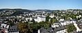
A view over Siegen with the university in the background
See also
 In Spanish: Siegen para niños
