
Rhineland-Palatinate facts for kids
Quick facts for kids
Rhineland-Palatinate
Rheinland-Pfalz
|
|||
|---|---|---|---|
|
|||

Position of the Rhineland-Palatinate within Germany
|
|||
| Country | Germany | ||
| Capital | Mainz | ||
| Area | |||
| • Total | 19,854.21 km2 (7,665.75 sq mi) | ||
| Population
(31 December 2016)
|
|||
| • Total | 4,073,280 | ||
| • Density | 205.15951/km2 (531.3607/sq mi) | ||
| Time zone | UTC+1 (CET) | ||
| • Summer (DST) | UTC+2 (CEST) | ||
| Website | rlp.de | ||


Rhineland-Palatinate (German: Rheinland-Pfalz) is one of the 16 states in Germany. It covers an area of about 19,854 square kilometers (7,666 square miles). Around 4.073 million people live there. The capital city of Rhineland-Palatinate is Mainz.
Contents
A Look at History
Rhineland-Palatinate was created on 30 August 1947. It was formed after World War II. Different parts of Germany were put together to make this new state. These parts included areas that used to belong to Bavaria and Prussia.
The people living in these areas had a special vote. This vote, called a referendum, happened on 18 May 1947. They voted to agree with the new borders and the creation of their state.
Exploring the Geography
Rhineland-Palatinate shares borders with several other places. To the north, it borders North Rhine-Westphalia. To the east, you'll find Hesse and Baden-Württemberg. To the south, it borders France. To the west, it touches Saarland, Luxembourg, and Belgium.
Rivers and Mountains
The most important river in the state is the Rhine river. It forms part of the border with Baden-Württemberg and Hesse. Then, it flows through the northern part of Rhineland-Palatinate. The Rhine Valley is surrounded by mountains. Many important historical places in Germany are found here.
In the northwest, you can find the southern parts of the Eifel mountains. Further south is the Hunsrück mountain range. On the other side of the Rhine, the Taunus mountains continue this hilly landscape. The southern part of the state has hilly lands called the Palatine Forest (Pfälzerwald).
Smaller rivers flow into the Rhine. These are called tributaries. The main ones are the Moselle (Mosel), the Lahn, and the Nahe. They separate the different mountain areas.
How the Government Works
Rhineland-Palatinate is a parliamentary democracy. This means that people vote for their leaders. Every five years, all Germans over 18 years old vote for members of the state parliament. This parliament is called the German: Landtag.
The parliament then chooses the leader of the state. This leader is called the Minister President. The parliament also approves the other government officials, known as cabinet members. Interestingly, Rhineland-Palatinate is the only German state that has a special cabinet minister just for winegrowing!
Amazing Castles to See
Rhineland-Palatinate is famous for its many old castles. Here are a few examples:


Many other castles are found throughout the state. Some of them include:
| Name | Place |
|---|---|
| Burg Arras | Alf |
| Alte Burg | Boppard |
| Reichsburg Cochem | Cochem |
| Dahn | Dahn |
| Festung Ehrenbreitstein | Koblenz, Ehrenbreitstein district |
| Ehrenburg | Brodenbach |
| Burg Eltz | Münstermaifeld |
| Burg Falkenstein | Falkenstein |
| Frauenburg | Frauenberg |
| Hambacher Schloss | Neustadt an der Weinstraße, Hambach district |
| Burg Hohenfels | Imsbach |
| Burg und Schloss Idar-Oberstein | Idar-Oberstein |
| Burg Lahneck | Lahnstein |
| Burg Altleiningen | Altleiningen |
| Marksburg | Braubach |
| Burg Nassau | Nassau |
| Nürburg | Nürburg |
| Burg Olbrück | Niederdürenbach |
| Burg Pfalzgrafenstein | on an island in the Rhine, by Kaub |
| Burg Reichenstein | Trechtingshausen |
| Burg Rheinfels | Sankt Goar |
| Rheinstein | Trechtingshausen |
| Schloss und Burg Sayn | Bendorf |
| Schloss Bürresheim | Sankt Johann, Mayen-Koblenz, Bürresheim district |
| Schloss Neuwied | Neuwied |
| Schloss Stolzenfels | Koblenz, Stolzenfels district |
| Schmidtburg | Schneppenbach |
| Schönburg | Oberwesel |
| Burg Sooneck | Niederheimbach |
| Burg Stahleck | Bacharach |
| Trifels | Annweiler am Trifels |
| Schloss Montabaur | Montabaur |
| Thurant | Alken |
Universities and Colleges
Rhineland-Palatinate has many places for higher education. There are 7 universities and 13 "Fachhochschulen" (colleges of applied sciences).
Some of the main universities include:
- Technische Universität Kaiserslautern
- Universität Koblenz-Landau (with campuses in Koblenz and Landau)
- Johannes Gutenberg-Universität Mainz
- Universität Trier

Political Leaders Over Time
The Ministers President are the heads of government for Rhineland-Palatinate. Here are the people who have held this important role since 1947:
- 1947–1947: Wilhelm Boden, from the CDU party
- 1947–1969: Peter Altmeier, CDU
- 1969–1976: Helmut Kohl, CDU
- 1976–1988: Bernhard Vogel, CDU
- 1988–1991: Carl-Ludwig Wagner, CDU
- 1991–1994: Rudolf Scharping, from the SPD party
- 1994–2013: Kurt Beck, SPD
- 2013–present: Malu Dreyer, SPD
International Partnerships
Rhineland-Palatinate has special partnerships with regions and countries around the world. These partnerships help build friendships and cooperation. Some of these partners include:
 France, the Bourgogne region
 Rwanda, a country in East Africa
 Spain, the Province of València
 Belgium's German-Speaking Community
 Poland, the Voivodeship of Oppeln
 Czech Republic, Middle Bohemia
 China, the Province of Fujian
 USA, the State of South Carolina
 Japan, the Prefecture of Iwate
How the State is Organized
Rhineland-Palatinate is divided into 24 smaller areas called districts. These districts are grouped into three larger administrative regions: Koblenz, Trier, and Rheinhessen-Pfalz.
Districts of Rhineland-Palatinate
Each district has a special code for car license plates.

- Ahrweiler (AW)
- Altenkirchen (AK)
- Alzey-Worms (AZ)
- Bad Dürkheim (DÜW)
- Bad Kreuznach (KH)
- Bernkastel-Wittlich (WIL)
- Birkenfeld (BIR)
- Cochem-Zell (COC)
- Donnersbergkreis (KIB)
- Eifelkreis Bitburg-Prüm (BIT)
- Germersheim (GER)
- Kaiserslautern (KL)
- Kusel (KUS)
- Mainz-Bingen (MZ)
- Mayen-Koblenz (MYK)
- Neuwied (NR)
- Rhein-Hunsrück-Kreis (SIM)
- Rhein-Lahn-Kreis (EMS)
- Rhein-Pfalz-Kreis (formerly LU, now RP)
- Südliche Weinstraße (SÜW)
- Südwestpfalz (PS)
- Trier-Saarburg (TR)
- Landkreis Vulkaneifel (DAU)
- Westerwaldkreis (WW)
Major Cities
Here are some of the biggest cities in Rhineland-Palatinate:
Related pages
Images for kids
-
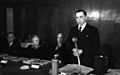
Minister-president Peter Altmeier at the Rittersturz Conference in 1948
-
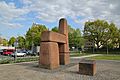
The Peter Altmeier Monument in Koblenz


See also
 In Spanish: Renania-Palatinado para niños
