
Burgundy facts for kids
Quick facts for kids
Burgundy
Bourgogne
|
|||
|---|---|---|---|
|
|||
 |
|||
| Country | |||
| Dissolved | 2016-01-01 | ||
| Prefecture | Dijon | ||
| Departments | |||
| Area | |||
| • Total | 31,582 km2 (12,194 sq mi) | ||
| Population
(2008-01-01)
|
|||
| • Total | 1,631,000 | ||
| • Density | 51.643/km2 (133.76/sq mi) | ||
| Time zone | UTC+01:00 (CET) | ||
| • Summer (DST) | UTC+02:00 (CEST) | ||
| ISO 3166 code | FR-D | ||
| GDP (2012) | Ranked 16th | ||
| Total | €42.7 billion (US$55.0 bn) | ||
| Per capita | €25,996 (US$33,436) | ||
| NUTS Region | FR2 | ||
| Website | cr-bourgogne.fr | ||


Burgundy (which is Bourgogne in French) was once an important administrative area in France. Today, it is part of a larger region called Bourgogne-Franche-Comté. It is also a historic area in eastern France. People from Burgundy are called Bourguignon.
Burgundy is a large region, covering over 31,500 square kilometres (12,200 sq mi). This means it makes up about 6% of France's total land.
The region was made up of four main areas called departments. These were Côte-d'Or, Nièvre, Saône-et-Loire, and Yonne. The main city and capital of Burgundy was Dijon.
Contents
Burgundy's Past: A Look at Its History
Burgundy got its name from the Burgundian tribe. These Germanic people moved there from an island in the Baltic Sea. They arrived when the Roman Empire was falling apart. They wanted to create their own kingdom with its own rules. This kingdom even included parts of what is now Switzerland.
Powerful Dukes of the Middle Ages
During the Middle Ages, powerful rulers called dukes governed Burgundy. In the 15th century, Burgundy was very strong. Its dukes controlled lands that stretched far north, even into the Netherlands.
However, things changed after Duke Charles the Bold died. He was trying to conquer the city of Nancy in 1477. After his death, France took control of southern Burgundy. It became a province of France until 1790. The northern parts of Burgundy went to the House of Habsburg. These lands later became known as the Southern Netherlands.
Exploring Burgundy's Geography
.svg)
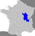
The Burgundy region is one of the biggest areas in Metropolitan France. It covers about 31,582 km2 (12,194 sq mi). It shares borders with five other French regions. These are Champagne-Ardenne to the north and Franche-Comté to the east. To the southeast is Rhône-Alpes, and to the southwest is Auvergne. Finally, Centre-Val de Loire is to the west, and Île-de-France is to the northwest.
 |
Île-de-France | Champagne-Ardenne | |
|
| Centre-Val de Loire | Franche-Comté | |||
| Auvergne | Rhône-Alpes |
Most of Burgundy is a plateau, which is a flat area of land that is higher than the land around it. This plateau has many low hills, often called the Burgundy Hills. These hills are surrounded by the valleys of the region's main rivers. The Yonne river and its smaller rivers (called tributaries) flow in the north. To the southeast, you'll find the valley of the Saône river.
Mountains and Rivers of Burgundy
In the middle of the plateau, there's a group of low mountains called the Morvan. The highest point in Burgundy is found here. It's called the Haut-Folin (46°59′46″N 4°02′13″E / 46.99611°N 4.03694°E). This peak is in the Saône-et-Loire department and stands 901 m (2,956 ft) tall.
The most important rivers in Burgundy are the Yonne, Armançon, Loire, Seine, and Saône.
Burgundy has an oceanic climate. This means it has mild summers. It's known as a "Marine West Coast Climate" in the Köppen climate classification.
Departments: How Burgundy Was Divided
The Burgundy region was made up of four main areas called departments. Each department has its own main city, called a prefecture.
| Department | Main City (Prefecture) | Population (2012) |
Area (km²) |
|---|---|---|---|
| Côte-d'Or | Dijon | 527,403 | 8,763 |
| Nièvre | Nevers | 216,786 | 6,817 |
| Saône-et-Loire | Mâcon | 555,039 | 8,575 |
| Yonne | Auxerre | 341,902 | 7,427 |
People and Cities of Burgundy
In 2012, the Burgundy region had about 1,641,130 people living there. This means there were about 52.0 people per square kilometer.

Here are the ten largest cities in the region:
| City | Population (2012) |
Department |
|---|---|---|
| Dijon | 152,071 | Côte-d'Or |
| Chalon-sur-Saône | 44,564 | Saône-et-Loire |
| Nevers | 35,327 | Nièvre |
| Auxerre | 35,096 | Yonne |
| Mâcon | 32,917 | Saône-et-Loire |
| Sens | 25,106 | Yonne |
| Le Creusot | 22,574 | Saône-et-Loire |
| Beaune | 21,806 | Côte-d'Or |
| Montceau-les-Mines | 18,956 | Saône-et-Loire |
| Autun | 14,124 | Saône-et-Loire |
Burgundy's Economy: Famous Wines
Burgundy is very famous for its wines. Both red and white wines are made here. Many well-known wines, like Macon and Beaujolais, were first created in this region. There are also some special "Arbois"-type wines. These wines are a unique color, somewhere between red and white, almost yellow.
Gallery
-
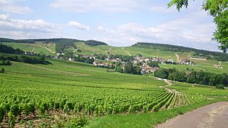
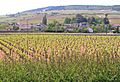
Vineyards at Mercurey.
-
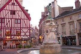
Place du Bareuzai, Dijon.
-
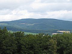
Haut-Folin - View from Mont Beuvray
-
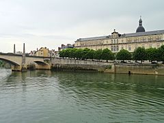
View of Saône River in Chalon sur Saône, Saône-et-Loire.
-
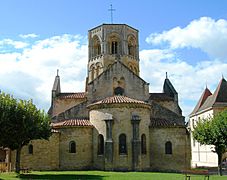
Church in Semur-en-Brionnais, Saône-et-Loire.
-
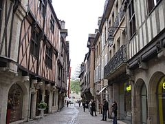
Verrerie Street, Dijon.


Images for kids
-
Map of France showing Burgundy and provincial boundaries in 1789
-
Chardonnay vineyards in the south of Côte de Beaune surrounding the town of Meursault
-
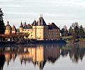
Château de La Clayette
-
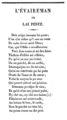
Poem in Burgundian dialect


See also
 In Spanish: Borgoña para niños
