
Côte-d'Or facts for kids
Quick facts for kids
Côte-d'Or
|
|||
|---|---|---|---|

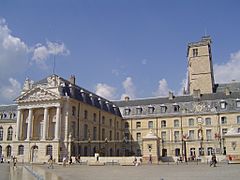
Prefecture building of the Côte-d'Or department, in Dijon
|
|||
|
|||

Location of Côte-d’Or in France
|
|||
| Country | France | ||
| Region | Bourgogne-Franche-Comté | ||
| Département | 4 March 1790 | ||
| Prefecture | Dijon | ||
| Subprefectures | Beaune, Montbard | ||
| Area | |||
| • Total | 8,763.2 km2 (3,383.5 sq mi) | ||
| Population
(2014)
|
|||
| • Total | 531,380 | ||
| • Density | 60.6377/km2 (157.0508/sq mi) | ||
| Demonym(s) | Côte-d'oriens, Costaloriens | ||
| Time zone | UTC+1 (CET) | ||
| • Summer (DST) | UTC+2 (CEST) | ||
| ISO 3166 code | FR-21 | ||
| Arrondissements | 3 | ||
| Cantons | 23 | ||
| Communes | 704 | ||
| Website | http://www.cotedor.fr | ||


Côte-d'Or is a special area in eastern France. Its name means "Golden Slope," which sounds pretty cool! It's one of the first 83 departments (like a state or county) created during the French Revolution. Côte-d'Or is also one of the eight departments in the Bourgogne-Franche-Comté region.
The main city and capital of Côte-d'Or is Dijon. People who live here are called Costaloriens or Côte-d'Oriens.
Contents
History of Côte-d'Or
Côte-d'Or was one of the first 83 departments made in France. This happened during the French Revolution on March 4, 1790. It was created from a part of the old area called Burgundy.
At first, Côte-d'Or was split into seven smaller areas called districts. Later, in 1800, these districts were changed into four larger areas called arrondissements. After a big battle called the Battle of Waterloo in 1815, the department was taken over by the Austrian army for a few years. In 1926, some of the arrondissements were combined to form a new one called Montbard.
Why is it Called Côte-d'Or?

Côte-d'Or is unique because it's the only French department not named after a river or a mountain. The name was chosen by Charles-André-Rémy Arnoult. He thought of the name because of the beautiful golden color the vineyards in the region turn in the autumn.
The French word côte here means a "slope" or a "hillside." So, "Golden Slope" describes the golden hillsides of the vineyards.
Geography of Côte-d'Or
Côte-d'Or is located in the Bourgogne-Franche-Comté region of France. It shares its borders with seven other departments.
- To the North: Aube (in the Grand Est region)
- To the Northeast: Haute-Marne (in the Grand Est region)
- To the East: Haute-Saône (in the Bourgogne-Franche-Comté region)
- To the Southeast: Jura (in the Bourgogne-Franche-Comté region)
- To the South: Saône-et-Loire (in the Bourgogne-Franche-Comté region)
- To the Southwest: Nièvre (in the Bourgogne-Franche-Comté region)
- To the West: Yonne (in the Bourgogne-Franche-Comté region)

The department covers an area of about 8,763 square kilometers (3,383 square miles). The highest point is Mont de Gien, which is 721 meters (2,365 feet) high. The lowest point is 174 meters (571 feet) high, where the Saône river leaves the department.
A line of hills called the Plateau de Langres runs through the department. This plateau continues as the Côte d'Or escarpment. The famous Burgundy vineyards are found on the slopes of this escarpment. To the southeast, the land is flatter, in the wide valley of the Saône river.
Rivers in Côte-d'Or
Many important rivers flow through Côte-d'Or:
- The Seine river starts here, in the southern part of the Plateau de Langres.
- The Saône river is a big river that flows into the Rhône. Several smaller rivers like the Vingeanne, Tille, Bèze, and Ouche join the Saône.
- The Arroux river flows into the Loire.
Climate in Côte-d'Or
The climate in Dijon is called an "Oceanic climate." This means it has mild temperatures. The average temperature for the year in Dijon is about 10.6°C (51.1°F). July is usually the warmest month, with an average of 19.4°C (66.9°F). January is the coolest, with an average of 1.7°C (35.1°F).
Dijon gets about 698.5 mm (27.5 inches) of rain each year. October is the rainiest month, and February is the driest. In the higher areas like the Plateau de Langres, winters are long and cold, with lots of frosts.
How Côte-d'Or is Governed
The department is managed by the Departmental Council of Côte-d'Or, which is located in Dijon. Côte-d'Or is part of the Bourgogne-Franche-Comté region.
Administrative Areas
Côte-d'Or is divided into:
- 3 arrondissements (districts)
- 23 cantons (smaller administrative areas)
- 704 communes (towns or villages)
Here's a quick look at the main arrondissements:
| Arrondissement | Capital | Population (2014) |
Area (km²) |
Communes |
|---|---|---|---|---|
| Beaune | Beaune | 97,107 | 2,118.3 | 223 |
| Dijon | Dijon | 373,574 | 3,049.0 | 228 |
| Montbard | Montbard | 60,699 | 3,595.9 | 253 |
Population of Côte-d'Or
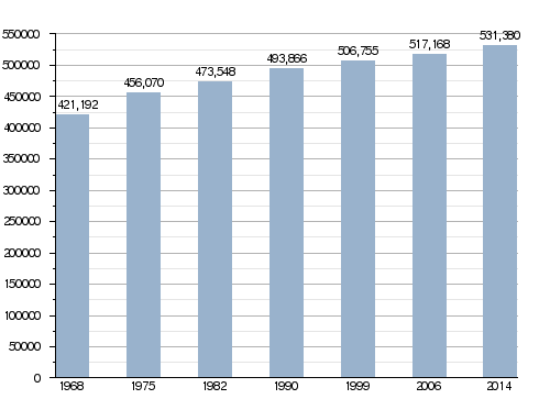
In 2014, Côte-d'Or had a population of 531,380 people. This means there were about 60.6 people living in each square kilometer. The arrondissement of Dijon has the most people, with 373,574 residents. Beaune has 97,107 people, and Montbard has 60,699.
How the population of Côte-d'Or has changed over time
Here are some of the biggest cities in Côte-d'Or:
| City | Population (2014) |
Arrondissement |
|---|---|---|
| Dijon | 153,668 | Dijon |
| Beaune | 21,579 | Beaune |
| Chenôve | 14,165 | Dijon |
| Talant | 11,346 | Dijon |
| Chevigny-Saint-Sauveur | 11,097 | Dijon |
| Quetigny | 9,675 | Dijon |
| Fontaine-lès-Dijon | 8,968 | Dijon |
| Longvic | 8,959 | Dijon |
| Auxonne | 7,835 | Dijon |
| Saint-Apollinaire | 7,353 | Dijon |
Gallery
-
Palace of the Dukes of Burgundy in Dijon
-
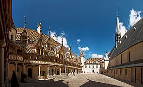
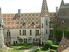
Hospices de Beaune
-
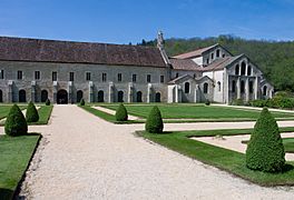
Abbey of Fontenay
-
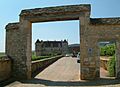
Château de la Rochepot


-
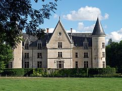
Château de Bourbilly (north side)
-
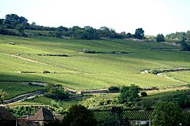
Vineyards in Côte-d'Or
-
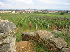
French wine region of the Côte de Beaune, Côte d'Or
.jpg)


Related pages
Images for kids
-
Clos de Vougeot, Burgundy wine
-
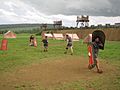
Reenactment of the siege of Alesia in Alise-Sainte-Reine


See also
 In Spanish: Côte-d'Or para niños
