
Montbard facts for kids
Quick facts for kids
Montbard
|
||
|---|---|---|

Montbard and the Brenne river.
|
||
|
||

Montbard
Location in France

Montbard
Location in Bourgogne-Franche-Comté
|
||
| Country | France | |
| Region | Bourgogne-Franche-Comté | |
| Department | Côte-d'Or | |
| Arrondissement | Montbard | |
| Canton | Montbard | |
| Intercommunality | Montbardois | |
| Area
1
|
46.37 km2 (17.90 sq mi) | |
| Population
(2014)
|
5,350 | |
| • Density | 115.38/km2 (298.82/sq mi) | |
| Time zone | UTC+01:00 (CET) | |
| • Summer (DST) | UTC+02:00 (CEST) | |
| INSEE/Postal code |
21425 /21500
|
|
| Elevation | 202–366 m (663–1,201 ft) (avg. 284 m or 932 ft) |
|
| Website | www.montbard.com | |
| 1 French Land Register data, which excludes lakes, ponds, glaciers > 1 km2 (0.386 sq mi or 247 acres) and river estuaries. | ||
.svg)
Montbard is a town in eastern France. It is located in the Côte-d'Or area, which is part of the Bourgogne-Franche-Comté region. Montbard is known as a commune, which is like a local district or town. It also serves as a subprefecture, meaning it's an important administrative center for its part of the department.
Contents
Discovering Montbard's Location
Montbard covers an area of about 46.4 square kilometers (about 17.9 square miles). Its average height above sea level, called its altitude, is 284 meters (932 feet). The town hall itself is at an altitude of 211 meters (692 feet).
How Far is Montbard from Other Cities?
Here's how far Montbard is from some other major cities:
| Dijon | Paris | Reims | Strasbourg | Lyon | Marseille | Nice |
|---|---|---|---|---|---|---|
| 74 km (46 mi) | 267 km (166 mi) | 230 km (143 mi) | 433 km (269 mi) | 248 km (154 mi) | 559 km (347 mi) | 714 km (444 mi) |
Montbard's Neighbors
Montbard is surrounded by several other towns, or communes. You can see them on the map below.

The towns around Montbard include:
 |
Verdonnet Planay |
Savoisy | Étais | |
| Arrans Saint-Rémy Quincerot |
Touillon Marmagne |
|||
| Crépand | Montigny-Montfort | Nogent-lès-Montbard |
Montbard is located northwest of Dijon, which is the capital city of the Côte-d'Or department. The town is also situated in the valley of the Brenne river.
Montbard's Climate
Montbard has a Marine West Coast Climate. This means it usually has mild winters and warm summers. This type of climate is also known as Cfb in the Köppen climate classification system.
Who Lives in Montbard?
The people who live in Montbard are called Montbardois (for men) and Montbardoises (for women) in French.
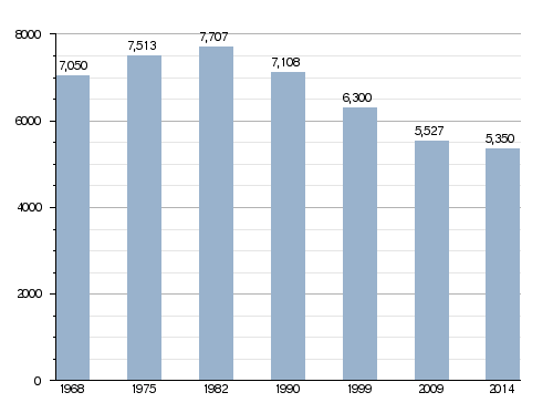
In 2014, Montbard had a population of 5,350 people. This means there were about 115 people living in each square kilometer of the town. This is called the population density.
How Montbard's Population Has Changed
The chart below shows how the number of people living in Montbard has changed over the years.
Evolution of the population in Montbard
How Montbard is Governed
Montbard has been an important administrative center, or subprefecture, for the Côte-d'Or department since 1926. It is also the main town of the arrondissement of Montbard. An arrondissement is a type of administrative district in France.
Montbard is also the administrative centre (which means chef-lieu in French) of the canton of Montbard. A canton is a smaller administrative area. This canton includes 57 different communes and had a total of 18,764 people living there in 2014.
Friends Around the World: Twin Towns
Montbard has special friendships with other towns around the world. These are called twin towns:
Images for kids
Here are some pictures of Montbard:
-
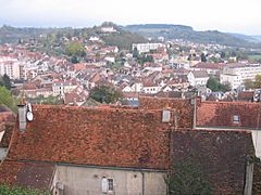
A view of Montbard.
-
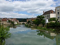
The Brenne river flowing through Montbard.
-
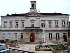
The Town hall building in Montbard.
-
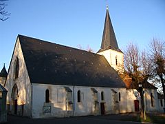
The beautiful St-Urse church.

_(3).jpg)


Related pages
See also
 In Spanish: Montbard para niños
