
Bourgogne-Franche-Comté facts for kids
Quick facts for kids Bourgogne-Franche-Comté |
|||
| Region | |||
|
|||
| Country | |||
|---|---|---|---|
| Préfecture | Besançon | ||
| - coordinates | 47°19′23″N 5°2′31″E / 47.32306°N 5.04194°E | ||
| Area | 47,783.3 km² (18,449 sq mi) | ||
| Population | 2,820,623 (2014) | ||
| Density | 59 /km² (153 /sq mi) | ||
| Subdivisions | 8 departments 24 arrondissements 152 cantons 3739 communes |
||
| President | Marie-Guite Dufay | ||
| Timezone | CET (UTC+1) | ||
| - summer (DST) | CEST (UTC+2) | ||
| ISO 3166-2 | FR-BFC | ||


Bourgogne-Franche-Comté is one of the 18 regions in France. Its name means Burgundy–Free County. This region is in eastern France. It was created in 2016 by joining two older regions: Bourgogne and Franche-Comté.
The main city and capital of Bourgogne-Franche-Comté is Besançon.
Contents
Geography of Bourgogne-Franche-Comté

Bourgogne-Franche-Comté is the sixth largest region in France. It covers an area of about 47,783.3 km2 (18,449 sq mi). It is located in northeastern France.
The region shares borders with several other French regions:
- To the north: Grand Est
- To the west: Île-de-France and Centre-Val de Loire
- To the south: Auvergne-Rhône-Alpes
It also borders Switzerland to the east. The Swiss areas next to it are the cantons of Vaud, Neuchâtel, and Jura.
Distances from Besançon
Besançon is the capital city of the region. Here are some distances from Besançon to other major French cities:
- Paris, the capital of France, is 410 km (255 mi) away.
- Lyon is 227 km (141 mi) away.
- Marseille is 538 km (334 mi) away.
Rivers in the Region
Several important rivers flow through Bourgogne-Franche-Comté:
- The Saône river is a major waterway.
- The Doubs river is a tributary (a smaller river that flows into a larger one) of the Saône.
- The Loire river, one of France's longest, flows through the southwest part of the region near Nevers.
- The Seine river, famous for flowing through Paris, actually starts in the Côte-d'Or department of this region.
Mountains in Bourgogne-Franche-Comté
The region has three main mountain ranges:
- The Vosges Mountains are in the northeast. The highest point in this range within Bourgogne-Franche-Comté is Ballon de Servance, which is 1,216 m (3,990 ft) high.
- The Jura Mountains are along the eastern border with Switzerland. The highest point in the entire Bourgogne-Franche-Comté region is here: Crêt Pela, at 1,495 m (4,905 ft).
- The Morvan mountains are in the western part of the region. Its highest point is Haut-Folin, 901 m (2,956 ft) high.
The Crêt Pela is the highest mountain in the Bourgogne-Franche-Comté region. It is 1,495 m (4,905 ft) tall and is part of the Jura range.
Here are the highest points in each of the region's departments:
| Department | Mountain | Elevation |
|---|---|---|
| Côte-d'Or | Mont de Gien | 721 m (2,365 ft) |
| Doubs | Mont d'Or | 1,461 m (4,793 ft) |
| Jura | Crêt Pela | 1,495 m (4,905 ft) |
| Nièvre | Mont Préneley | 855 m (2,805 ft) |
| Haute-Saône | Ballon de Servance | 1,216 m (3,990 ft) |
| Saône-et-Loire | Haut-Folin | 901 m (2,956 ft) |
| Yonne | Bois de la Pérouse | 607 m (1,991 ft) |
| Territoire de Belfort | Ballon d'Alsace | 1,247 m (4,091 ft) |
Departments of Bourgogne-Franche-Comté
The Bourgogne-Franche-Comté region is made up of 8 smaller areas called departments. Each department has its own main city, called a prefecture.
| ISO 3166-2 |
Shield | Department | Prefecture | Arr. | Cant. | Comm. | Population (2014) |
Area (km²) |
Density (Inh./km²) |
|---|---|---|---|---|---|---|---|---|---|
| FR-21 | Côte-d'Or | Dijon | 3 | 23 | 704 | 531,380 | 8,763.2 | 60.6 | |
| FR-25 | Doubs | Besançon | 3 | 19 | 578 | 534,710 | 5,232.6 | 102.2 | |
| FR-39 | Jura | Lons-le-Saunier | 3 | 17 | 509 | 260,681 | 4,999.2 | 52.1 | |
| FR-58 | Nièvre | Nevers | 4 | 17 | 309 | 213,569 | 6,816.7 | 31.3 | |
| FR-70 | Haute-Saône | Vesoul | 2 | 17 | 542 | 238,347 | 5,360.1 | 44.5 | |
| FR-71 | Saône-et-Loire | Mâcon | 5 | 29 | 567 | 555,788 | 8,574.7 | 64.8 | |
| FR-89 | Yonne | Auxerre | 3 | 21 | 428 | 341,814 | 7,427.4 | 46.0 | |
| FR-90 | Territoire de Belfort | Belfort | 1 | 9 | 102 | 144,334 | 609.4 | 236.8 | |
| Total of the Region | 24 | 152 | 3,739 | 2,820,623 | 47,783.3 | 59.0 | |||
Arr. = Arrondissements Cant. = Cantons Comm. = Communes
Population of Bourgogne-Franche-Comté
In 2014, the Bourgogne-Franche-Comté region had a population of 2,820,623 people. This means there were about 59.0 inhabitants per square kilometer.
The department with the most people is Saône-et-Loire, with 555,788 residents. After the Territoire de Belfort, which is the smallest department, Doubs has the highest population density with 102 people per square kilometer. Other departments have fewer people living in each square kilometer.
Gallery


Related pages
Images for kids
-
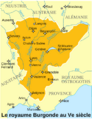
The Kingdom of Burgundy during the 5th century.
-
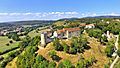
Belvoir Castle
-
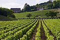
Vineyards in Volnay


See also
 In Spanish: Borgoña-Franco Condado para niños
