
Doubs (river) facts for kids
Quick facts for kids Doubs |
|
| German: Dub | |
| River | |
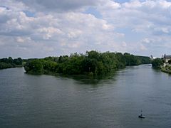
 The Doubs just before Besançon.
|
|
| Countries | |
|---|---|
| Regions | Bourgogne-Franche-Comté, French-speaking Switzerland |
| Tributaries | |
| - left | Drugeon, Loue, Guyotte |
| - right | Allaine |
| Cities | Pontarlier, Besançon, Dole |
| Source | Jura Mountains |
| - location | Mouthe, Doubs, France |
| - elevation | 937 m (3,074 ft) |
| - coordinates | 46°42′18″N 6°12′34″E / 46.70500°N 6.20944°E |
| Confluence | Saône |
| - location | Verdun-sur-le-Doubs, Saône-et-Loire, France |
| - elevation | 170 m (558 ft) |
| - coordinates | 46°54′5″N 5°1′26″E / 46.90139°N 5.02389°E |
| Length | 453 km (281 mi) |
| Basin | 7,710 km² (2,977 sq mi) |
| Discharge | for Neublans-Abergement |
| - average | 173 m³/s (6,109 cu ft/s) |
The Doubs is a river that flows through eastern France and western Switzerland. It's a major branch of the Saône river. The Doubs flows through the Bourgogne-Franche-Comté region in France and the French-speaking part of Switzerland.
The French department called Doubs is named after this river.
Contents
River Doubs: Its Path and Size
The Doubs river is about 453 km (281.5 mi) long. The area of land that drains into the river, called its drainage basin, is 7,710 km2 (2,977 sq mi).
The average amount of water flowing through the river each second is 173 m3/s (6,100 cu ft/s). This measurement was taken near Neublans-Abergement. This town is in the Jura department, close to where the Doubs joins the Saône river.
Where the Doubs River Starts
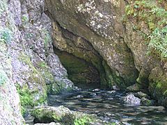
The Doubs river begins in a French town called Mouthel. This town is in the Doubs department. The river starts high up in the Jura Mountains, about 937 m (3,074 ft) above sea level. This area is very close to the border between France and Switzerland.
The river first flows towards the northeast. It passes through a lake called Lac de Saint-Point. Then, for several kilometers, it forms the border between France and Switzerland.
Doubs River's Journey
After forming the border, the Doubs river enters Switzerland. It flows into the Jura canton, in a region known as Clos du Doubs. A famous waterfall called Saut du Doubs is found right on the French-Swiss border.
The river then turns west and flows back into France. Finally, it travels southwest until it meets the Saône river.
The Doubs river flows through one region and three departments in France. It also goes through two cantons in Switzerland: Neuchâtel and Jura. Some of the towns it passes through include:
- In the Bourgogne-Franche-Comté region (first part):
- In Switzerland:
- Jura canton: Saint-Ursanne
- In the Bourgogne-Franche-Comté region (second part):
- Doubs: Besançon
- Jura: Dole
- Saône-et-Loire: Verdun-sur-le-Doubs
-
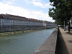
The Doubs in Besançon.
-
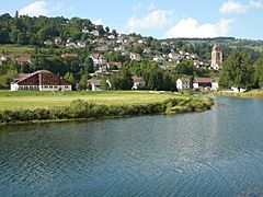
The Doubs in Morteau.
-
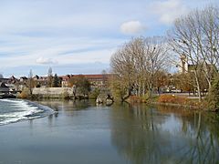
The Doubs in Dole.
-
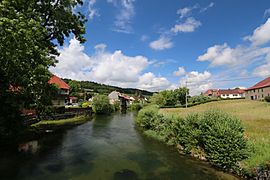
The Doubs near Mouthe, where it starts.


.jpg)

Lakes Formed by the Doubs
The Doubs river creates several lakes along its path:
- Lac des Brenets (about 750 m [2,460 ft] high)
- Lac de Moron (about 716 m [2,349 ft] high)
- Lac de Biaufond (about 610 m [2,000 ft] high)
The Doubs river eventually flows into the Saône river. It joins the Saône as a left branch in the town of Verdun-sur-le-Doubs.
Main Rivers Joining the Doubs
Many smaller rivers flow into the Doubs. These are called tributaries. Here are the main ones that are longer than 30 km:
|
Rivers joining from the left:
|
Rivers joining from the right:
|
Using the Doubs for Electricity
The Doubs river is used to make electricity. This is called hydroelectricity. There are several power stations along the river. Two of the most important ones are:
- The Dam of Châtelot, which is 74 m (243 ft) tall.
- The Dam of Refrain, which is 66.5 m (218 ft) tall.
Gallery
-
The source of the Doubs in Mouthe.
-
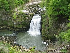
The Saut du Doubs waterfall.
-
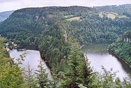
The Lac des Brenets.
-
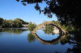
The Doubs in Dole.
-
The point where the Saône (left) and Doubs (right) rivers meet.


Related pages
Images for kids
-
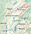
The path of the Doubs river.
-
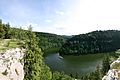
The Lac de Brenets.
-
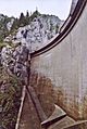
The Dam of Châtelot, finished in 1953.


See also
 In Spanish: Río Doubs para niños
