
Doubs facts for kids
Quick facts for kids
Doubs
|
|||
|---|---|---|---|
_(adjusted).jpg)
Prefecture building of the Doubs department, in Besançon
|
|||
|
|||

Doubs in France
|
|||
| Country | France | ||
| Region | Bourgogne-Franche-Comté | ||
| Département | 4 March 1790 | ||
| Prefecture | Besançon | ||
| Subprefectures | Montbéliard, Pontarlier | ||
| Area | |||
| • Total | 5,232.6 km2 (2,020.3 sq mi) | ||
| Population
(2014)
|
|||
| • Total | 534,710 | ||
| • Density | 102.1882/km2 (264.666/sq mi) | ||
| Demonym(s) | Doubistes | ||
| Time zone | UTC+1 (CET) | ||
| • Summer (DST) | UTC+2 (CEST) | ||
| ISO 3166 code | FR-25 | ||
| Arrondissements | 3 | ||
| Cantons | 19 | ||
| Communes | 578 | ||
| Website | www.doubs.fr | ||


The Doubs is a special area in eastern France. It is called a department. This department is part of the Bourgogne-Franche-Comté region. It gets its name from the Doubs river that flows through it.
The biggest city in the Doubs department is Besançon. This city is also its prefecture, which means it's like the main capital city for the department.
Contents
History of Doubs
The Doubs department was created a long time ago, on March 4, 1790. This happened during the French Revolution. It was one of the first 83 departments in France.
The land for Doubs came from an old area called Franche-Comté. Besançon was chosen as its capital from the very beginning.
At first, Doubs was split into six smaller areas called districts. Later, in 1800, these changed into four arrondissements. These are like smaller administrative areas.
After a big battle called the Battle of Waterloo in 1815, the Austrian army took over the department for a few years. They stayed from June 1815 until November 1818.
Over time, some of these arrondissements changed. For example, in 1926, one of them, Baume-les-Dames, was removed.
Geography of Doubs
Doubs is located in the Bourgogne-Franche-Comté region of France. It covers an area of about 5,232.6 square kilometers (2,020.3 square miles).
The department shares its borders with three other French departments. These are Jura, Haute-Saône, and Territoire de Belfort. It also borders three areas of Switzerland. These Swiss areas are called Vaud, Neuchâtel, and Jura.
Part of the Doubs department is in the Jura Mountains. This is especially true for the eastern side, near the Swiss border. The highest point in Doubs is a mountain called Mont d'Or. It is 1,461 meters (4,793 feet) tall. This mountain is located near the city of Pontarlier. The lowest point in the department is where the Ognon river leaves the area. It is about 200 meters (656 feet) high.
The main rivers in Doubs are the Doubs river, which the department is named after, the Ognon river, and the Loue river. The Loue river flows into the Doubs river.
Climate in Doubs
The climate in Besançon, the capital city, is an "Oceanic climate". This means it's similar to a Marine West Coast Climate. It has mild temperatures and rain throughout the year.
The average temperature in Besançon for the whole year is about 11°C (52°F). July is usually the warmest month, with an average temperature of 19.9°C (67.8°F). January is the coldest month, with an average temperature of 2.3°C (36.1°F).
Besançon gets about 934.7 millimeters (36.8 inches) of rain each year. September is often the wettest month, getting around 106.7 millimeters (4.2 inches) of rain. February is usually the driest month, with about 50.8 millimeters (2.0 inches) of rain.
How Doubs is Managed
The Doubs department is run by a group called the Departmental Council of Doubs. This council is located in Besançon. The department is part of the larger Bourgogne-Franche-Comté region.
Administrative Divisions
Doubs is divided into smaller parts to help manage it.
- There are 3 main areas called arrondissements (districts).
- Inside these, there are 19 smaller areas called cantons.
- Finally, there are 578 very small areas called communes (municipalities or towns).
| Arrondissement | Capital City | Population (2014) |
Area (km²) |
Density (People/km²) |
Number of Towns |
|---|---|---|---|---|---|
| Besançon | Besançon | 248,199 | 1,942.2 | 127.8 | 260 |
| Montbéliard | Montbéliard | 176,670 | 1,255.7 | 140.7 | 169 |
| Pontarlier | Pontarlier | 109,841 | 2,034.7 | 54.0 | 149 |
Here is a list of the 19 cantons in the Doubs department:
- Audincourt
- Baume-les-Dames
- Bavans
- Besançon-1
- Besançon-2
- Besançon-3
- Besançon-4
- Besançon-5
- Besançon-6
- Bethoncourt
- Frasne
- Maîche
- Montbéliard
- Morteau
- Ornans
- Pontarlier
- Saint-Vit
- Valdahon
- Valentigney
People of Doubs
The people who live in Doubs are called Doubistes or Doubiens (for men) and Doubiennes (for women) in French.
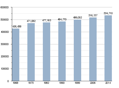
In 2014, Doubs had a population of 534,710 people. This means there were about 102.2 people living in each square kilometer. The arrondissement of Besançon had the most people, with 248,199 residents.
How the population in Doubs has changed over time
Here are the cities in Doubs with the most people:
| City | Population (2014) |
Arrondissement |
|---|---|---|
| Besançon | 116,690 | Besançon |
| Montbéliard | 25,521 | Montbéliard |
| Pontarlier | 17,413 | Pontarlier |
| Audincourt | 14,131 | Montbéliard |
| Valentigney | 9,970 | Montbéliard |
| Morteau | 6,827 | Pontarlier |
| Seloncourt | 5,906 | Montbéliard |
| Bethoncourt | 5,729 | Montbéliard |
| Grand-Charmont | 5,535 | Montbéliard |
| Valdahon | 5,344 | Pontarlier |
Places to Visit
Doubs has many interesting places to see:
- The Citadel of Besançon, an old fortress.
- The Royal Saltworks at Arc-et-Senans, a historic salt factory.
- The castle of Montbéliard.
- The Fort de Joux, another old fort.
- The beautiful village of Lods.
Gallery
-
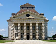
Royal Saltworks at Arc-et-Senans.
-
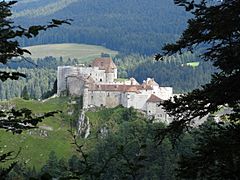
Fort de Joux.
-
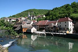
Lods, one of the most beautiful villages of France.
-
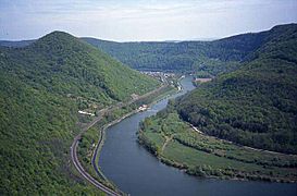
The Doubs river is the main river of the department.


.JPG)

Related pages
See also
 In Spanish: Doubs para niños
