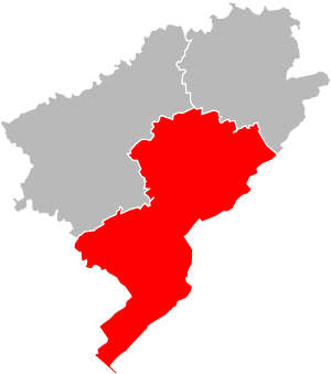
Arrondissement of Pontarlier facts for kids
Quick facts for kids
Arrondissement of Pontarlier
|
|
|---|---|

Location of Pontarlier in Doubs
|
|
| Country | France |
| Region | Bourgogne-Franche-Comté |
| Department | Doubs |
| Communes | 149 |
| Subprefecture | Pontarlier |
| INSEE code | 253 |
| Area | |
| • Total | 2,034.7 km2 (785.6 sq mi) |
| Population
(2014)
|
|
| • Total | 109,841 |
| • Density | 53.9839/km2 (139.818/sq mi) |
The arrondissement of Pontarlier is a special area in France. Think of it like a district or a large county. It's part of the Doubs département, which is like a bigger region. This arrondissement is located in the Bourgogne-Franche-Comté region of France. The main town and capital of this area is Pontarlier.
History
The arrondissements in France were created a long time ago, in 1800. Pontarlier was one of the first arrondissements to be set up in the Doubs area.
Geography
The Pontarlier arrondissement is in the southern part of the Doubs département. It's the largest arrondissement in the area, covering about 2,034.7 square kilometers (which is about 785.6 square miles).
It has about 109,841 people living there. This makes it the arrondissement with the fewest people in the Doubs département. The population density is about 54 people per square kilometer. This means there are about 54 people living in an area the size of one square kilometer.
The Pontarlier arrondissement is surrounded by other areas. To the north, it borders the Montbéliard arrondissement. To the east and south, it shares a border with Switzerland. The Jura département is to its southeast. To the west, it borders the Besançon arrondissement.
How Pontarlier is Organized
Cantons
In France, cantons are like smaller voting areas. They are not always fully inside one arrondissement. This means a canton can have towns that belong to different arrondissements.
In the Pontarlier arrondissement, there are two cantons that are split. These are Ornans and Valdahon.
Communes
The Pontarlier arrondissement has 149 communes. A commune is the smallest local government area in France, similar to a town or a village.
Here are some of the communes in the arrondissement that have the most people:
| INSEE Code |
Commune | Population (2014) |
Canton | Intercommunality |
|---|---|---|---|---|
| 25462 | Pontarlier | 17,413 | Pontarlier | Le Grand Pontarlier |
| 25411 | Morteau | 6,827 | Morteau | Le Val de Morteau |
| 25578 | Valdahon | 5,344 | Valdahon | Le Pays de Pierrefontaine - Vercel |
| 25321 | Villers-le-Lac | 4,750 | Morteau | Le Val de Morteau |
| 25240 | Les Fins | 3,035 | Morteau | Le Val de Morteau |
| 25204 | Doubs | 2,808 | Pontarlier | Le Grand Pontarlier |
| 25512 | Le Russey | 2,256 | Morteau | Le Plateau de Russey |
| 25432 | Orchamps-Vennes | 2,047 | Valdahon | Le Pays de Pierrefontaine - Vercel |
| 25334 | Levier | 2,035 | Frasne and Ornans | Altitude 800 |
| 25403 | Montlebon | 2,010 | Morteau | Le Val de Morteau |
Related pages
See also
 In Spanish: Distrito de Pontarlier para niños
 | Mary Eliza Mahoney |
 | Susie King Taylor |
 | Ida Gray |
 | Eliza Ann Grier |

