
Territoire de Belfort facts for kids
Quick facts for kids
Territoire de Belfort
|
|||
|---|---|---|---|

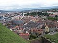
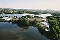
Belfort city.
|
|||
|
|||

Location of Territoire de Belfort in France
|
|||
| Country | France | ||
| Region | Bourgogne-Franche-Comté | ||
| Département | 11 March 1922 | ||
| Prefecture | Belfort | ||
| Subprefectures | (none) | ||
| Area | |||
| • Total | 609.4 km2 (235.3 sq mi) | ||
| Population | |||
| • Total | 144,334 | ||
| • Density | 236.846/km2 (613.43/sq mi) | ||
| Demonym(s) | Terrifortains | ||
| Time zone | UTC+1 (CET) | ||
| • Summer (DST) | UTC+2 (CEST) | ||
| ISO 3166 code | FR-90 | ||
| Arrondissements | 1 | ||
| Cantons | 9 | ||
| Communes | 102 | ||
| Website | Official website: http://www.territoiredebelfort.fr/ | ||


Territoire de Belfort is a special area in eastern France. It's like a small state or county, called a department. It's part of the Bourgogne-Franche-Comté region. The biggest city and capital of this area is Belfort.
Contents
A Look Back in Time
The Territoire de Belfort became an official French department on March 11, 1922.
Where is Territoire de Belfort?
Territoire de Belfort is located in the northeast of the Bourgogne-Franche-Comté region. It's quite small, covering about 609.4 square kilometers (235.3 square miles). This makes it the fifth smallest department in France.
Neighboring Areas
The Territoire de Belfort shares its borders with four other French departments:
- In the Grand Est region:
- In the Bourgogne-Franche-Comté region:
- Doubs (to the south)
- Haute-Saône (to the west)
It also borders Switzerland to the southeast for about 25 kilometers (15.5 miles).
 |
Vosges | |
||
| Haute-Saône | Haut-Rhin | |||
| Doubs | Switzerland |
Mountains and Rivers
The highest point in the department is a mountain called Ballon d'Alsace. It stands tall at 1,247 meters (4,091 feet) in the Vosges Mountains. You can find it near the town of Lepuix.
The lowest point is 329 meters (1,079 feet) high. This is where the Savoureuse river leaves the department, near the town of Châtenois-les-Forges.
How Territoire de Belfort is Governed
The Territoire de Belfort is managed by the Departmental Council of Territoire de Belfort. This council is located in the city of Belfort. The department is part of the larger Bourgogne-Franche-Comté region.
Local Divisions
Territoire de Belfort is divided into smaller areas to help with its administration:
- There is 1 arrondissement (a large district).
- There are 9 cantons (smaller administrative areas).
- There are 102 communes (which are like local towns or municipalities).
| INSEE code |
Arrondissement | Capital | Population (2014) |
Area (km²) |
Density (Inh./km²) |
Communes |
|---|---|---|---|---|---|---|
| 901 | Belfort | Belfort | 144,334 | 609.4 | 236.8 | 102 |
The 9 cantons of Territoire de Belfort are:
- Bavilliers
- Belfort-1
- Belfort-2
- Belfort-3
- Châtenois-les-Forges
- Delle
- Giromagny
- Grandvillars
- Valdoie
People of Territoire de Belfort
The people who live in Territoire de Belfort are called Terrifortains (for men) or Terrifortaines (for women) in French.
In 2014, about 144,334 people lived in Territoire de Belfort. This means there were about 236.8 people per square kilometer (613.3 people per square mile).
Related pages
Images for kids
-
Northern Belfort city.
-
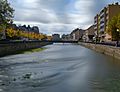
The Savoureuse river in Belfort.
-
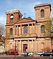
The St. Christophe cathedral, Belfort.
-
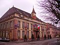
City hall, Belfort.
-
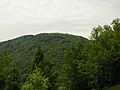
The Ballon d'Alsace mountain.
-
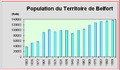
Population trends in the Territoire-de-Belfort.
-
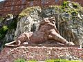
The Lion of Belfort commemorates the resistance of Belfort during the Franco-Prussian War.
-
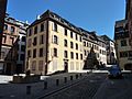
Streets in Belfort
-
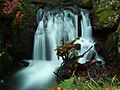
Cascade of the Savoureuse river
-
Eurockéennes music festival


_(1).jpg)


See also
 In Spanish: Territorio de Belfort para niños
