
Haut-Rhin facts for kids
Quick facts for kids
Haut-Rhin
|
|||
|---|---|---|---|
![Prefecture]building of the Haut-Rhin department, in Colmar](/Image:Colmar_Prefecture.JPG)
Prefecture building of the Haut-Rhin department, in Colmar
|
|||
|
|||

Location of Haut-Rhin in France
|
|||
| Country | France | ||
| Region | Grand Est | ||
| Département | 4 March 1790 | ||
| Prefecture | Colmar | ||
| Subprefectures | Altkirch, Mulhouse, Thann | ||
| Area | |||
| • Total | 3,525.2 km2 (1,361.1 sq mi) | ||
| Population
(2014)
|
|||
| • Total | 760,134 | ||
| • Density | 215.629/km2 (558.476/sq mi) | ||
| Demonym(s) | Haut-Rhinois | ||
| Time zone | UTC+1 (CET) | ||
| • Summer (DST) | UTC+2 (CEST) | ||
| ISO 3166 code | FR-68 | ||
| Arrondissements | 4 | ||
| Cantons | 17 | ||
| Communes | 366 | ||


Haut-Rhin is a special area in France, like a county or state. It's part of the Grand Est region. Its name means Upper Rhine, and it's named after the big Rhine river that flows along its eastern side. The main city, or capital, of Haut-Rhin is Colmar.
Contents
History of Haut-Rhin
Haut-Rhin was one of the first 83 departments created in France. This happened on March 4, 1790, during the French Revolution. Back then, it was split into three smaller areas called districts: Altkirch, Belfort, and Colmar. Colmar was already its capital.
In 1800, France created new administrative areas called arrondissements. The three districts in Haut-Rhin became five arrondissements: Colmar, Altkirch, Belfort, Delémont, and Porrentruy. However, in 1814, Delémont and Porrentruy were given to Switzerland.
Later, in 1857, the main office of Altkirch was moved to Mulhouse.
Haut-Rhin stopped being a French department in 1871. This was because most of its land became part of Germany. A small part of it became a new area called the Territoire de Belfort.
But in 1919, Haut-Rhin became a French department again. This happened after World War I, when the land returned to France. At that time, it had several arrondissements: Colmar-Ville, Colmar-Campagne, Altkirch, Guebwiller, Mulhouse, Ribeauvillé, and Thann. Colmar remained its capital.
In 1934, the Colmar-Ville and Colmar-Campagne arrondissements were combined. They formed one arrondissement simply called Colmar.
More recently, in 2015, some changes happened again. The arrondissements of Guebwiller and Ribeauvillé were removed. The names of Thann and Colmar arrondissements were changed to Thann-Guebwiller and Colmar-Ribeauvillé.
Geography of Haut-Rhin
Haut-Rhin is the smaller of the two departments that used to make up the Alsace region. It's also less populated. It is located in the Grand Est region of France.
Borders and Neighbors
Haut-Rhin shares its borders with three other departments in France:
- In the Grand Est region:
- In the Bourgogne-Franche-Comté region:
- Territoire de Belfort to the southwest.
To the east, the department borders Germany along the Rhine river. To the south, it borders Switzerland.
 |
Vosges | Bas-Rhin | |
|
| Vosges | Germany | |||
| Territoire de Belfort | Switzerland |
Mountains and Rivers
Haut-Rhin covers an area of about 3,525.2 square kilometers (1,361.1 sq mi). Its highest point is a mountain called Grand Ballon. It's part of the Vosges Mountains and is 1,424 meters (4,672 ft) high. The lowest point in the department is 179 meters (587 ft) high, found along the Rhine river.
The main river in Haut-Rhin is the Rhine. It forms the eastern border of the department and also part of the border of France.
Climate in Haut-Rhin
The area around Colmar has a climate with mild temperatures. It's known as a "Marine West Coast Climate." This means it doesn't get too hot or too cold.
The average rainfall in Strasbourg, a nearby city, is about 594.4 millimeters (23.4 in) per year. June usually has the most rain, with about 71.1 millimeters (2.8 in). February is the driest month, with only about 33 millimeters (1.3 in) of rain.
The average yearly temperature in Strasbourg is 10 °C (50 °F). July is the warmest month, averaging 18.9 °C (66.0 °F). January is the coolest, with an average temperature of 1.1 °C (34.0 °F).
How Haut-Rhin is Managed
Haut-Rhin is run by the Departmental Council of Haut-Rhin. This council is located in Colmar. The department is also part of the larger Grand Est region.
Administrative Divisions
Haut-Rhin is divided into smaller administrative areas. These include:
- 4 arrondissements (districts)
- 17 cantons (smaller groups of towns)
- 366 communes (individual towns or municipalities)
Here are the arrondissements of Haut-Rhin:
| INSEE code |
Arrondissement | Capital | Population (2014) |
Area (km²) |
Density (Inh./km²) |
Communes |
|---|---|---|---|---|---|---|
| 681 | Altkirch | Altkirch | 69,645 | 663.1 | 105.0 | 108 |
| 682 | Colmar-Ribeauvillé | Colmar | 200,243 | 1,127.3 | 177.6 | 98 |
| 684 | Mulhouse | Mulhouse | 350,032 | 707.1 | 495.0 | 79 |
| 686 | Thann-Guebwiller | Thann | 140,214 | 1,027.7 | 136.4 | 81 |
Here are the 17 cantons of the Haut-Rhin department, updated in March 2015:
- Altkirch (6801)
- Brunstatt (6802)
- Cernay (6803)
- Colmar-1 (6804)
- Colmar-2 (6805)
- Ensisheim (6806)
- Guebwiller (6807)
- Kingersheim (6808)
- Masevaux (6809)
- Mulhouse-1 (6810)
- Mulhouse-2 (6811)
- Mulhouse-3 (6812)
- Rixheim (6813)
- Saint-Louis (6814)
- Sainte-Marie-aux-Mines (6815)
- Wintzenheim (6816)
- Wittenheim (6817)
Population of Haut-Rhin
People who live in the Haut-Rhin department are called Haut-Rhinois (for men) or Haut-Rhinoises (for women) in French.
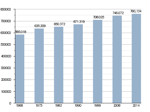
In 2014, Haut-Rhin had a population of 760,134 people. This means there were about 215.6 people per square kilometer (558 people per sq mi). The arrondissement of Mulhouse is the most populated, with 350,032 residents.
Population Changes Over Time
The number of people living in Haut-Rhin has grown steadily over the years.
Evolution of the population in Haut-Rhin
Largest Towns in Haut-Rhin
Here are the 10 towns (communes) in Haut-Rhin with the most people, based on 2014 data:
| City | Population (2014) |
Arrondissement |
|---|---|---|
| Mulhouse | 111,167 | Mulhouse |
| Colmar | 68,784 | Colmar-Ribeauvillé |
| Saint-Louis | 20,228 | Mulhouse |
| Wittenheim | 14,713 | Mulhouse |
| Illzach | 14,448 | Mulhouse |
| Rixheim | 13,773 | Mulhouse |
| Kingersheim | 12,918 | Mulhouse |
| Riedisheim | 12,102 | Mulhouse |
| Cernay | 11,723 | Thann-Guebwiller |
| Guebwiller | 11,297 | Thann-Guebwiller |
Gallery


Images for kids
-
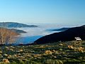
View from the Ballon d'Alsace


Related pages
See also
 In Spanish: Alto Rin para niños
