
Haute-Saône facts for kids
Quick facts for kids
Haute-Saône
|
||
|---|---|---|

Departmental Council building of the Haute-Saône department, in Vesoul
|
||
|
||

Haute-Saône in France
|
||
| Country | France | |
| Region | Bourgogne-Franche-Comté | |
| Département | 4 March 1790 | |
| Prefecture | Vesoul | |
| Subprefectures | Lure | |
| Area | ||
| • Total | 5,360.1 km2 (2,069.5 sq mi) | |
| Population
(2014)
|
||
| • Total | 238,347 | |
| • Density | 44.4669/km2 (115.1687/sq mi) | |
| Demonym(s) | Haut-Saônois | |
| Time zone | UTC+1 (CET) | |
| • Summer (DST) | UTC+2 (CEST) | |
| ISO 3166 code | FR-70 | |
| Arrondissements | 2 | |
| Cantons | 17 | |
| Communes | 542 | |
| Website | www.haute-saone.fr | |

Haute-Saône is a special area in eastern France, like a big county. It's part of the Bourgogne-Franche-Comté region. The area is named after the Saône river that flows through it. The main city, or capital, of Haute-Saône is Vesoul.
Contents
History of Haute-Saône
Haute-Saône was one of the first 83 "departments" created in France. This happened on March 4, 1790, during the French Revolution. It was formed from a part of an older area called Franche-Comté.
At first, Haute-Saône was split into six smaller areas called "districts." These districts had different main towns like Jussey, Luxeuil, Lure, Vesoul, Gray, and Champlitte. The capital of the department kept changing between Gray and Vesoul. By 1794, Gray was the only capital.
Later, in 1800, these districts were changed into three larger areas called arrondissements. These new areas were Vesoul, Gray, and Lure. The capital was then officially moved from Gray to Vesoul.
After a big battle called the Battle of Waterloo in 1815, the department was taken over by the Austrian army. They stayed there for about three years, from June 1815 to November 1818.
In 1926, the arrondissement of Gray was removed, leaving just two main areas.
Geography and Climate
Haute-Saône is located in the Bourgogne-Franche-Comté region. It covers an area of about 5,360 square kilometers (2,070 square miles).
The department shares its borders with six other departments:
- In the Bourgogne-Franche-Comté region:
- Côte-d'Or (to the southwest)
- Doubs (to the east)
- Jura (to the south)
- Territoire de Belfort (to the east)
- In the Grand Est region:
- Haute-Marne (to the west)
- Vosges (to the north)
 |
Vosges | Territoire de Belfort | |
|
| Haute-Marne | Doubs | |||
| Côte-d'Or | Jura | Doubs |
The most important river in Haute-Saône is the Saône. It flows through the department from the northeast to the southwest. The highest point in the department is a mountain called Ballon de Servance. It stands at 1,216 meters (3,990 feet) tall and is located in the town of Servance-Miellin.
Climate in Haute-Saône
The climate in Haute-Saône, especially around Lure, is known as an "Oceanic climate". This means it's similar to the climate near the ocean, with mild temperatures.
The average temperature for the whole year in Lure is about 9.4°C (48.9°F). The warmest month is usually July, with an average temperature of 17.2°C (63.0°F). The coldest month is January, with an average temperature of 0.6°C (33.1°F).
On average, Lure gets about 744.2 millimeters (29.3 inches) of rain each year. August is usually the wettest month, with about 88.9 millimeters (3.5 inches) of rain. March is the driest month, with only about 43.2 millimeters (1.7 inches) of rain.
Government and Divisions
Haute-Saône is run by the Departmental Council of Haute-Saône, which is based in Vesoul. This department is part of the larger Bourgogne-Franche-Comté region.
Administrative Divisions
Haute-Saône is divided into different administrative areas to help manage it. There are:
- 2 arrondissements (which are like large districts)
- 17 cantons (smaller areas for elections and local services)
- 542 communes (these are like towns or municipalities)
Here's a quick look at the two main arrondissements:
| Arrondissement | Capital City | Population (2014) |
Area (km²) |
Number of Towns |
|---|---|---|---|---|
| Lure | Lure | 108,725 | 1,848.3 | 195 |
| Vesoul | Vesoul | 129,622 | 3,511.8 | 347 |
The 17 cantons in Haute-Saône were reorganized in March 2015. They include:
- Dampierre-sur-Salon
- Gray
- Héricourt-1
- Héricourt-2
- Jussey
- Lure-1
- Lure-2
- Luxeuil-les-Bains
- Marnay
- Mélisey
- Port-sur-Saône
- Rioz
- Saint-Loup-sur-Semouse
- Scey-sur-Saône-et-Saint-Albin
- Vesoul-1
- Vesoul-2
- Villersexel
Population of Haute-Saône
The people who live in Haute-Saône are called Haut-Saônois in French.
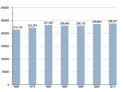
In 2014, Haute-Saône had a population of 238,347 people. This means there were about 44.5 people living in each square kilometer (115 people per square mile). The arrondissement of Vesoul has the most people, with 129,622 residents.
How the population of Haute-Saône has changed over time:
Here are the largest cities in Haute-Saône by population:
| City | Population (2014) |
Arrondissement |
|---|---|---|
| Vesoul | 15,212 | Vesoul |
| Héricourt | 9,967 | Lure |
| Lure | 8,324 | Lure |
| Luxeuil-les-Bains | 6,917 | Lure |
| Gray | 5,504 | Vesoul |
| Champagney | 3,797 | Lure |
| Fougerolles | 3,721 | Lure |
| Saint-Loup-sur-Semouse | 3,263 | Lure |
| Échenoz-la-Méline | 3,203 | Vesoul |
| Port-sur-Saône | 3,039 | Vesoul |
Places to See
Haute-Saône has many interesting places to visit, from old churches to beautiful castles and natural landscapes.
-
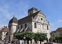
The Saint-Georges church in Vesoul.
-
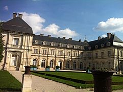
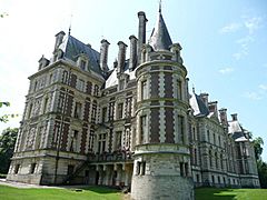
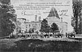
The Château de Champlitte, a historic castle.
-
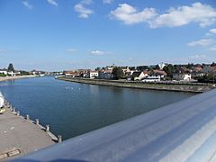
The Saône river flowing through Gray.
-
The Castle of Villersexel.


Related Pages
Images for kids
-
Battle of the Lisaine
-
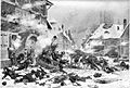
Battle of Villersexel
-
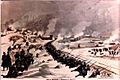
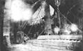
View of the destruction of Bourg de Villersexel
-
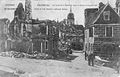
German artillery in front of the ruins of castle of Villersexel
-
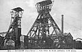
Arthur de Buyer Coal Mine (1,010 m) was the deepest coal mine in France between 1900 and 1910.
-
Gouhenans Saltworks was one of the most important saltworks in France in the 19th century.
-
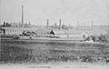
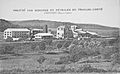
Inside the Varigney factory (Dampierre-lès-Conflans), where iron was made until the mid-20th century.
-
Creveney bituminous shale distillation plant, a rare operation in France between the two world wars.
-
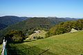
A beautiful landscape in the southeast of the department.
-
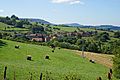
Ray-sur-Saône in the west of the department.
-
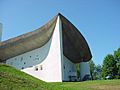
Notre-Dame du Haut by Le Corbusier, a UNESCO World Heritage site.
-
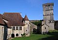
Château d'Oricourt, a medieval castle.
-
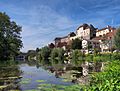
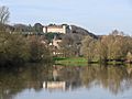
Pesmes, with its castle seen from an island.
-
La Planche des Belles Filles, a famous climb in the Tour de France.
-
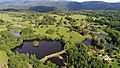
A landscape from the Plateau des Mille Étangs (Plateau of a Thousand Ponds).


.jpg)


_-_01.jpg)


See also
 In Spanish: Alto Saona para niños
