
Haute-Marne facts for kids
Quick facts for kids
Haute-Marne
|
|||
|---|---|---|---|

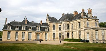
Prefecture building of the Haute-Marne department, in Chaumont
|
|||
|
|||

Location of Haute-Marne in France
|
|||
| Country | France | ||
| Region | Grand Est | ||
| Département | 4 March 1790 | ||
| Prefecture | Chaumont | ||
| Subprefectures | Langres, Saint-Dizier | ||
| Area | |||
| • Total | 6,210.6 km2 (2,397.9 sq mi) | ||
| Population
(2014)
|
|||
| • Total | 180,673 | ||
| • Density | 29.09107/km2 (75.3455/sq mi) | ||
| Time zone | UTC+1 (CET) | ||
| • Summer (DST) | UTC+2 (CEST) | ||
| ISO 3166 code | FR-52 | ||
| Arrondissements | 3 | ||
| Cantons | 17 | ||
| Communes | 427 | ||


Haute-Marne is a special area in the northeast of France. It's called a "department." It gets its name from the Marne River.
This department is part of the Grand Est region. Its main city, or "prefecture," is Chaumont. A famous French leader, Charles de Gaulle, lived in Colombey-les-Deux-Églises in Haute-Marne until he passed away.
Contents
History of Haute-Marne
Haute-Marne was one of the first 83 departments created in France. This happened during the French Revolution on March 4, 1790. Chaumont was chosen as its main city right from the start.
The department was formed from parts of older French areas. These included Champagne, Burgundy, Lorraine, and Franche-Comté.
At first, Haute-Marne was divided into six smaller areas called "districts." Later, in 1800, these districts were changed. They became three larger areas called arrondissements: Chaumont, Langres, and Wassy.
After the famous Battle of Waterloo in 1815, the Austrian army took control of the department. They stayed there from June 1815 until November 1818.
Over time, the administrative divisions changed again. In 1926, the Wassy arrondissement was removed. But it was brought back in 1940, though its main office moved to Saint-Dizier.
Geography of Haute-Marne
The Haute-Marne department is located in the Grand Est region of France. It shares its borders with six other departments. These departments are in two different regions.
- In the Grand Est region, it borders:
- In the Bourgogne-Franche-Comté region, it borders:
- Haute-Saône to the southeast.
- Côte-d'Or to the southwest.
 |
Marne | Meuse | |
|
| Aube | Vosges | |||
| Côte-d'Or | Haute-Saône |
Haute-Marne covers an area of about 6,210.6 square kilometers. The highest point in the department is in the Bois de Baissey. This spot is 523 meters high. It is part of the Langres plateau, which is a high, flat area of land.
The most important river in the department is the Marne River. It begins in the Langres plateau. The river flows for about 120 kilometers through the department.
Climate in Haute-Marne
The climate in this area does not have extreme temperatures. It is known as a "Marine West Coast Climate." This means it has mild summers and cool, but not freezing, winters.
The average rainfall in Saint-Dizier is about 1450.3 millimeters per year. November usually gets the most rain, with about 185.4 millimeters. July is the driest month, with only about 68.6 millimeters of rain.
The average temperature for the whole year in Saint-Dizier is 11.2°C. July is the warmest month, with an average of 19.8°C. January is the coolest month, with an average temperature of 3.2°C.
| Climate data for Saint-Dizier, France | |||||||||||||
|---|---|---|---|---|---|---|---|---|---|---|---|---|---|
| Month | Jan | Feb | Mar | Apr | May | Jun | Jul | Aug | Sep | Oct | Nov | Dec | Year |
| Mean daily maximum °C (°F) | 6.1 (43.0) |
7.6 (45.7) |
11.7 (53.1) |
15.4 (59.7) |
19.7 (67.5) |
22.8 (73.0) |
25.5 (77.9) |
25.1 (77.2) |
20.8 (69.4) |
16 (61) |
10 (50) |
6.6 (43.9) |
15.6 (60.1) |
| Daily mean °C (°F) | 3.2 (37.8) |
4 (39) |
7.3 (45.1) |
10.2 (50.4) |
14.4 (57.9) |
17.4 (63.3) |
19.8 (67.6) |
19.4 (66.9) |
15.7 (60.3) |
11.9 (53.4) |
6.8 (44.2) |
4 (39) |
11.2 (52.1) |
| Mean daily minimum °C (°F) | 0.3 (32.5) |
0.3 (32.5) |
2.8 (37.0) |
4.9 (40.8) |
9.1 (48.4) |
12 (54) |
14.1 (57.4) |
13.7 (56.7) |
10.6 (51.1) |
7.7 (45.9) |
3.6 (38.5) |
1.3 (34.3) |
6.7 (44.1) |
| Average rainfall mm (inches) | 128.8 (5.07) |
111.5 (4.39) |
103.5 (4.07) |
129.7 (5.11) |
113.9 (4.48) |
87.8 (3.46) |
69.3 (2.73) |
98.4 (3.87) |
119.6 (4.71) |
152.1 (5.99) |
185.9 (7.32) |
150.4 (5.92) |
1,450.9 (57.12) |
| Source: Weatherbase.com [1] | |||||||||||||
Administration of Haute-Marne
Haute-Marne is run by the Departmental Council of Haute-Marne. This council is located in Chaumont. The department is part of the larger Grand Est region.
Administrative Divisions
Haute-Marne is divided into smaller parts to help manage it. There are 3 arrondissements, which are like large districts. There are also 17 cantons, which are smaller groups of towns. Finally, there are 427 communes, which are individual towns or villages.
| INSEE code |
Arrondissement | Capital | Population (2014) |
Area (km²) |
Density (Inh./km²) |
Communes |
|---|---|---|---|---|---|---|
| 521 | Chaumont | Chaumont | 64,970 | 2,476.3 | 26.2 | 159 |
| 522 | Langres | Langres | 44,332 | 2,162.9 | 20.5 | 157 |
| 523 | Saint-Dizier | Saint-Dizier | 71,371 | 1,571.4 | 45.4 | 111 |
Here is a list of the 17 cantons in Haute-Marne. These were reorganized in March 2015:
- Bologne (5201)
- Bourbonne-les-Bains (5202)
- Chalindrey (5203)
- Châteauvillain (5204)
- Chaumont-1 (5205)
- Chaumont-2 (5206)
- Chaumont-3 (5207)
- Eurville-Bienville (5208)
- Joinville (5209)
- Langres (5210)
- Nogent (5211)
- Poissons (5212)
- Saint-Dizier-1 (5213)
- Saint-Dizier-2 (5214)
- Saint-Dizier-3 (5215)
- Villegusien-le-Lac (5216)
- Wassy (5217)
Population of Haute-Marne
The people who live in the Haute-Marne department are called Haut-Marnais (for men) or Haut-Marnaises (for women) in French.
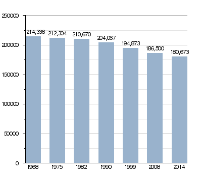
In 2014, Haute-Marne had a population of 180,673 people. This means there were about 29.1 people living in each square kilometer. The arrondissement of Saint-Dizier had the most people, with 71,371 residents.
Evolution of the population in Haute-Marne
Here are the communes (towns and villages) in Haute-Marne with the most people:
| City | Population (2014) |
Arrondissement |
|---|---|---|
| Saint-Dizier | 25,505 | Saint-Dizier |
| Chaumont | 22,560 | Chaumont |
| Langres | 7,877 | Langres |
| Nogent | 3,865 | Chaumont |
| Joinville | 3,407 | Saint-Dizier |
| Wassy | 2,893 | Saint-Dizier |
| Chalindrey | 2,437 | Langres |
| La Porte du Der | 2,335 | Saint-Dizier |
| Eurville-Bienville | 2,134 | Saint-Dizier |
| Bourbonne-les-Bains | 2,106 | Langres |
| Éclaron-Braucourt-Sainte-Livière | 2,083 | Saint-Dizier |
Gallery
-
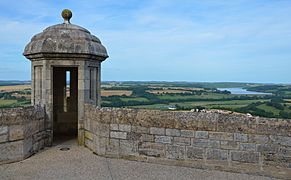
View from the walls of Langres
-
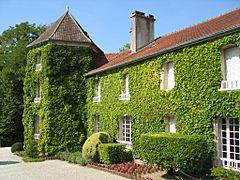
De Gaulle's house in Colombey-les-Deux-Églises
-
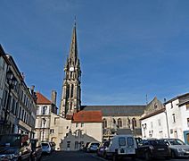
Joinville
-
Château of Cirey-sur-Blaise


.jpg)

Related pages
Images for kids
-

Frankish sword discovered in Saint-Dizier

See also
 In Spanish: Alto Marne para niños
