Arrondissement of Langres facts for kids
Quick facts for kids
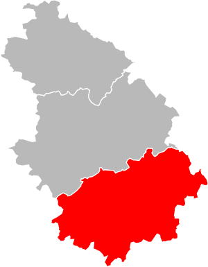
Arrondissement of Langres
|
|
|---|---|

Langres in Haute-Marne
|
|
| Country | France |
| Region | Grand Est |
| Department | Haute-Marne |
| Communes | 157 |
| Subprefecture | Langres |
| INSEE code | 522 |
| Area | |
| • Total | 2,162.9 km2 (835.1 sq mi) |
| Population
(2014)
|
|
| • Total | 44,332 |
| • Density | 20.4966/km2 (53.0858/sq mi) |
The Langres Arrondissement is a special area in France. It's like a district within the Haute-Marne department, which is part of the Grand Est region. Think of it as a smaller division of a larger area. The main city and capital of this arrondissement is Langres.
Contents
History of Langres Arrondissement
The Langres Arrondissement has been around for a long time. It was created in 1800. This was when the Haute-Marne department was first formed in France. So, it's one of the original parts of that department.
Geography of Langres Arrondissement
The Langres Arrondissement is located in the southern part of the Haute-Marne department. It shares borders with other areas. To the north, it's next to the Chaumont Arrondissement. To the northeast, it borders the Vosges department. The Haute-Saône department is to its southeast. Finally, to the south and west, it touches the Côte-d'Or department.
This arrondissement is the second largest in the Haute-Marne department. It covers an area of about 2,163 square kilometers (835 square miles). Even though it's big, it has the fewest people. In 2014, about 44,332 people lived there. This means its population density is about 20.5 people per square kilometer. This is how many people live in a certain amount of space.
How Langres Arrondissement is Organized
The Langres Arrondissement is made up of smaller parts. These parts help manage the area.
Cantons in Langres Arrondissement
Cantons are like smaller administrative areas. They are not always fully inside one arrondissement. In the Langres Arrondissement, there are five cantons. Two of these cantons also include towns that are in other arrondissements.
- Bourbonne-les-Bains (partly)
- Chalindrey
- Langres
- Nogent (partly)
- Villegusien-le-Lac
Communes in Langres Arrondissement
A "commune" is the smallest administrative division in France. It's like a town or a village. The Langres Arrondissement has 157 communes in total.
Here are some of the communes with the most people living in them:
| INSEE code |
Commune | Population (2014) |
Canton | Intercommunality |
|---|---|---|---|---|
| 52269 | Langres | 7,850 | Langres | Le Grand Langres |
| 52093 | Chalindrey | 2,437 | Chalindrey | Le Pays de Chalindrey, de Vannier Amance et de la région de Bourbonne-les-Bains |
| 52060 | Bourbonne-les-Bains | 2,106 | Bourbonne-les-Bains | Le Pays de Chalindrey, de Vannier Amance et de la région de Bourbonne-les-Bains |
| 52332 | Val-de-Meuse | 1,909 | Bourbonne-les-Bains | Le Grand Langres |
| 52432 | Rolampont | 1,522 | Nogent | Le Grand Langres |
| 52197 | Fayl-Billot | 1,356 | Chalindrey | Le Pays de Chalindrey, de Vannier Amance et de la région de Bourbonne-les-Bains |
| 52405 | Le Montsaugeonnais | 1,258 | Villegusien-le-Lac | Auberive Vingeanne et Montsaugeonnais |
| 52449 | Saints-Geosmes | 1,145 | Langres | Le Grand Langres |
| 52529 | Villegusien-le-Lac | 1,000 | Villegusien-le-Lac | Auberive Vingeanne et Montsaugeonnais |
| 52242 | Haute-Amance | 935 | Chalindrey | Le Pays de Chalindrey, de Vannier Amance et de la région de Bourbonne-les-Bains |
Related pages
See also
 In Spanish: Distrito de Langres para niños
 | Aurelia Browder |
 | Nannie Helen Burroughs |
 | Michelle Alexander |

