
Marne facts for kids
Quick facts for kids
Marne
|
|||
|---|---|---|---|
.jpg)
Prefecture building of the Marne department, in Châlons-en-Champagne
|
|||
|
|||

Location of Marne in France
|
|||
| Country | France | ||
| Region | Grand Est | ||
| Département | 4 March 1790 | ||
| Prefecture | Châlons-en-Champagne | ||
| Subprefectures | Épernay, Reims, Sainte-Menehould, Vitry-le-François | ||
| Area | |||
| • Total | 8,161.6 km2 (3,151.2 sq mi) | ||
| Population
(2013)
|
|||
| • Total | 569,999 | ||
| • Density | 69.8391/km2 (180.8825/sq mi) | ||
| Time zone | UTC+1 (CET) | ||
| • Summer (DST) | UTC+2 (CEST) | ||
| ISO 3166 code | FR-51 | ||
| Arrondissements | 5 | ||
| Cantons | 23 | ||
| Communes | 617 | ||


Marne is a department in northeastern France. It is named after the Marne river, which flows through the area. The main city and capital of Marne is Châlons-en-Champagne. This city used to be called Châlons-sur-Marne.
The Marne department is famous for its Champagne vineyards. These vineyards produce the world-famous sparkling wine known as Champagne.
Contents
History of Marne Department
How Marne Was Created
Marne was one of the first 83 departments created in France. This happened during the French Revolution on March 4, 1790. Its first capital was Châlons-sur-Marne. The department was formed from a part of the old province of Champagne.
Changes in Districts and Arrondissements
When it was first created, Marne was divided into six smaller areas called districts. These were Châlons-sur-Marne, Reims, Épernay, Sézanne, Sainte-Menehould, and Vitry-le-François.
In 1800, France created new administrative areas called arrondissements. The six districts in Marne were changed into five arrondissements: Châlons-sur-Marne, Épernay, Reims, Sainte-Menehould, and Vitry-le-François.
Marne After the Battle of Waterloo
After the Battle of Waterloo on June 18, 1815, the department was taken over by the Austrian army. They stayed in Marne from June 1815 until November 1818.
Changes to Sainte-Menehould and Châlons-en-Champagne
On September 10, 1926, the arrondissement of Sainte-Menehould was removed. However, in 1940, Sainte-Menehould became an arrondissement again.
In 1995, the name of Châlons-sur-Marne was changed to Châlons-en-Champagne. This change was first rejected in 1997 but was finally accepted in 1998.
Geography of Marne
The Marne department is located in the Grand Est region of France. Before 2016, it was part of the Champagne-Ardenne region. Marne shares its borders with three other regions and six different departments:
- Grand Est region:
* Ardennes department (to the north) * Meuse department (to the east) * Haute-Marne department (to the southeast) * Aube department (to the south)
- Île-de-France region:
* Seine-et-Marne department (to the southwest)
- Hauts-de-France region:
* Aisne department (to the west)
 |
Ardennes | |
||
| Aisne | Meuse | |||
| Seine-et-Marne | Aube | Haute-Marne |
Marne covers an area of about 8,161.6 square kilometers (3,151.2 square miles). This makes it the 7th largest department in Metropolitan France. The department is about 116 kilometers (72 miles) long from Villeneuve-la-Lionne to Trois-Fontaines-l'Abbaye. It is also about 97 kilometers (60 miles) wide from Cormicy to Clesles.

Geographic Regions of Marne
The Marne department has three main geographic areas:
- The Champagne crayeuse is in the center of the department. It is a plain where many cereals are grown.
- There is a region with low hills in the eastern part of the department.
- The Champagne vineyards are in the western part of the department. This area includes the Montagne de Reims ("Mountain of Reims"). The highest points in the department are found here, in the forests of the Verzey commune. Several hills reach about 286 meters (938 feet) high.
The Marne river flows through the department. It enters from the southeast and flows towards the west.
Climate in Marne
The climate in Marne usually has mild temperatures without extreme heat or cold. The climate type for Châlons-en-Champagne is called a "Marine West Coast Climate" (Cfb).
On average, Châlons-en-Champagne receives about 627.4 millimeters (24.7 inches) of precipitation each year. July is usually the wettest month, with about 61 millimeters (2.4 inches) of rain. February is typically the driest month, with an average of 40.6 millimeters (1.6 inches) of precipitation.
The average yearly temperature in Châlons-en-Champagne is about 10°C (50°F). July is the warmest month, with an average temperature of 20°C (68°F). January is the coolest month, with an average temperature of 0°C (32°F).
Administration of Marne
The Marne department is managed by the General Council of Marne. This council is located in Châlons-en-Champagne. The department is part of the Grand Est region.
Administrative Divisions
Marne is divided into 5 arrondissements (districts), 23 cantons, and 617 communes (municipalities).
| INSEE code |
Arrondissement | Capital | Population (2013) |
Area (km²) |
Density (Inh./km²) |
Communes |
|---|---|---|---|---|---|---|
| 511 | Châlons-en-Champagne | Châlons-en-Champagne | 102,735 | 1,778.3 | 57.8 | 100 |
| 512 | Épernay | Épernay | 110,098 | 2,332.7 | 47.2 | 181 |
| 513 | Reims | Reims | 295,406 | 1,525.7 | 193.6 | 156 |
| 514 | Vitry-le-François | Vitry-le-François | 47,854 | 1,503.6 | 31.8 | 113 |
| 515 | Sainte-Menehould | Sainte-Menehould | 13,906 | 1,021.3 | 13.6 | 67 |
Here is a list of the 23 cantons in the Marne department. These were reorganized in March 2015:
- Argonne Suippe et Vesle
- Bourgogne
- Châlons-en-Champagne-1
- Châlons-en-Champagne-2
- Châlons-en-Champagne-3
- Dormans-Paysages de Champagne
- Épernay-1
- Épernay-2
- Fismes-Montagne de Reims
- Mourmelon-Vesle et Monts de Champagne
- Reims-1
- Reims-2
- Reims-3
- Reims-4
- Reims-5
- Reims-6
- Reims-7
- Reims-8
- Reims-9
- Sermaize-les-Bains
- Sézanne-Brie et Champagne
- Vertus-Plaine Champenoise
- Vitry-le-François-Champagne et Der
Images for kids
-
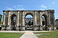
The Porte Mars in Reims, an ancient Roman arch.
-
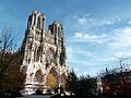
The famous Cathedral of Reims.
-
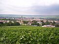
Vineyards near Epernay, where Champagne is made.
-
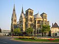
Notre-Dame-en-Vaux church in Châlons-en-Champagne.
-
The Valmy Battlefield, an important historical site.
_(9292412785).jpg)


Related Pages
See also
 In Spanish: Marne (desambiguación) para niños
