
Ardennes (department) facts for kids
Quick facts for kids
Ardennes
|
|||
|---|---|---|---|

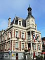
Prefecture building of the Ardennes department, in Charleville-Mézières
|
|||
|
|||

Location of Ardennes in France
|
|||
| Country | France | ||
| Region | Grand Est | ||
| Département | 4 March 1790 | ||
| Prefecture | Charleville-Mézières | ||
| Subprefectures | Rethel, Sedan, Vouziers | ||
| Area | |||
| • Total | 5,229.4 km2 (2,019.1 sq mi) | ||
| Population
(2014)
|
|||
| • Total | 279,715 | ||
| • Density | 53.4889/km2 (138.5357/sq mi) | ||
| Demonym(s) | Ardennais | ||
| Time zone | UTC+1 (CET) | ||
| • Summer (DST) | UTC+2 (CEST) | ||
| ISO 3166 code | FR-08 | ||
| Arrondissements | 4 | ||
| Cantons | 19 | ||
| Communes | 452 | ||
| Website | www.cd08.fr | ||


Ardennes is a special area in northeastern France called a department. It's part of the Grand Est region. This department is named after the famous Ardennes forest. The main city, or "prefecture," of Ardennes is Charleville-Mézières.
Contents
History of Ardennes
The Ardennes department was created a long time ago, on March 4, 1790. This happened during the French Revolution. It was one of the first 83 departments ever made in France.
Its first capital city was Mézières. The department was formed from parts of older areas. These included the Champagne province and the areas around Sedan and Argonne.
Changes Over Time
At first, Ardennes was divided into six smaller areas called districts. These were Charleville, Grandpré, Rethel, Rocroi, Sedan, and Vouziers.
Later, in 1800, these districts were changed. They became five "arrondissements" (which are like administrative districts). These new arrondissements were Mézières, Rethel, Rocroi, Sedan, and Vouziers.
Over the years, some changes happened. In 1926, the Rocroi and Sedan arrondissements were removed. But in 1942, Sedan became an arrondissement again.
Finally, the towns of Charleville and Mézières joined together. They formed one new town called Charleville-Mézières. This new, bigger city became the capital of the department.
Geography of Ardennes
Ardennes is located in the Grand Est region of France. It covers an area of about 5,229.4 square kilometers (2,019.1 square miles).
Borders and Neighbors
The department shares a border with Belgium to the north. Specifically, it touches the Namur and Luxembourg provinces of Belgium.
It also borders three other departments in France:
- In the Hauts-de-France region:
* Aisne (to the west)
- In the Grand Est region:
* Marne (to the south) * Meuse (to the east)
 |
Namur province (Belgium) | Luxembourg province (Belgium) | |
|
| Aisne | Meuse | |||
| Marne |
Highest and Lowest Points
The highest point in Ardennes is a place called Croix-Scaille. It's about 500 to 505 meters (1,640 to 1,657 feet) high. You can find it between the French town of Hautes-Rivières and the Belgian town of Gedinne.
The lowest point is along the Aisne river, in the town of Brienne-sur-Aisne. This spot is about 57 meters (187 feet) high.
Rivers in Ardennes
Several rivers flow through the Ardennes department. The two most important rivers are the Meuse, which flows through the northern part, and the Aisne, which is in the south.
Climate of Ardennes
The climate in Charleville-Mézières is an "Oceanic climate." This means it has mild temperatures and rainfall throughout the year.
- The average yearly rainfall in Charleville-Mézières is about 703.6 millimeters (27.7 inches).
- November usually gets the most rain, with about 86.4 mm (3.4 inches).
- June is often the driest month, with about 38.1 mm (1.5 inches) of rain.
The average temperature for the year in Charleville-Mézières is 9.9°C (49.8°F).
- July is usually the warmest month, with an average temperature of 18.1°C (64.6°F).
- January is typically the coolest month, with an average temperature of 2.3°C (36.1°F).
| Climate data for Charleville-Mézières, France | |||||||||||||
|---|---|---|---|---|---|---|---|---|---|---|---|---|---|
| Month | Jan | Feb | Mar | Apr | May | Jun | Jul | Aug | Sep | Oct | Nov | Dec | Year |
| Mean daily maximum °C (°F) | 5.1 (41.2) |
6.6 (43.9) |
10.8 (51.4) |
14.6 (58.3) |
18.8 (65.8) |
21.6 (70.9) |
24.1 (75.4) |
23.7 (74.7) |
19.6 (67.3) |
14.9 (58.8) |
9.1 (48.4) |
5.7 (42.3) |
14.6 (58.2) |
| Daily mean °C (°F) | 2.3 (36.1) |
3.0 (37.4) |
6.2 (43.2) |
9.0 (48.2) |
13.1 (55.6) |
15.9 (60.6) |
18.1 (64.6) |
17.7 (63.9) |
14.3 (57.7) |
10.6 (51.1) |
5.9 (42.6) |
3.1 (37.6) |
9.9 (49.9) |
| Mean daily minimum °C (°F) | −0.5 (31.1) |
−0.7 (30.7) |
1.6 (34.9) |
3.3 (37.9) |
7.3 (45.1) |
10.2 (50.4) |
12.1 (53.8) |
11.7 (53.1) |
8.9 (48.0) |
6.2 (43.2) |
2.7 (36.9) |
0.5 (32.9) |
5.3 (41.5) |
| Average rainfall mm (inches) | 68 (2.7) |
51.9 (2.04) |
46.9 (1.85) |
58.9 (2.32) |
50.9 (2.00) |
38.7 (1.52) |
41.8 (1.65) |
37.1 (1.46) |
56.8 (2.24) |
80.7 (3.18) |
87.4 (3.44) |
83.7 (3.30) |
702.8 (27.7) |
| Source: Weatherbase.com [1] | |||||||||||||
Administration of Ardennes
The Ardennes department is run by the Departmental Council of Ardennes. This council is located in Charleville-Mézières, the main city. The department is part of the larger Grand Est region.
Administrative Divisions
Ardennes is divided into smaller parts to help with its management.
- There are 4 main arrondissements (which are like large districts).
- These are further divided into 19 cantons (smaller voting and administrative areas).
- Finally, there are 452 communes (which are like local towns or municipalities).
| INSEE code |
Arrondissement | Capital | Population (2014) |
Area (km²) |
Density (inh./km²) |
Communes |
|---|---|---|---|---|---|---|
| 081 | Charleville-Mézières | Charleville-Mézières | 160,939 | 1,825.3 | 88.2 | 160 |
| 082 | Rethel | Rethel | 37,142 | 1,199.7 | 31.0 | 101 |
| 083 | Sedan | Sedan | 59,584 | 792.2 | 75.2 | 73 |
| 084 | Vouziers | Vouziers | 22,050 | 1,412.2 | 15.6 | 118 |
Here is a list of the 19 cantons in the Ardennes department. These were reorganized in March 2015:
- Attigny (0801)
- Bogny-sur-Meuse (0802)
- Carignan (0803)
- Charleville-Mézières-1 (0804)
- Charleville-Mézières-2 (0805)
- Charleville-Mézières-3 (0806)
- Charleville-Mézières-4 (0807)
- Château-Porcien (0808)
- Givet (0809)
- Nouvion-sur-Meuse (0810)
- Rethel (0811)
- Revin (0812)
- Rocroi (0813)
- Sedan-1 (0814)
- Sedan-2 (0815)
- Sedan-3 (0816)
- Signy-l'Abbaye (0817)
- Villers-Semeuse (0818)
- Vouziers (0819)
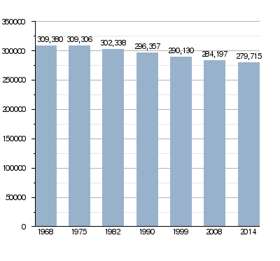
Population of Ardennes
The people who live in the Ardennes department are called Ardennais in French. If they are women, they are called Ardennaises.
In 2014, Ardennes had a population of 279,715 people. This means there were about 53.5 people living per square kilometer. The arrondissement of Charleville-Mézières had the most people, with 160,939 residents.
How the population of Ardennes has changed
Main Towns in Ardennes
Here are the main towns (communes) in the Ardennes department:
| City | Population (2014) |
Arrondissement |
|---|---|---|
| Charleville-Mézières | 48,615 | Charleville-Mézières |
| Sedan | 17,829 | Sedan |
| Rethel | 7,778 | Rethel |
| Givet | 6,659 | Charleville-Mézières |
| Revin | 6,586 | Charleville-Mézières |
| Nouzonville | 6,107 | Charleville-Mézières |
| Bogny-sur-Meuse | 5,222 | Charleville-Mézières |
Gallery
-
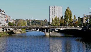
Charleville-Mézières on the Meuse.
-
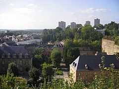
Sedan, the second largest urban area of Ardennes.
-
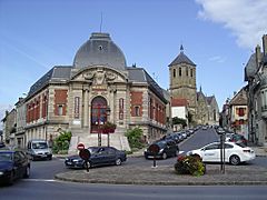
Rethel, the third largest city of Ardennes.


Related pages
Images for kids
-
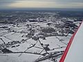
Rocroi in the snow – shallow to deep snow in winter is likely in this department.
-
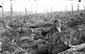
Forest of Argonne in October 1915 ravaged by shellfire.
-
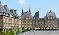
Place Ducale in Charleville-Mézières, prefecture of the Ardennes department.
-
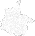
Map of the communes of the Ardennes department.
-
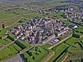
The small town of Rocroi was a sub-prefecture of Ardennes until 1926.
-
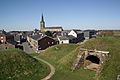
The Hotel de Ville in Givet, a border town with Belgium.
-
Monthermé along the Meuse
-
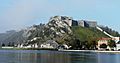
Fort de Charlemont in Givet
-
The citadel of Rocroi
-
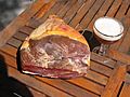
Dry-cured ham from Ardennes
-
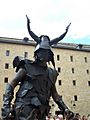
Medieval Festival in 2011
-
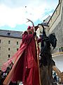
Medieval Festival in 2011
-
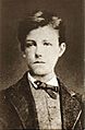
Arthur Rimbaud was a native of Charleville-Mézières.
-
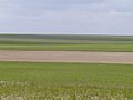
A typical landscape of Champagne chalk in the south of the department.
-
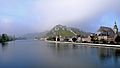
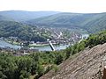
View of the Meuse valley in the north of the department at Givet.
-
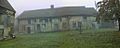
Farm of Porcien in the south-west of the department.


See also
 In Spanish: Ardenas para niños
