
Aisne facts for kids
Quick facts for kids
Aisne
|
|||
|---|---|---|---|

Town hall of Laon, Aisne
|
|||
|
|||

Location of Aisne in France
|
|||
| Country | France | ||
| Region | Hauts-de-France | ||
| Département | 4 March 1790 | ||
| Prefecture | Laon | ||
| Subprefectures | Château-Thierry, Saint-Quentin, Soissons, Vervins | ||
| Area | |||
| • Total | 7,369.1 km2 (2,845.2 sq mi) | ||
| Population
(2014)
|
|||
| • Total | 539,783 | ||
| • Density | 73.2495/km2 (189.7154/sq mi) | ||
| Demonym(s) | Axonais | ||
| Time zone | UTC+1 (CET) | ||
| • Summer (DST) | UTC+2 (CEST) | ||
| ISO 3166 code | FR-02 | ||
| Arrondissements | 5 | ||
| Cantons | 21 | ||
| Communes | 804 | ||
| Website | http://www.aisne.com | ||


Aisne is a special area in the north of France. It's called a "department." It's part of the Hauts-de-France region. The department gets its name from the Aisne River, which flows into another river called the Oise. The main city and government center of Aisne is Laon.
Contents
History of Aisne
Aisne is one of the first 83 departments ever created in France. This happened during the French Revolution on March 4, 1790. Laon was chosen as its capital city.
The department was formed from parts of older French regions. These included Île-de-France, Picardy, and Champagne.
At first, Aisne was divided into six smaller areas called "districts." Later, in 1800, these districts were changed into five "arrondissements." An arrondissement is like a large administrative area.
One of these arrondissements, Château-Thierry, was removed in 1926. But it was brought back again in 1942.
Geography of Aisne
Aisne is located in the Hauts-de-France region of France. It covers an area of about 7,369 square kilometers (2,845 square miles).
The department shares its borders with Belgium and six other departments in France. These departments are in three different regions:
- Hauts-de-France region:
- Grand Est region:
- Île-de-France region:
- Seine-et-Marne (to the south)
 |
Somme | Nord | Belgium | |
| Oise | Ardennes | |||
| Seine-et-Marne | Marne |
The land in Aisne is mostly made up of low, flat areas called plateaus and small hills. The highest point in the department is a place called Le Chêne Nain. It is about 295 to 300 meters (968 to 984 feet) high. This spot is in the Ardennes forest, close to the border with the Ardennes department and Belgium.
The southern part of Aisne is known as la Brie poilleuse. This dry plateau is famous for its dairy products and Brie cheese.
Many rivers flow through Aisne. The most important ones include the Scheldt/Escaut, the Aisne, the Marne, the Ourcq, the Vesle, the Somme, the Oise, and the Serre.
Climate in Aisne
The climate in Laon, the main city, is an "Oceanic climate." This means it has mild temperatures and rain throughout the year.
On average, Laon gets about 571.5 millimeters (22.5 inches) of rain each year. July is usually the wettest month, with about 61 millimeters (2.4 inches) of rain. March is the driest month, with only about 30.5 millimeters (1.2 inches) of rain.
Laon also gets some snow, averaging about 17.8 centimeters (7 inches) per year. February is the snowiest month, with about 6.9 centimeters (2.7 inches) of snow.
The average temperature in Laon for the whole year is 9.4°C (48.9°F). July is the warmest month, with an average temperature of 17.2°C (63°F). January is the coolest month, with an average temperature of 1.7°C (35.1°F).
| Climate data for Laon, France | |||||||||||||
|---|---|---|---|---|---|---|---|---|---|---|---|---|---|
| Month | Jan | Feb | Mar | Apr | May | Jun | Jul | Aug | Sep | Oct | Nov | Dec | Year |
| Mean daily maximum °C (°F) | 4 (39) |
5 (41) |
11 (52) |
14 (57) |
17 (63) |
21 (70) |
22 (72) |
22 (72) |
20 (68) |
15 (59) |
8 (46) |
6 (43) |
14 (57) |
| Daily mean °C (°F) | 1 (34) |
2 (36) |
6 (43) |
9 (48) |
12 (54) |
15 (59) |
17 (63) |
17 (63) |
15 (59) |
10 (50) |
5 (41) |
3 (37) |
9 (49) |
| Mean daily minimum °C (°F) | −1 (30) |
−1 (30) |
1 (34) |
4 (39) |
7 (45) |
10 (50) |
12 (54) |
12 (54) |
10 (50) |
6 (43) |
2 (36) |
1 (34) |
5 (42) |
| Average rainfall mm (inches) | 40 (1.6) |
50 (2.0) |
20 (0.8) |
30 (1.2) |
40 (1.6) |
30 (1.2) |
50 (2.0) |
50 (2.0) |
50 (2.0) |
50 (2.0) |
40 (1.6) |
50 (2.0) |
500 (20) |
| Source: Weatherbase.com [1] | |||||||||||||
Administration of Aisne
Aisne is governed by the Departmental Council of Aisne. This council is based in Laon. The department is part of the Hauts-de-France region.
Administrative Divisions
Aisne is divided into several administrative parts. There are 5 main areas called arrondissements. Within these, there are 21 smaller areas called cantons. The smallest divisions are the 804 communes, which are like local towns or villages.
| Arrondissement | Capital | Population (2014) |
Area (km²) |
Density (People/km²) |
Communes |
|---|---|---|---|---|---|
| Château-Thierry | Château-Thierry | 73,188 | 1,193.2 | 61.3 | 108 |
| Laon | Laon | 165,489 | 2,461.3 | 67.2 | 244 |
| Saint-Quentin | Saint-Quentin | 130,918 | 1,071.2 | 122.2 | 126 |
| Soissons | Soissons | 103,840 | 1,242.8 | 83.6 | 166 |
| Vervins | Vervins | 66,348 | 1,400.6 | 47.4 | 160 |
Here is a list of the 21 cantons in the Aisne department. These were reorganized in March 2015:
- Bohain-en-Vermandois
- Château-Thierry
- Chauny
- Essômes-sur-Marne
- Fère-en-Tardenois
- Guignicourt
- Guise
- Hirson
- Laon-1
- Laon-2
- Marle
- Ribemont
- Saint-Quentin-1
- Saint-Quentin-2
- Saint-Quentin-3
- Soissons-1
- Soissons-2
- Tergnier
- Vervins
- Vic-sur-Aisne
- Villers-Cotterêts
Demographics of Aisne
The people who live in Aisne are called Axonais in French. This name comes from the old Celtic name for the Aisne river, which was Axona.
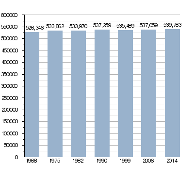
In 2014, Aisne had a population of 539,783 people. This means there were about 73.3 people living in each square kilometer (189.9 people per square mile). The arrondissement of Laon had the most people, with 165,489 residents.
Evolution of the population in Aisne
Here are the 10 communes (towns or villages) in Aisne with the most people:
| City | Population (2014) |
Arrondissement |
|---|---|---|
| Saint-Quentin | 55,878 | Saint-Quentin |
| Soissons | 28,290 | Soissons |
| Laon | 25,282 | Laon |
| Château-Thierry | 14,546 | Château-Thierry |
| Tergnier | 13,742 | Laon |
| Chauny | 11,897 | Laon |
| Villers-Cotterêts | 10,892 | Soissons |
| Hirson | 9,336 | Vervins |
| Bohain-en-Vermandois | 5,659 | Saint-Quentin |
| Gauchy | 5,343 | Saint-Quentin |
Gallery


Related pages
Images for kids
-
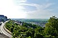
The Aisne department at Laon, 2018
-
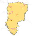
The main cities of the department
-
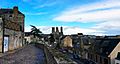
Laon and its cathedral, 2019
-
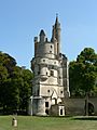
The keep of the castle of Septmonts
-
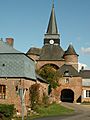
Fortified church of Parfondeval
-
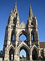
Ruins of the Abbey of St. Jean des Vignes in Soissons


See also
 In Spanish: Aisne para niños
