
Nord (department) facts for kids
Quick facts for kids
Nord
|
|||
|---|---|---|---|

Prefecture building of the Nord department, in Lille.
|
|||
|
|||

Location of Nord in France
|
|||
| Country | France | ||
| Region | Hauts-de-France | ||
| Département | 4 March 1790 | ||
| Prefecture | Lille | ||
| Subprefectures | Avesnes-sur-Helpe, Cambrai, Douai, Dunkirk, Valenciennes | ||
| Area | |||
| • Total | 5,742.8 km2 (2,217.3 sq mi) | ||
| Population
(2014)
|
|||
| • Total | 2,603,472 | ||
| • Density | 453.345/km2 (1,174.159/sq mi) | ||
| Demonym(s) | Nordistes | ||
| Time zone | UTC+1 (CET) | ||
| • Summer (DST) | UTC+2 (CEST) | ||
| ISO 3166 code | FR-59 | ||
| Arrondissements | 6 | ||
| Cantons | 41 | ||
| Communes | 648 | ||


Nord is a department in the very north of France. It's called 'Nord' because that means 'North' in French, and it's right at the top of the country! The main city and capital of Nord is Lille.
Contents
History of Nord
Nord is one of the first 83 departments created in France. This happened during the French Revolution on March 4, 1790. Back then, Douai was its first capital city.
The department was first split into eight smaller areas called districts. Later, in 1800, these districts were changed into six arrondissements, which are like bigger administrative zones.
A few years later, in 1803, the capital of Nord moved from Douai to Lille. This made Lille the most important city in the department. Over time, some of the arrondissements changed their names or were combined. For example, the arrondissement of Valenciennes was created in 1824.
Geography of Nord
Nord is part of the Hauts-de-France region in northern France. It covers an area of about 5,743 square kilometers (2,217 square miles).
The department has some interesting neighbors! To the north, it touches the North Sea and Belgium. To the south, it borders the Aisne department. To the southwest, it has a short border with the Somme department. And to the west, it's next to the Pas-de-Calais department.
 |
North Sea | Belgium | |
|
| Pas-de-Calais | Belgium | |||
| Somme | Aisne |
The highest point in Nord is in a town called Anor. It's about 271 meters (889 feet) high, which is like climbing a very tall building! Several rivers flow through Nord, including the Scheldt, Yser, Lys, Scarpe, and Sambre. These rivers are important for the region's landscape and history.
Climate in Nord
The climate in Nord is known as an "Oceanic climate". This means it's similar to the weather you might find near an ocean, with mild temperatures and rain throughout the year.
In Lille, the average rainfall for the year is about 645 millimeters (25.4 inches). October usually gets the most rain, while February is the driest month.
The average temperature in Lille for the whole year is about 10.8°C (51.4°F). July is usually the warmest month, with temperatures around 18.6°C (65.5°F). January is the coolest, with an average temperature of 3.6°C (38.5°F).
| Climate data for Lille, France | |||||||||||||
|---|---|---|---|---|---|---|---|---|---|---|---|---|---|
| Month | Jan | Feb | Mar | Apr | May | Jun | Jul | Aug | Sep | Oct | Nov | Dec | Year |
| Mean daily maximum °C (°F) | 6.0 (42.8) |
6.9 (44.4) |
10.6 (51.1) |
14.1 (57.4) |
17.9 (64.2) |
20.6 (69.1) |
23.3 (73.9) |
23.3 (73.9) |
19.7 (67.5) |
15.2 (59.4) |
9.8 (49.6) |
6.4 (43.5) |
14.5 (58.1) |
| Daily mean °C (°F) | 3.6 (38.5) |
4.1 (39.4) |
7.1 (44.8) |
9.8 (49.6) |
13.4 (56.1) |
16.2 (61.2) |
18.6 (65.5) |
18.5 (65.3) |
15.5 (59.9) |
11.7 (53.1) |
7.1 (44.8) |
4.2 (39.6) |
10.8 (51.5) |
| Mean daily minimum °C (°F) | 1.2 (34.2) |
1.3 (34.3) |
3.6 (38.5) |
5.4 (41.7) |
8.9 (48.0) |
11.7 (53.1) |
13.8 (56.8) |
13.6 (56.5) |
11.2 (52.2) |
8.1 (46.6) |
4.4 (39.9) |
1.9 (35.4) |
7.1 (44.8) |
| Average rainfall mm (inches) | 40 (1.6) |
40 (1.6) |
40 (1.6) |
40 (1.6) |
50 (2.0) |
50 (2.0) |
60 (2.4) |
50 (2.0) |
50 (2.0) |
60 (2.4) |
60 (2.4) |
50 (2.0) |
590 (23.6) |
| Source: Weatherbase.com [1] | |||||||||||||
How Nord is Governed
Nord is managed by the Departmental Council of Aisne in Lille. This council helps make decisions for the department and is part of the larger Hauts-de-France region's government.
Administrative Divisions
Nord is divided into several administrative areas to help manage it. There are 6 main arrondissements (like large districts), 41 cantons (smaller areas for elections), and 648 communes (individual towns and villages).
| INSEE code |
Arrondissement | Capital | Population (2014) |
Area (km²) |
Density (Inh./km²) |
Communes |
|---|---|---|---|---|---|---|
| 591 | Avesnes-sur-Helpe | Avesnes-sur-Helpe | 231,727 | 1,407.5 | 164.6 | 151 |
| 592 | Cambrai | Cambrai | 163,065 | 901.6 | 180.9 | 116 |
| 593 | Douai | Douai | 246,595 | 476.6 | 517.4 | 64 |
| 594 | Dunkirk | Dunkirk | 378,499 | 1,442.7 | 262.4 | 111 |
| 595 | Lille | Lille | 1,232,513 | 879.5 | 1,401.4 | 124 |
| 596 | Valenciennes | Valenciennes | 351,073 | 634.8 | 553.0 | 82 |
People of Nord
The people who live in Nord are called Nordistes in French. In 2014, Nord had a population of over 2.6 million people. This means it's a very populated area, with many people living close together.
The arrondissement of Lille is the most populated area within Nord. It has over 1.2 million inhabitants!
Here are the 10 largest towns and cities in Nord, based on their population in 2014:
| City | Population (2014) |
Arrondissement |
|---|---|---|
| Lille | 233,897 | Lille |
| Roubaix | 95,600 | Lille |
| Tourcoing | 95,329 | Lille |
| Dunkirk | 89,160 | Dunkirk |
| Villeneuve d'Ascq | 62,869 | Lille |
| Valenciennes | 43,787 | Valenciennes |
| Wattrelos | 41,337 | Lille |
| Douai | 40,736 | Douai |
| Marcq-en-Barœul | 39,291 | Lille |
| Cambrai | 32,897 | Cambrai |
Images for kids
-
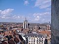
Overview of Douai.
-
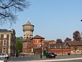
Place Verte, Valenciennes.


.JPG)


