
Cambrai facts for kids
Quick facts for kids
Cambrai
|
|||
|---|---|---|---|
|
Subprefecture and commune
|
|||
![The bell tower of the town hall, where Martin and Martine [fr] mark the hours](/Image:Campanile_h%C3%B4tel_de_ville_Cambrai.JPG)
The bell tower of the town hall, where Martin and Martine mark the hours
|
|||
|
|||

Cambrai
Location in France

Cambrai
Location in Hauts-de-France
|
|||
| Country | France | ||
| Region | Hauts-de-France | ||
| Department | Nord | ||
| Arrondissement | Cambrai | ||
| Canton | Cambrai | ||
| Intercommunality | CA de Cambrai | ||
| Area
1
|
18.12 km2 (7.00 sq mi) | ||
| Population
(2021)
|
31,425 | ||
| • Density | 1,734.3/km2 (4,491.7/sq mi) | ||
| Demonym(s) | Cambrésiens | ||
| Time zone | UTC+01:00 (CET) | ||
| • Summer (DST) | UTC+02:00 (CEST) | ||
| INSEE/Postal code |
59122 /59400
|
||
| Elevation | 41–101 m (135–331 ft) (avg. 60 m or 200 ft) |
||
| 1 French Land Register data, which excludes lakes, ponds, glaciers > 1 km2 (0.386 sq mi or 247 acres) and river estuaries. | |||

Cambrai is a historic city in the Nord area of France. It sits right on the Scheldt river, which locals call the Escaut.
Cambrai is a "sub-prefecture," meaning it's an important administrative center for its region. In 2018, about 32,501 people lived here. It's part of a larger urban area with over 94,000 residents. It's also connected to the big Lille metropolitan area, which has more than 3.8 million people.
Long ago, during the Roman Empire, Cambrai became the main city for the Nervii people. Later, it grew into a powerful church center, ruled by bishops who had both religious and some political power. This lasted until France took control in 1678.
In the Middle Ages, Cambrai became rich thanks to its fertile lands and its textile industry, especially weaving. However, in more recent times, it hasn't been as industrial as some of its neighbors.
Cambrai played a big role in both World Wars. During World War I, it was the site of the Battle of Cambrai in 1917. This battle is famous because it was one of the first times tanks were used in a big way. The city was badly damaged during the wars but was rebuilt.
Today, Cambrai is a lively city. It has kept many of its old buildings and traditions, even after all the destruction. It's an important hub for the surrounding area, known as Cambrésis. Its location on major roads and a river helps its economy.
Contents
- History of Cambrai
- Geography of Cambrai
- Getting Around Cambrai
- City Layout and Housing
- Economy of Cambrai
- Local Culture and Heritage
- Famous People from Cambrai
- Images for kids
- See also
History of Cambrai
Ancient Times
Not much is known about Cambrai's very first days. The Romans called it Camaracum. It first appeared on old maps around the mid-300s. It became the main town for the Roman province of the Nervii, taking over from an earlier capital called Bavay.
Around the same time, Frankish groups from the north started attacking. This made the Romans build forts along important roads, and Cambrai became a key defense spot. In 430, the Salian Franks, led by Clodio, took control of the town. Later, in 509, Clovis I united the Frankish kingdoms.
The Middle Ages
Cambrai started to grow from a small market town into a real city during the Merovingian period. This was a peaceful time. The areas of Arras and Cambrai were joined under one bishop. Cambrai became an important administrative center. Bishops like Gaugericus built churches and abbeys. These places housed important religious items, which helped Cambrai become a true city.

In 843, Charlemagne's empire was split into three parts by the Treaty of Verdun. Cambrai ended up in the kingdom of Lothair I. Later, in 870, the town was destroyed by the Normans.

In the Middle Ages, the area around Cambrai was a county. The local count and the bishop often argued over who had power. In 948, Emperor Otto I gave the bishop power over the city. In 1007, Emperor Henry II extended this power to the surrounding land. This made Cambrai a church principality, like a small independent state within the Holy Roman Empire.
In 958, the people of Cambrai rebelled against the bishop. This was one of the first "communal uprisings" in Europe, where citizens fought for more freedom. The rebellion was stopped, but people kept fighting for their rights for centuries. By 1227, the citizens finally had to accept the bishop's rule. However, they still kept some freedoms in how their town was managed.
Cambrai is also known for an old Irish religious text called the Cambrai Homily.
Growing Economy
.jpg)
During the Middle Ages, Cambrai became richer and larger. This was thanks to its weaving industry, which made wool, linen, and a fine cloth called cambric. The city was part of a trade group of seventeen cities. This group helped develop trade with big markets in other parts of France. By the 11th century, the city walls were built to a size they would keep for many centuries.
Musical History

Cambrai has a special musical history, especially in the 1400s. The old cathedral was a major music center. Many famous composers of the Burgundian School either grew up there or came back to teach. In 1428, someone even said the cathedral had the best singing, light, and bells in all of Christianity!
Guillaume Dufay, one of the most famous European musicians of the 1400s, studied at the cathedral from 1409 to 1412. He returned in 1439 after living in Italy. Other famous composers like Johannes Tinctoris and Ockeghem also came to Cambrai to learn from Dufay.
Hundred Years' War Impact
The bishop tried to keep Cambrai independent. But it was hard because the county was stuck between powerful neighbors like Flanders, Hainaut, and France. During the Hundred Years' War, in 1339, the English king Edward III tried to capture the city but had to leave.
Later, John of Burgundy, an illegitimate son of John the Fearless, became bishop. It looked like Burgundy might take over Cambrai. But when Charles the Bold died suddenly in 1477, Louis XI of France quickly took control of Cambrai, though he left a year later.
The Legend of Martin and Martine
Martin and Martine are two legendary figures who are said to have saved Cambrai. There are different versions of their story. The most common one says that around 1370, a blacksmith named Martin, who was of Moorish descent, lived in Cambrai. He joined other citizens to fight a lord who was bothering the region.
Martin, using only his heavy iron hammer, faced the enemy. He hit the lord's helmet so hard that it pushed down to his eyes, blinding him. The lord quickly gave up. Today, automatons (moving figures) of Martin and Martine stand on top of the town hall. They strike the hours with a hammer, reminding everyone of Martin's powerful blow.
Early Modern Era

As trade shifted away from Bruges, the area around Cambrai became poorer. However, because Cambrai was neutral and located between the Habsburg Empire and France, it became a place for important international meetings. One such meeting led to the League of Cambrai in 1508. This was an alliance against Venice, but it later fell apart. Cambrai was also where the Paix des Dames (Ladies' Peace) was signed in 1529, ending a war for France.
In 1543, Charles V, Holy Roman Emperor conquered Cambrai. He ordered the old monastery of Saint-Sépulchre to be torn down and built a strong citadel in its place. In 1595, the Spanish took the city during the French Wars of Religion.
In 1623, a community of English Benedictine nuns was founded in Cambrai. They were forced to leave during the French Revolution but later re-established themselves in England.
France and Spain fought many wars in the 1600s. Cardinal Richelieu and Cardinal Mazarin both tried to gain control of Cambrai for France. The city was besieged many times.
Cambrai Joins France
In 1676, Louis XIV of France decided to secure his borders. His troops attacked Valenciennes and then moved towards Cambrai, which was a very strong city. On April 5, 1677, the city surrendered to the French. The Spanish soldiers retreated to the citadel, which surrendered on April 17. Louis XIV entered the city on April 19.
By the Treaty of Nijmegen in 1678, Spain officially gave Cambrai to France. It has been part of France ever since. French influence changed the city's architecture. The first archbishop appointed by the French king was François Fénelon. He was known as the "Swan of Cambrai" and worked hard to teach people about their faith.
The French Revolution
The city suffered a lot during the French Revolution. In 1794, a man named Joseph Le Bon was sent to Cambrai. He caused a lot of fear and sent many people to the guillotine. He was later tried and executed himself in 1795.
Most of the religious buildings in Cambrai were destroyed during this time. The beautiful old cathedral, once called the "wonder of the low countries," was sold in 1796. It was used as a stone quarry, and only its tower remained. That tower collapsed in a storm in 1809. Later, a new cathedral was built.
19th Century Changes

The Franco-Prussian War of 1870 mostly spared Cambrai. This war showed that the city's old fortifications were no longer useful. So, in 1892, the city got permission to tear them down. Wide boulevards were built where the walls once stood, from 1894 into the early 1900s. This completely changed the city's look and boosted its economy.
20th Century Challenges

In 1914, the German army occupied Cambrai. This occupation lasted four years and involved looting and arrests. From November 20 to December 17, 1917, the Battle of Cambrai took place nearby. This battle was famous for the first large-scale use of tanks.
In 1918, the Germans burned the city center before leaving. They destroyed the city hall and many archives. More than 1,500 buildings were completely ruined out of 3,500 in Cambrai. The city center had to be rebuilt.
World War II also hit Cambrai hard. The city was bombed by the Luftwaffe in May 1940. From April to August 1944, Allied air raids targeted railway tracks. These raids killed 250 people and destroyed 1,700 buildings, which was over half the city. American tanks entered Cambrai on September 2.
After the war, rebuilding was the top priority. New houses were built, and the city's population grew quickly. However, this growth slowed down after the 1973 oil crisis. The city lost many industrial jobs and shifted towards public services and other non-manufacturing jobs.
Geography of Cambrai
Location and Surroundings

Cambrai is in the southern part of the Nord Department in France. It's surrounded by other cities that are only a few dozen kilometers away. For example, Douai is 24 km away, Valenciennes is 29 km, and Lille, the regional capital, is 52 km from Cambrai.
The city is also not far from several European capitals. Brussels is 108 km away, Paris is 160 km, and London is 279 km.
Cambrai grew up on the right bank of the Scheldt river, known locally as the Escaut. This river starts just over 20 km away in the Aisne department.
 |
|
|||
Geology and Landforms

Cambrai is built on chalk rock from the Cretaceous period. This chalk forms the northern edge of the Paris Basin. Cambrai is in a lower area between the hills of Thiérache and Artois. This lower area, called the "Cambrai threshold," makes it easier to travel between the south and the north. Important canals and highways use this path.
The chalky ground allowed people to dig many cellars, tunnels, and quarries under the city. The local chalk was used for simple buildings or to make lime. For fancier buildings, stone from nearby villages was used.
The western, northern, and southern parts of the city are bordered by the flat, wet areas of the Scheldt Valley.
Rivers and Waterways

Cambrai is built on the right bank of the Scheldt river. Even though the river is small here, it was very important for the city's history. It allowed people and goods to be transported since ancient times.
The Scheldt also formed a border between different bishoprics and kingdoms. This made Cambrai part of the Holy Roman Empire until 1677.
The river was vital for many businesses like tanning leather, milling grain, and making soap. It was also used for "retting" linen, which was a main activity in the city. The river also helped defend the city in the Middle Ages and later.
Even though the Scheldt was so important, it's not a big part of the city's look today.
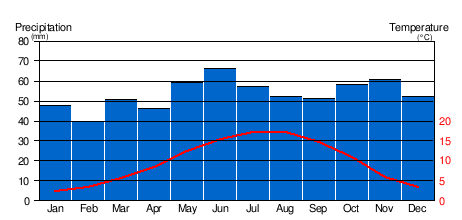
Climate Information
The climate in Cambrai has mild differences between high and low temperatures. There is enough rainfall all year round. It's an "Oceanic climate," but the city is about 110 km from the coast.
Rainfall is spread throughout the year, with more rain in spring and autumn. February is usually the driest month. The total yearly rainfall is relatively low, similar to Paris. However, Cambrai has more rainy days, confirming its oceanic climate.
The average temperature difference between winter and summer is not more than 15°C. Cambrai is generally 1.5 to 2°C colder than Paris. On average, there are 71 days of fog, 15 days of storms, and 20 days with snow each year.
Compared to coastal towns like Dunkirk, Cambrai has colder minimum temperatures and warmer maximum temperatures. This means it has a "transitional" oceanic climate, with some influences from inland areas.
The highest temperature ever recorded in Cambrai was 38.2°C on August 6, 2003.
| Climate data for Cambrai-Épinoy | |||||||||||||
|---|---|---|---|---|---|---|---|---|---|---|---|---|---|
| Month | Jan | Feb | Mar | Apr | May | Jun | Jul | Aug | Sep | Oct | Nov | Dec | Year |
| Mean daily maximum °C (°F) | 6 (42) |
7 (44) |
11 (51) |
14 (57) |
18 (64) |
21 (69) |
23 (73) |
23 (73) |
19 (67) |
14 (58) |
9 (48) |
5 (41) |
11 (52) |
| Daily mean °C (°F) | 2.5 (36.5) |
3.3 (37.9) |
5.8 (42.4) |
8.6 (47.5) |
12.4 (54.3) |
15.3 (59.5) |
17.3 (63.1) |
17.3 (63.1) |
14.8 (58.6) |
11.1 (52.0) |
6.0 (42.8) |
3.4 (38.1) |
9.8 (49.6) |
| Mean daily minimum °C (°F) | 0 (32) |
0 (32) |
2 (36) |
4 (40) |
8 (46) |
11 (51) |
13 (55) |
13 (55) |
11 (51) |
7 (44) |
3 (38) |
1 (33) |
6 (43) |
| Average precipitation mm (inches) | 46 (1.8) |
41 (1.6) |
53 (2.1) |
48 (1.9) |
46 (1.8) |
71 (2.8) |
74 (2.9) |
66 (2.6) |
56 (2.2) |
71 (2.8) |
61 (2.4) |
66 (2.6) |
690 (27.3) |
| Source 1: Weatherbase | |||||||||||||
| Source 2: Infoclimat Cambrai-Épinoy | |||||||||||||
Ombrothermic diagram
Getting Around Cambrai
Road Travel

Cambrai is located where two major French highways meet: the A2 and the A26. These highways are part of the larger European road network, connecting cities like Amsterdam, Paris, Brussels, Calais, and Reims.
There are four highway exits that serve Cambrai and its surrounding area. The city is also at the intersection of several national and departmental roads.
To make travel easier and reduce city traffic, a southern bypass road was built. It opened in 2010. A northern bypass is also planned for the future.
Train Connections

The Cambrai railway station has direct train connections to cities like Lille, Douai, Valenciennes, Saint-Quentin, and Reims.
The train link to Douai and Lille improved in 1993. Now, there are many trains each day, making travel between these cities quite fast. However, connections to Paris are not as good as those from neighboring cities.
Train History


As early as 1833, Cambrai wanted a railway line. But a route through Arras and Douai to Lille was chosen first. Cambrai was later connected to this line in 1878. Other local railway lines also developed in the 19th century.
Future Train Plans
Future plans for Cambrai's railways include improving connections to Douai. There's also a project for a new railway line between Cambrai and Marquion-Arras. This is linked to a big canal project called the Seine-North Europe canal.
Waterways for Transport

Cambrai is an important point for waterways in France. It's located where the Saint-Quentin canal (leading to Paris) and the Canal de l'Escaut (leading to the Dunkerque-Escaut canal) meet. There's a marina at this junction called Cambrai-Cantimpré.
Waterways History
The Canal de l'Escaut opened for boats between Cambrai and Valenciennes in 1780. A river link between Paris and the Nord department was planned long ago. The Saint-Quentin canal was built between 1802 and 1810, ordered by Napoleon I. This canal was very busy for a long time, but its importance decreased after the Canal du Nord opened in 1966.
Waterways Projects
A large new canal project, the Seine-Escaut Link, is planned for the future. This canal will pass about 12 km west of Cambrai. It's expected to bring new businesses and logistics centers to the area.
Airports Near Cambrai
Cambrai has two small airfields: Cambrai-Epinoy (now closed for military use) and Cambrai Niergnies, which is used for recreational flying.
Within about 1.5 hours by car, there are five larger airports. These include Lille-Lesquin, Brussels South Charleroi, and Paris Charles-de-Gaulle.
City Transport

In 1897, after the old city walls were torn down, Cambrai thought about building electric tram lines. This was a very modern idea for the time. A tram network opened in 1903 with five lines. However, it was not rebuilt after World War I because it was too expensive to run.
Since 1933, Cambrai has had a bus network. In 2010, there were five urban bus routes. Since 2013, there has also been a free shuttle bus service around the city center.
The city is working to improve public transport and encourage people to use cars less. This is part of a plan for sustainable development.
City Layout and Housing
How Cambrai Grew
Early Beginnings
The old center of Cambrai was built on a small hill overlooking the marshy area of the Scheldt Valley. It's believed a Roman fort was built here, but there isn't much archaeological proof. This fort was quite small compared to others.
City Expansion
During the Merovingian era, new neighborhoods grew outside the fort, around churches. After the city was looted by Vikings in 880, the bishop built new, stronger walls. These walls tripled the size of the city. An abbey was also founded on a nearby hill and protected by its own walls. The space between these two areas became home to markets and fairs.

These two parts of the city joined in the 11th century. New churches were built, and the town hall and markets moved into this new area. The bishop later replaced the earth walls with stone walls, towers, and gates. Cambrai then reached the size it would keep until the 19th century. While other cities expanded their walls, Cambrai's were just made stronger. The shape of these 11th-century walls can still be seen in today's boulevards.
An old fortified castle, the Château de Selles, was built in the 11th century. It was used to watch over the city and defend it. Its military role ended in the 1500s when Charles V built a new citadel. For this, 800 houses and an abbey were torn down. The old castle then became a prison.
Removing Fortifications
By the 19th century, the city felt cramped inside its old fortified walls. These walls stopped the city from growing and planning new areas.
Cambrai is one of the most difficult cities to enter. Its fortifications look very strong, with narrow, winding paths and ditches filled by the Scheldt. Very tall walls enclose it. The entrances are like tunnels, barely big enough for a car, and lead into the city. All of this is watched over by a very scary citadel built on top of Mont Saint-Géry.
—Ardouin-Dumazet, written in 1890.
The city finally got permission to tear down the fortifications. This work lasted six years and completely changed the city. Wide boulevards were built, new land became available for building, and public gardens were created.
Water Management

Cambrai was built next to the wide, marshy area of the Scheldt Valley. This area had wet gardens, ponds, and marshes, which sometimes helped defend the city. The Scheldt river had two branches that flowed into the medieval town. These streams were probably man-made.
Throughout history, the Scheldt and its branches needed constant work. People had to repair banks, straighten the riverbed, and dig ditches to control the water flow. This was important for mills and tanneries, and to prevent floods. Even with this work, floods were common. Managing rainwater was also a problem. In the Middle Ages, a reservoir was dug to control rainwater. In the 19th century, aqueducts were built, and streets were paved.
Draining the wetlands around the town began in 1804 and finished in 1951.
20th Century Rebuilding


The destruction from World War I meant the city center had to be rebuilt. An architect named Pierre Leprince-Ringuet won a competition with his plan. He wanted to redesign the old medieval roads into a modern city.
The city center is completely destroyed. So, you have a blank slate. Your job is to create a pleasant, modern city that keeps its unique character. Doing anything else would be a crime against future generations. Your streets were narrow and winding: Make them straight, adjust them, expand them. Your houses were awkward, dark, unhealthy: Make sure your plans require good hygiene, ventilation, and lighting.
—Louis Marie Cordonnier, La Vie des Cambrésiens [The Life of the People of Cambrai]
His plan was only partly finished, but streets were widened and new ones created. More destruction from Allied bombings in 1944 again required rebuilding. The focus after World War II was to rehouse victims and deal with a growing population. New neighborhoods appeared, like "Martin–Martine." In the 1980s, the city worked to restore its old buildings.
Housing in Cambrai
In 2017, Cambrai had 18,112 homes. Most of these (87.9%) were primary residences. About 54.2% were individual houses. The number of holiday homes was very low (1.0%).
Fewer people own their homes in Cambrai (44.3%) compared to the rest of France (57.5%). More people rent (54.1%). The proportion of social housing (HLM) is 16.7%, which is slightly higher than the national average.
Homes in Cambrai are generally older than the national average. About 33.5% of homes were built before 1945. A large number (37.0%) were built between 1946 and 1970. This is likely due to the rebuilding efforts after World War II. Newer homes are less common in Cambrai than in other parts of France. This might be because the city's economy and population have not grown as much recently.
The city is working to improve housing quality. This includes fixing up empty homes, making homes suitable for older or disabled people, and building more energy-efficient housing.
Future Development Plans

In 2010, the city had several projects planned:
- Developing the "docks and warehouses" area along the Saint-Quentin canal for recreation.
- Improving the Martin–Martine neighborhood.
- Redesigning the Place du 9-Octobre around the Church of Saint-Géry.
- Redeveloping the train station area into a "transport hub."
- Moving the library to new buildings.
- Modernizing the public garden.
The city's urban plan focuses on eight main ideas. These include preserving nature, improving existing areas, making Cambrai more "urban," building on its history, protecting the environment, ensuring sustainable economic growth, and managing travel.
Economy of Cambrai
Cambrai is home to the Chamber of Commerce and Industry of the Cambrésis. Due to the closure of a nearby airbase in 2012, Cambrai was designated a "Zone of Defence Restructuring." This allowed businesses to get tax and social security benefits to encourage growth.
Economic History

From the Middle Ages, Cambrai was both an agricultural market and a weaving center. This dual role lasted a long time. The weaving industry declined in the late 1200s but was replaced by "batiste," a special fabric from the city.
Economic activity slowed down during the First French Empire due to wars. In the 19th century, textiles remained important. Other industries like soap and salt production also grew. The food industry expanded, with breweries and chicory production. The famous Bêtise de Cambrai candy was invented in 1850.
In the 19th century, Cambrai became more industrialized. The Sucrerie centrale de Cambrai (a sugar factory) was created in 1872. By 1886, industry supported over 9,000 people. The city also became an important commercial center.
After World War II, rebuilding boosted the construction industry. New businesses in hosiery, mechanics, and carpentry emerged. However, many traditional industries like chocolate and weaving disappeared. The economic crisis of the 1970s led to job losses.
Businesses and Shops
Cambrai has four main business zones:
- The Cantimpré industrial zone.
- The Actipole Park, which is fully occupied and being expanded.
- The Fontaine-Notre-Dame zone.
- The South Cambrai Proville zone, dedicated to commercial areas.
Cambrai's economy relies on four main areas:
- Agriculture: It covers a third of the city's land.
- Agri-food industry: This includes candy, dairy, and other food products, thanks to the strong agricultural activity in the area.
- Logistics: Cambrai's location between London, Paris, and Benelux, and its highways, make it good for transport and distribution companies.
- Textile: Though more common in nearby towns, Cambrai has clothing and linen businesses.
Major employers in Cambrai in 2008 included the Central Hospital, the city itself, and large stores like Auchan and Cora.
Future Economic Outlook
The future Seine-Scheldt link is expected to bring significant economic development to Cambrai. This large canal project could attract European logistics centers and food industries to the area.
Population Income and Jobs
In 2009, the average taxable household income in Cambrai was €15,302.
In 2017, about 14,454 people aged 15 and over were actively working in Cambrai. The unemployment rate was 24.3%, which is higher than the French average.
Most jobs (almost 90%) are in the services sector. This shows Cambrai's role as an administrative and commercial center for the surrounding countryside.
Most people travel to work by car (75.9%). Public transport is used less often (5.8%).
Local Culture and Heritage
Festivals and Events
August 15 is Cambrai's main communal festival, called the Ducasse. This big festival lasts ten days in the City Hall Square. On August 15, there's a traditional parade of the giants Martin and Martine, who are symbols of the city. There are also fireworks. This festival dates back to 1220 and has changed over the centuries to reflect different times.
Cambrai hosts two music festivals. The Juventus festival features young, talented European classical musicians. The BetiZFest is an alternative music festival held in April. Les Féodales is a street show that brings the Middle Ages to life.
The city hall of Cambrai is the national headquarters for the "Trait du Nord" horse breed. A national competition for these horses is held every July. It ends with a grand parade in the City Hall Square.
Local Media
The regional newspaper La Voix du Nord publishes a local edition for Cambrai. L'Observateur du Cambrésis is a weekly local newspaper. The city also has its own municipal newspaper, Le Cambrésien.
Cambrai is served by several radio stations, including local ones like BLC and France Bleu Nord. It also receives national TV channels and a regional channel called Wéo. Oxygen TV is an online TV channel focused on local news.
Religious Life
People in Cambrai practice Catholic, Protestant, and Muslim faiths.
Cambrai is the seat of a Catholic archbishopric. The Archdiocese of Cambrai includes the areas of Cambrai, Valenciennes, and Avesnes-sur-Helpe. There are 13 Catholic churches in Cambrai.
The Baptist community has an Evangelical Baptist Church, and there is also a parish of the Reformed Church of France. The Moroccan cultural and religious association manages a mosque in Escaudain.
Sports and Recreation

Cambrai has over a hundred sports clubs and associations. These include the Cambrai Hockey Club (field hockey) and the Cambrai Volley Élan du Cambrésis (volleyball), which is the only professional club in the Cambrésis area.
The city has six gymnasiums, two swimming pools (including the modern Liberty Swimming Centre), and many football pitches. The Arsenal de Balagny, an old military building, was turned into a gym.
Cambrai also has a rowing club, the Union Nautique de Cambrai. They often compete in French Championships and host the Regattas of Cambrai each year. The traditional game of billon is also played in the Cambrai region.
Cambrai has been a starting or finishing point for stages of the Tour de France bicycle race several times. In 2010, a newspaper ranked Cambrai among the top five sportiest cities in France.
French Fashion Heritage
The city was an important center for "mulquinerie," which was the production of fine linen.
Important Buildings and Sites

Many of Cambrai's old buildings have disappeared over time. Charles V ordered the destruction of the Saint-Gery Abbey in 1543 to build a citadel. During the French Revolution, most religious buildings were sold and destroyed, including the beautiful old cathedral.
The tearing down of the city's fortifications in the late 1800s also led to the loss of many city gates. However, some were saved. World War I caused huge destruction, with the German army burning the city center in 1918. The city hall was rebuilt in a classical style. Then, in World War II, Allied bombings in 1944 heavily damaged over half the city's buildings.
Despite all this, Cambrai still has many important historic buildings. Since 1992, Cambrai has been recognized as a "City of Art and History."
Religious Buildings

The Our Lady of Grace Cathedral was finished in 1703. It was originally an abbey church. It survived the French Revolution and became the new cathedral in 1801, after the old Gothic cathedral was destroyed.
Inside, you can find the large tomb of Fénelon, a famous archbishop. The church also has beautiful paintings and a grand organ. It was listed as a Historic Monument in 1906.
The Grand Seminary Chapel, also called the College of the Jesuits' Chapel, was completed in 1692. It's a rare example of Baroque art north of Paris. It was used as a prison during the Revolution and became a Historic Monument in 1920.
The Church of Saint-Géry, listed as a historical monument since 1919, is one of Cambrai's oldest buildings. It has a beautiful marble screen and a painting by Peter Paul Rubens.
Other religious buildings like the former Convent of the Recollects and the Béguinages Saint-Vaast and Saint-Nicolas are also protected as Historic Monuments.
Military Buildings
The Citadel: Even though it was partly taken apart in the 19th century, the Citadel of Charles V still has old tunnels and a Royal gate with a drawbridge. These are listed as historic monuments. There are also old guardhouses and a 16th-century arsenal.
The Château de Selles is an old fortified castle from the 11th century. It still has its towers and walls. Inside, there's old graffiti from prisoners.
The Portes de Paris (late 1300s), Notre Dame (1600s), and several towers are all that remain of the medieval walls.
Civil Buildings

The Belfry of Cambrai was once the bell tower of Saint-Martin Church. It became Cambrai's belfry in 1550. In 2005, it was added to the UNESCO World Heritage List because of its architecture and importance to city power in Europe.
The city hall, rebuilt in 1932, has a grand Greek-style front. On top, two bronze giants, Martin and Martine, strike the hours on a big bell. They are seen as the city's protectors.
The Hotel de Francqueville (18th century) houses the Museum of Cambrai. It has collections of archaeology, fine arts, and Cambrai's heritage.
The Maison Espagnole (Spanish House), built in 1595, is the last half-timbered house in the regional style. It has old oak sculptures and medieval cellars that you can visit.

The covered market, built after World War II, is a lively place for market days.
Underneath the city center, there's a network of cellars, tunnels, and quarries carved into the chalk. These were used to get building materials and as shelters during sieges or bombings. You can take tours of these underground spaces.
Memorial Sites
There are two military cemeteries in Cambrai. The German military cemetery was created in 1917 and holds the graves of German soldiers and prisoners of war. The Cambrai East Military Cemetery holds the graves of British Imperial Army soldiers.
Green Spaces and Environment

Cambrai is known as a "Floral City" and has received awards for its beautiful flowers.
The public garden dates from the 19th century. It was created on the land where the old fortifications once stood. It has three parts:
- The "flower garden," designed between 1852 and 1865.
- The "Monstrelet Garden," designed in an English style. It has a statue of Enguerrand de Monstrelet, a medieval historian. The bandstand was built here in 1876.
- The "garden of caves," built in the early 1900s. It has artificial "caves" with a waterfall.

These gardens were damaged during the two world wars. In 1972, a modern hall called the Palais des Grottes (Mansion of Caves) was built in the garden. It hosts concerts and exhibitions.
Other squares and tree-lined boulevards add to Cambrai's green spaces, making it a "green" city.
Cultural Places
The Musée des Beaux-Arts de Cambrai (Museum of Fine Arts) opened in 1847. Since 1893, it has been in an 18th-century mansion. It has three sections: archaeology, fine arts (especially Flemish, Dutch, and French paintings), and Cambrai's heritage.
The Diocesan Museum of Sacred Art is a private museum that holds religious objects from the diocese. It has items from archaeological digs, sculptures, paintings, and jewelry.

The Théâtre de Cambrai (Theater of Cambrai) was built in 1924. It was renovated and reopened in 2003. It's an Italian-style theater with 700 seats that hosts various performances and music festivals.
The Palais des grottes (Mansion of Caves) in the public garden is a large hall that can hold 1,500 people. It hosts concerts, fairs, and exhibitions. Its unique roof, shaped like a hyperbolic paraboloid, was built in 1974 using advanced techniques.
The media library is a special library with a large collection of old manuscripts, some dating back to the 7th century. It also has sections for youth, adults, and local history.
Cambrai has a national school for music and dramatic arts.
Food Specialties

Cambrai is famous for two main food specialties:
- The Andouillette de Cambrai: A type of sausage.
- The Bêtise de Cambrai: A mint candy that is one of France's most famous sweets.
Other less known specialties include tripe, liver pâté with plums, hare with grapes, and a type of cheese called "Tome de Cambrai."
City Symbols
 |
The coat of arms of Cambrai shows a black double-headed eagle on a gold background. On top of the eagle is a smaller gold shield with three blue lions. This means "Cambrai, city of the empire and capital of the Cambrésis."
|
 |
The eagle usually has a ducal crown above it, because the city became a Duchy in 1510. After World War I, Cambrai received the Legion of Honour medal, and in 1945, the Croix de Guerre. The Chamber of Commerce building shows the arms with the crown and the Legion of Honour cross, framed by the giants Martin and Martine.
|
The city's motto has changed over time. The current motto is: "Proud of its past, sure of its future."
The city's logo shows a stylized version of the spires of the cathedral, the Saint-Géry Church, and the belfry. This is why Cambrai is sometimes called "the city of three spires."
Military Presence
In the past, military units were stationed in Cambrai. For example, the 1st Infantry Regiment was there from 1870 to 1914. The 4th Cuirassier Regiment also arrived in 1889.
Until 2012, the Airbase 103 was near the city. It was home to several fighter squadrons.
Cambrai in Books and Movies
- Ernst Jünger, a writer from World War I, described Cambrai in his book Storm of Steel. He called it a "small, quiet and sleepy city" with many historical memories. He noted its narrow alleys, old doors, and many churches. He also mentioned that before the war, it was nicknamed "the city of millionaires."
- The streets of Cambrai were used as a setting for the 2006 film Sang noir (Black Blood).
- In 2007, the construction of Cambrai's bypass road was used for filming the movie In the Beginning. Some scenes for the film Présumé coupable (Presumed Guilty) were also shot in Cambrai in 2010.
- In the comic book Asterix and the Banquet by Goscinny and Uderzo, Asterix and Obelix visit Camaracum (Cambrai) and buy bêtises.
- The young-adult novel Les Bêtises de Cambrai (2011) by Eric Callens is set in the city.
Cambrai on Stamps
Four postage stamps have been issued related to Cambrai:
- In 1947, a stamp honored François Fénelon, Archbishop of Cambrai.
- In 1972, a stamp honored Louis Blériot, who was born in Cambrai.
- In 1977, a stamp marked the capture of Cambrai by France in 1677.
- In 2009, a stamp celebrated Louis Blériot's flight across the English Channel.
Famous People from Cambrai


Many notable people have connections to Cambrai:
- Villard de Honnecourt (13th century), an architect who lived in Cambrai.
- Pierre d'Ailly (1351–1420), a bishop of Cambrai.
- Guillaume Dufay (c. 1400–1471), a famous composer who died in Cambrai.
- Erasmus (1469–1536), a well-known scholar who was secretary to the Bishop of Cambrai.
- François de Salignac de La Mothe-Fénelon (c. 1651–1715), a famous Archbishop of Cambrai.
- Charles François Dumouriez (1739–1823), a soldier and politician born in Cambrai.
- Charles Cordier (1827–1905), a sculptor born in Cambrai.
- Louis Blériot (1872–1936), an industrialist and aviator born in Cambrai, famous for flying across the English Channel.
- Henri de Lubac (1896–1991), a Jesuit Catholic theologian born in Cambrai.
- René Dumont (1904–2001), an agricultural scientist and founder of political ecology, born in Cambrai.
- Maurice Godelier (1934–), a social anthropologist born in Cambrai.
- Loïc Attely (1977–), a fencer born in Cambrai.
Images for kids
-
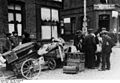
Refugees at Cambrai in September 1918

See also
 In Spanish: Cambrai para niños
