
Pas-de-Calais facts for kids
Quick facts for kids
Pas-de-Calais
Pas-Calés
|
|||
|---|---|---|---|

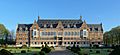
Prefecture building of the Pas-de-Calais department, in Arras
|
|||
|
|||

Location of Pas-de-Calais in France
|
|||
| Country | France | ||
| Region | Hauts-de-France | ||
| Prefecture | Arras | ||
| Subprefectures | Béthune, Boulogne-sur-Mer, Calais, Lens, Montreuil, Saint-Omer | ||
| Area | |||
| • Total | 6,671 km2 (2,576 sq mi) | ||
| Population
(2016)
|
|||
| • Total | 1,470,725 | ||
| • Rank | 8th | ||
| • Density | 220.465/km2 (571.00/sq mi) | ||
| Time zone | UTC+1 (CET) | ||
| • Summer (DST) | UTC+2 (CEST) | ||
| Department number | 62 | ||
| Arrondissements | 7 | ||
| Cantons | 39 | ||
| Communes | 890 | ||
| French Land Register data, which exclude estuaries, and lakes, ponds, and glaciers larger than 1 km2 | |||


Pas-de-Calais is a region in northern France. It is called a "department," which is like a state or province. Its name comes from the French name for the Strait of Dover, a narrow sea passage it borders.
Contents
History of Pas-de-Calais
Early Inhabitants and Languages
People have lived in the Pas-de-Calais area for a very long time, even before written history. Different groups settled here over the centuries. First came the Celtic people called the Belgae. Then, the Romans arrived. After them, Germanic tribes like the Franks and Alemanni moved in.
During the 300s and 400s, the Romans worked with Germanic tribes. They asked these tribes to help protect the area from Boulogne-sur-Mer to Cologne. This created a language border where people spoke either Germanic or Romance languages. This border lasted until the 700s.
Later, from the 400s to the 700s, Saxon people also settled here. They pushed the language border a bit further south and west. By the 800s, most people north of a line between Béthune and Berck spoke a type of Middle Dutch. People to the south spoke Picard, which is a Romance language.
You can still see this language history in the names of places and families today. From the 800s onwards, the Dutch language slowly moved north and east. By the end of the 1400s, Romance languages had completely taken over.
Forming the Department
Pas-de-Calais was one of the first 83 departments created in France. This happened during the French Revolution on March 4, 1790. It was formed from older areas like Calaisis (which used to belong to England), Boulonnais, Ponthieu, and Artois. Artois was once part of the Southern Netherlands.
World War History
Some of the most intense battles of World War I happened in this region. The Canadian National Vimy Memorial is a special place near Arras. It remembers the brave Canadian soldiers who fought in the Battle of Vimy Ridge. This battle was part of the larger Battle of Arras (1917). It is Canada's most important memorial in Europe for its fallen soldiers.
Pas-de-Calais was also important during World War II. It was part of a big plan called Operation Fortitude. The Allied forces wanted to trick the Germans into thinking the D-Day invasion would happen here. This made the Germans keep many soldiers in Pas-de-Calais, while the real invasion happened in Normandy.
Geography of Pas-de-Calais


Pas-de-Calais is located in the region called Hauts-de-France. It is surrounded by other French departments: Nord and Somme. It also borders the English Channel and the North Sea. It even shares a border with the English county of Kent in the middle of the Channel Tunnel.
Main Towns and Cities
The main towns along the coast are Calais, Boulogne-sur-Mer, and Étaples. In the area known as Artois, you will find towns like Lens, Liévin, Arras, and Saint-Omer.
Rivers of the Department
Here are the main rivers that flow through Pas-de-Calais:
- Authie
- Canche
- Ternoise
- Liane
- Sensée
- Scarpe
- Deûle
- Lys
- Aa
Economy of Pas-de-Calais
For a long time, the economy of Pas-de-Calais depended on coal mining. Coal was found near the town of Lens, Pas-de-Calais in 1849. However, after World War II, the economy started to change. It became more varied, with different types of industries and jobs.
Population of Pas-de-Calais
The people who live in this department are called Pas-de-Calaisiens.
Pas-de-Calais is one of the most crowded departments in France. However, it does not have any very large cities. Calais has about 80,000 people. Other important towns include Arras, Boulogne-sur-Mer, Lens, and Liévin.
Many people live in the mining area along the border with the Nord department. Here, many small towns form a large urban area with about 1.2 million people. The middle and southern parts of the department are more rural. Still, they have many villages and small towns, so they are quite populated.
Even though Pas-de-Calais saw very heavy fighting in World War I, its population quickly grew back after both world wars. However, many of the old mining towns have lost a lot of their population. Some have seen their numbers drop by half.
Images for kids
-
The Université d'Artois' campus in Lens sits in the ancient headquarters of Compagnie des mines.
-
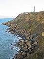
Cap Gris Nez
-
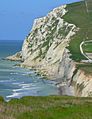
Cap Blanc Nez
-
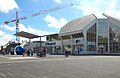
Nausicaä
-
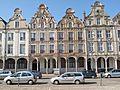
Grand-Place of Arras
-
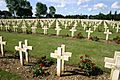
Notre Dame de Lorette
-
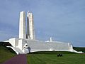
Canadian National Vimy Memorial, 11 kilometres from Arras
-
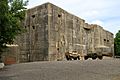
Blockhaus d'Éperlecques
-
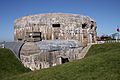
Todt Battery, Audinghen


.JPG)


_cropped.jpg)


See also
 In Spanish: Paso de Calais (departamento) para niños
