
Saint-Omer facts for kids
Quick facts for kids
Saint-Omer
|
||
|---|---|---|
|
Subprefecture and commune
|
||
|
The town hall
|
||
|
||

Saint-Omer
Location in France

Saint-Omer
Location in Hauts-de-France
|
||
| Country | France | |
| Region | Hauts-de-France | |
| Department | Pas-de-Calais | |
| Arrondissement | Saint-Omer | |
| Canton | Saint-Omer | |
| Intercommunality | Pays de Saint-Omer | |
| Area
1
|
16.4 km2 (6.3 sq mi) | |
| Time zone | UTC+01:00 (CET) | |
| • Summer (DST) | UTC+02:00 (CEST) | |
| INSEE/Postal code |
62765 /62500
|
|
| Elevation | 0–27 m (0–89 ft) (avg. 6 m or 20 ft) |
|
| 1 French Land Register data, which excludes lakes, ponds, glaciers > 1 km2 (0.386 sq mi or 247 acres) and river estuaries. | ||


Saint-Omer is a charming town located in France. It is known as a commune, which is like a local government area. It's also a sub-prefecture, meaning it's an important administrative center for the Pas-de-Calais department.
You can find Saint-Omer about 68 kilometers (42 miles) west-northwest of Lille. It's also on the railway line that goes to Calais. The town gets its name from Saint Audomar, a person who helped bring Christianity to this region a long time ago.
Geography and Waterways
Saint-Omer is located in a flat area. The town is connected to important waterways.
The Aa River and Canals
The river Aa starts its journey as a canalized (made into a canal) section right here in Saint-Omer. This river then flows all the way to the North Sea at Gravelines in northern France.
Near the town's old walls, the Aa River also connects with the Neufossé Canal. This canal is another important waterway that eventually joins up with the Lys River. These waterways were very important for trade and travel in the past.
Images for kids
-

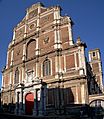
Cathedral
-
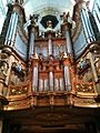
19th century Cavaillé-Coll organ in the cathedral
-

Main square and town hall
-
Former Saint-Omer College English chapel


See also
 In Spanish: Saint-Omer para niños
